
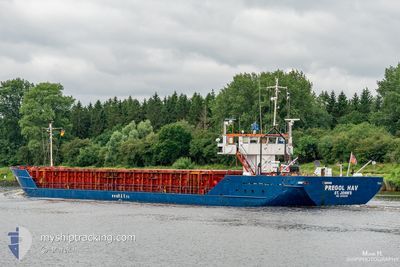
PREGOL HAV
General Cargo
Current Trip
| Time Travelled | 23 h, 27 mins |
|---|---|
| Remaining Time | 6 h, 27 mins |
| Distance Travelled | 188.99 nm |
| Remaining Distance | 60.43 nm |
| AVG Speed | 8 Knop |
| MAX Speed | 11.3 Knop |
| AVG Wind | 11.6 knots |
| MAX Wind | 15 knots |
| MIN Temp | 7.6°C / 45.68°F |
| MAX Temp | 14.7°C / 58.46°F |
| Djupgående | 4.3 m |
| Position mottagen | 13 m sen |
Current Position
| Longitud | --- |
|---|---|
| Latitude | --- |
| Status | Under way using engine |
| Fart | 8.5 Knop |
| Kurs | 318.2° |
| Område | North Sea |
| Station | T-AIS |
| Position mottagen | 13 m sen |
Info
Information
The current position of PREGOL HAV is in North Sea with coordinates 53.38678° / 0.52268° as reported on 2025-03-07 13:58 by AIS to our vessel tracker app. The vessel's current speed is 8.5 Knop and is heading at the port of GOOLE. The estimated time of arrival as calculated by MyShipTracking vessel tracking app is 2025-03-07 20:39 LT
The vessel PREGOL HAV (IMO: 8519239, MMSI: 305966000) is a General Cargo that was built in 1985 ( 40 År gammal ). It's sailing under the flag of [AG] Antigua Barbuda.
In this page you can find informations about the vessels current position, last detected port calls, and current voyage information. If the vessels is not in coverage by AIS you will find the latest position.
The current position of PREGOL HAV is detected by our AIS receivers and we are not responsible for the reliability of the data. The last position was recorded while the vessel was in Coverage by the Ais receivers of our vessel tracking app.
The current draught of PREGOL HAV as reported by AIS is 4.3 meters
Weather
| Temperature | 8.6°C / 47.48°F |
|---|---|
| Wind Speed | 11 knots |
| Direction | 165° SSE |
| Pressure | 1011.4 hPa |
| Humidity | 89.7 % |
| Cloud Coverage | 100 % |
Featured Company
Last Port Calls
| Port | Arrival | Departure | Time In Port |
|---|---|---|---|
| 2025-03-06 00:50 | 2025-03-06 14:45 | 13 h | |
| 2025-03-02 21:39 | 2025-03-04 19:50 | 1 d | |
| 2025-02-28 07:37 | 2025-03-01 10:43 | 1 d | |
| 2025-02-22 17:20 | 2025-02-25 21:27 | 3 d | |
| 2025-02-20 05:34 | 2025-02-21 16:34 | 1 d | |
| 2025-02-16 16:32 | 2025-02-19 13:35 | 2 d | |
| 2025-02-13 14:10 | 2025-02-13 14:18 | 7 m | |
| 2025-02-09 04:02 | 2025-02-11 13:11 | 2 d | |
| 2025-02-05 03:49 | 2025-02-05 15:01 | 11 h | |
| 2025-01-31 21:05 | 2025-02-03 20:27 | 2 d |
Last Trips
| Origin | Departure | Destination | Arrival | Distance | |
|---|---|---|---|---|---|
| 2025-03-04 19:50 | 2025-03-06 01:50 | 251.15 nm | |||
| 2025-03-01 11:43 | 2025-03-02 21:39 | 254.39 nm | |||
| 2025-02-25 21:27 | 2025-02-28 08:37 | 141.05 nm | |||
| 2025-02-21 17:34 | 2025-02-22 17:20 | 199.28 nm | |||
| 2025-02-19 14:35 | 2025-02-20 06:34 | 120.87 nm | |||
| 2025-02-13 14:18 | 2025-02-16 17:32 | 375.00 nm | |||
| 2025-02-11 13:11 | 2025-02-13 14:10 | 383.92 nm | |||
| 2025-02-05 16:01 | 2025-02-09 04:02 | 630.38 nm | |||
| 2025-02-03 20:27 | 2025-02-05 04:49 | 250.90 nm | |||
| 2025-01-31 17:12 | 2025-01-31 21:05 | 24.91 nm |
Events
| Tid | Event | Detaljer | Position / Dest | Information |
|---|---|---|---|---|
| 2025-03-07 13:49 | Status ändrad | Under way using engine Default |
53.36949 / .54800
GBGOO
|
Fart: 8.3 kn Kurs: 320° |
| 2025-03-07 13:17 | Status ändrad | Default Under way using engine |
53.31193 / .62814
GBGOO
|
Fart: 8.2 kn Kurs: 315.1° |
| 2025-03-07 13:06 | Status ändrad | Under way using engine Default |
53.29363 / .65438
GBGOO
|
Fart: 8.1 kn Kurs: 314° |
| 2025-03-07 13:02 | I täckningsområde |
53.29363 / .65438
North Sea
GBGOO
|
Fart: 8.2 kn Kurs: 315.1° |
|
| 2025-03-07 09:46 | Status ändrad | Default Under way using engine |
53.02229 / 1.17657
GBGOO
|
Fart: 8.3 kn Kurs: 297.9° |
| 2025-03-07 09:39 | UTANFÖR täckningsområde |
53.01470 / 1.19973
North Sea
GBGOO
|
Fart: 8.3 kn Kurs: 297.9° |
|
| 2025-03-07 07:25 | Status ändrad | Under way using engine Default |
52.81729 / 1.66994
GBGOO
|
Fart: 10.4 kn Kurs: 306° |
| 2025-03-07 06:53 | Status ändrad | Default Under way using engine |
52.74517 / 1.75895
GBGOO
|
Fart: 11 kn Kurs: 328.5° |
| 2025-03-06 18:41 | Byter havsområde | United Kingdom part of the North Sea French part of the North Sea |
51.09391 / 1.69454
North Sea
GBGOO
|
Fart: 8.1 kn Kurs: 312.7° |
| 2025-03-06 16:37 | Status ändrad | Under way using engine Default |
51.04992 / 2.04450
GBGOO
|
Fart: 5.9 kn Kurs: 261° |