

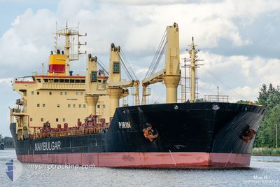
PIRIN
Bulk Carrier

Current Trip
| Time Travelled | 5 days |
|---|---|
| Remaining Time | --- |
| Distance Travelled | 1370.00 nm |
| Remaining Distance | --- |
| AVG Speed | 10.7 Knop |
| MAX Speed | 11.9 Knop |
| AVG Wind | 12.3 knots |
| MAX Wind | 24 knots |
| MIN Temp | 11.9°C / 53.42°F |
| MAX Temp | 18.2°C / 64.76°F |
| Djupgående | 8.9 m |
| Position mottagen | 1 d sen |
Current Position
| Longitud | --- |
|---|---|
| Latitude | --- |
| Status | Under way using engine |
| Fart | 10.5 Knop |
| Kurs | 281.8° |
| Område | Mediterranean Sea - Eastern Basin |
| Station | T-AIS |
| Position mottagen | 1 d sen |
Information
The current position of PIRIN is in Mediterranean Sea - Eastern Basin with coordinates 36.87187° / 13.76774° as reported on 2025-03-25 20:04 by AIS to our vessel tracker app. The vessel's current speed is 10.5 Knop and is heading at the port of AMSTERDAM. The estimated time of arrival as calculated by MyShipTracking vessel tracking app is 2025-04-04 11:00 LT
The vessel PIRIN (IMO: 9381861, MMSI: 256562000) is a Bulk Carrier that was built in 2007 ( 18 År gammal ). It's sailing under the flag of [MT] Malta.
In this page you can find informations about the vessels current position, last detected port calls, and current voyage information. If the vessels is not in coverage by AIS you will find the latest position.
The current position of PIRIN is detected by our AIS receivers and we are not responsible for the reliability of the data. The last position was recorded while the vessel was in Coverage by the Ais receivers of our vessel tracking app.
The current draught of PIRIN as reported by AIS is 8.9 meters
Weather
| Temperature | 15.1°C / 59.18°F |
|---|---|
| Wind Speed | 19 knots |
| Direction | 320° NW |
| Pressure | 1015.2 hPa |
| Humidity | 68.1 % |
| Cloud Coverage | 8 % |


Featured Company
Most Visited Ports (Last year)
| Port | Arrivals | |
|---|---|---|
| 5 | ||
| 3 | ||
| 2 | ||
| 2 | ||
| 2 | ||
| 2 |
Events
| Tid | Event | Detaljer | Position / Dest | Information |
|---|---|---|---|---|
| 2025-03-25 20:12 | Status ändrad | Default Under way using engine |
36.87701 / 13.73752
NL AMS
|
Fart: 10.5 kn Kurs: 281.8° |
| 2025-03-25 20:04 | UTANFÖR täckningsområde |
36.87187 / 13.76774
Mediterranean Sea - Eastern Basin
NL AMS
|
Fart: 10.5 kn Kurs: 281.8° |
|
| 2025-03-25 19:56 | Status ändrad | Under way using engine Default |
36.86757 / 13.79343
NL AMS
|
Fart: 10.6 kn Kurs: 282° |
| 2025-03-25 19:42 | Status ändrad | Default Under way using engine |
36.85867 / 13.84606
NL AMS
|
Fart: 10.9 kn Kurs: 282.7° |
| 2025-03-25 17:09 | Status ändrad | Under way using engine Default |
36.71073 / 14.40819
NL AMS
|
Fart: 10.8 kn Kurs: 286° |
| 2025-03-25 16:54 | Status ändrad | Default Under way using engine |
36.69640 / 14.46186
NL AMS
|
Fart: 10.7 kn Kurs: 287.6° |
| 2025-03-25 16:52 | Status ändrad | Under way using engine Default |
36.69429 / 14.47027
NL AMS
|
Fart: 10.8 kn Kurs: 286° |
| 2025-03-25 16:35 | Status ändrad | Default Under way using engine |
36.67941 / 14.53126
NL AMS
|
Fart: 10.8 kn Kurs: 286.4° |
| 2025-03-25 16:33 | Status ändrad | Under way using engine Default |
36.67777 / 14.53777
NL AMS
|
Fart: 10.8 kn Kurs: 284° |
| 2025-03-25 16:01 | Status ändrad | Default Under way using engine |
36.65277 / 14.65334
NL AMS
|
Fart: 11.2 kn Kurs: 285.1° |