
PIANO LAND
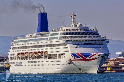
Passengers Ship
Current Trip
| Time Travelled | 5 days |
|---|---|
| Remaining Time | --- |
| Distance Travelled | 935.24 nm |
| Remaining Distance | 454.95 nm |
| AVG Speed | 13 Knop |
| MAX Speed | 18.1 Knop |
| AVG Wind | 11.4 knots |
| MAX Wind | 20.2 knots |
| MIN Temp | 0.9°C / 33.62°F |
| MAX Temp | 17.6°C / 63.68°F |
| Djupgående | 8.3 m |
| Position mottagen | 9 d sen |
Current Position
| Longitud | --- |
|---|---|
| Latitude | --- |
| Status | Under way using engine |
| Fart | 11.2 Knop |
| Kurs | 295° |
| Område | Japan Sea |
| Station | T-AIS |
| Position mottagen | 9 d sen |
Info
Information
The current position of PIANO LAND is in Japan Sea with coordinates 33.63654° / 130.34016° as reported on 2025-02-09 13:12 by AIS to our vessel tracker app. The vessel's current speed is 11.2 Knop and is heading at the port of SHANGHAI. The estimated time of arrival as calculated by MyShipTracking vessel tracking app is 2025-02-11 01:00 LT
The vessel PIANO LAND (IMO: 9050137, MMSI: 310529000) is a Passengers Ship that was built in 1995 ( 30 År gammal ). It's sailing under the flag of [BM] Bermuda.
In this page you can find informations about the vessels current position, last detected port calls, and current voyage information. If the vessels is not in coverage by AIS you will find the latest position.
The current position of PIANO LAND is detected by our AIS receivers and we are not responsible for the reliability of the data. The last position was recorded while the vessel was in Coverage by the Ais receivers of our vessel tracking app.
The current draught of PIANO LAND as reported by AIS is 8.3 meters
Weather
| Temperature | 13.5°C / 56.3°F |
|---|---|
| Wind Speed | 12 knots |
| Direction | 20° NNE |
| Pressure | 1025.2 hPa |
| Humidity | 59.3 % |
| Cloud Coverage | 17 % |
Featured Company
Last Port Calls
| Port | Arrival | Departure | Time In Port |
|---|---|---|---|
| 2025-02-13 10:37 | 2025-02-13 22:09 | 11 h | |
| 2025-02-09 09:37 | 2025-02-09 22:17 | 12 h | |
| 2025-02-05 10:45 | 2025-02-05 22:17 | 11 h | |
| 2025-02-01 07:59 | 2025-02-01 19:40 | 11 h | |
| 2025-01-30 12:33 | 2025-01-30 21:14 | 8 h | |
| 2025-01-27 08:46 | 2025-01-27 22:27 | 13 h | |
| 2025-01-26 12:50 | 2025-01-26 21:13 | 8 h | |
| 2025-01-23 12:27 | 2025-01-23 21:13 | 8 h | |
| 2025-01-20 09:55 | 2025-01-20 22:15 | 12 h | |
| 2025-01-19 11:05 | 2025-01-19 21:04 | 9 h |
Last Trips
| Origin | Departure | Destination | Arrival | Distance | |
|---|---|---|---|---|---|
| 2025-02-09 22:17 | 2025-02-13 10:37 | 1005.75 nm | |||
| 2025-02-05 22:17 | 2025-02-09 09:37 | 948.73 nm | |||
| 2025-02-01 19:40 | 2025-02-05 10:45 | 998.75 nm | |||
| 2025-01-30 21:14 | 2025-02-01 07:59 | 291.40 nm | |||
| 2025-01-27 22:27 | 2025-01-30 12:33 | 810.42 nm | |||
| 2025-01-26 21:13 | 2025-01-27 08:46 | 188.30 nm | |||
| 2025-01-23 21:13 | 2025-01-26 12:50 | 637.69 nm | |||
| 2025-01-20 22:15 | 2025-01-23 12:27 | 812.83 nm | |||
| 2025-01-19 21:04 | 2025-01-20 09:55 | 194.21 nm | |||
| 2025-01-10 19:37 | 2025-01-19 11:05 | 2415.32 nm |
Events
| Tid | Event | Detaljer | Position / Dest | Information |
|---|---|---|---|---|
| 2025-02-17 00:45 | STOPPAR förflyttning |
26.22505 / 127.67335
CN>SHA
|
Fart: 0.2 kn Kurs: 221° |
|
| 2025-02-15 06:53 | STARTAR förflyttning | 5.74 nm, North West of SHANGHAI |
31.41435 / 121.50880
CN>SHA
|
Fart: 3.9 kn Kurs: 117° |
| 2025-02-14 22:41 | STOPPAR förflyttning | 5.83 nm, North West of SHANGHAI |
31.41203 / 121.50522
CN>SHA
|
Fart: 0.1 kn Kurs: 300° |
| 2025-02-13 13:09 | AVGÅTT HAMN |
|
33.13062 / 129.71513
CN>SHA
|
Fart: 10.9 kn Kurs: 179° |
| 2025-02-13 12:53 | STARTAR förflyttning |
33.15621 / 129.71878
[JP] SASEBO
|
Fart: 3.5 kn Kurs: 58° |
|
| 2025-02-13 02:09 | STOPPAR förflyttning |
33.16033 / 129.72530
[JP] SASEBO
|
Fart: 0.2 kn Kurs: 44° |
|
| 2025-02-13 01:37 | ANLÄNDER HAMN |
|
33.14423 / 129.71158
[JP] SASEBO
|
Fart: 7.9 kn Kurs: 346° |
| 2025-02-11 08:13 | STARTAR förflyttning | 5.26 nm, North West of SHANGHAI |
31.41104 / 121.51742
CN>SHA
|
Fart: 8.4 kn Kurs: 114° |
| 2025-02-10 22:21 | STOPPAR förflyttning | 5.79 nm, North West of SHANGHAI |
31.41215 / 121.50601
CN>SHA
|
Fart: 0.3 kn Kurs: 301° |
| 2025-02-09 13:12 | UTANFÖR täckningsområde |
33.63654 / 130.34016
Japan Sea
CN>SHA
|
Fart: 11.2 kn Kurs: 296° |