
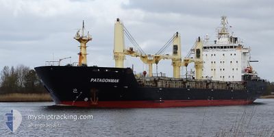
PATAGONMAN
Bulk Carrier
Current Trip
| Time Travelled | 10 days |
|---|---|
| Remaining Time | --- |
| Distance Travelled | 2760.98 nm |
| Remaining Distance | --- |
| AVG Speed | 12 Knop |
| MAX Speed | 19.4 Knop |
| AVG Wind | 11 knots |
| MAX Wind | 29.8 knots |
| MIN Temp | 1.1°C / 33.98°F |
| MAX Temp | 17.4°C / 63.32°F |
| Djupgående | 8.1 m |
| Position mottagen | 46 m sen |
Current Position
| Longitud | -15.21062° |
|---|---|
| Latitude | 37.81353° |
| Status | Under way using engine |
| Fart | 11.3 Knop |
| Kurs | 109° |
| Område | North Atlantic Ocean |
| Station | T-AIS |
| Position mottagen | 46 m sen |
Info
Information
The current position of PATAGONMAN is in North Atlantic Ocean with coordinates 37.81353° / -15.21062° as reported on 2024-05-07 16:07 by AIS to our vessel tracker app. The vessel's current speed is 11.3 Knop and is heading at the port of SAVONA. The estimated time of arrival as calculated by MyShipTracking vessel tracking app is 2024-05-13 08:00 LT
The vessel PATAGONMAN (IMO: 9521851, MMSI: 563150200) is a Bulk Carrier that was built in 2012 ( 12 År gammal ). It's sailing under the flag of [SG] Singapore.
In this page you can find informations about the vessels current position, last detected port calls, and current voyage information. If the vessels is not in coverage by AIS you will find the latest position.
The current position of PATAGONMAN is detected by our AIS receivers and we are not responsible for the reliability of the data. The last position was recorded while the vessel was in Coverage by the Ais receivers of our vessel tracking app.
The current draught of PATAGONMAN as reported by AIS is 8.1 meters
Weather
| Temperature | 16.1°C / 60.98°F |
|---|---|
| Wind Speed | 11 knots |
| Direction | 88° E |
| Pressure | 1021.1 hPa |
| Humidity | 74.3 % |
| Cloud Coverage | 100 % |
Featured Company
Last Port Calls
| Port | Arrival | Departure | Time In Port |
|---|---|---|---|
| 2024-04-27 07:17 | 2024-04-27 15:42 | 8 h | |
| 2024-04-25 23:22 | 2024-04-26 00:03 | 40 m | |
| 2024-04-23 17:39 | 2024-04-23 18:26 | 47 m | |
| 2024-04-21 00:04 | 2024-04-22 22:14 | 1 d | |
| 2024-04-18 18:37 | 2024-04-18 19:16 | 38 m | |
| 2024-04-09 14:11 | 2024-04-15 23:15 | 6 d | |
| 2024-04-06 15:26 | 2024-04-06 16:01 | 34 m | |
| 2024-04-05 05:08 | 2024-04-05 07:31 | 2 h | |
| 2024-03-14 05:16 | 2024-03-19 19:09 | 5 d | |
| 2024-03-07 19:57 | 2024-03-10 22:12 | 3 d |
Most Visited Ports (Last year)
| Port | Arrivals | |
|---|---|---|
| 8 | ||
| 8 | ||
| 8 | ||
| 4 | ||
| 4 | ||
| 4 |
Last Trips
| Origin | Departure | Destination | Arrival | Distance | |
|---|---|---|---|---|---|
| 2024-04-25 20:03 | 2024-04-27 03:17 | 296.38 nm | |||
| 2024-04-23 14:26 | 2024-04-25 19:22 | 528.37 nm | |||
| 2024-04-22 18:14 | 2024-04-23 13:39 | 236.29 nm | |||
| 2024-04-18 15:16 | 2024-04-20 20:04 | 231.19 nm | |||
| 2024-04-15 18:15 | 2024-04-18 14:37 | 369.65 nm | |||
| 2024-04-06 12:01 | 2024-04-09 09:11 | 809.41 nm | |||
| 2024-04-05 03:31 | 2024-04-06 11:26 | 297.02 nm | |||
| 2024-03-19 20:09 | 2024-04-05 01:08 | 3961.83 nm | |||
| 2024-03-10 22:12 | 2024-03-14 06:16 | 856.44 nm | |||
| 2024-02-18 07:44 | 2024-03-07 19:57 | 4811.50 nm |
Events
| Tid | Event | Detaljer | Position / Dest | Information |
|---|---|---|---|---|
| 2024-05-07 16:31 | Status ändrad | Default Under way using engine |
37.78485 / -15.11899
ITSVN
|
Fart: 11.3 kn Kurs: 109° |
| 2024-05-07 16:05 | Status ändrad | Under way using engine Default |
37.81536 / -15.21667
ITSVN
|
Fart: 11.3 kn Kurs: 113° |
| 2024-05-07 16:01 | Status ändrad | Default Under way using engine |
37.82016 / -15.23259
ITSVN
|
Fart: 11.2 kn Kurs: 111° |
| 2024-05-07 15:54 | Status ändrad | Under way using engine Default |
37.82778 / -15.25743
ITSVN
|
Fart: 11.2 kn Kurs: 108° |
| 2024-05-07 15:30 | Status ändrad | Default Under way using engine |
37.85406 / -15.34367
ITSVN
|
Fart: 11.2 kn Kurs: 110° |
| 2024-05-07 15:21 | Status ändrad | Under way using engine Default |
37.86439 / -15.37812
ITSVN
|
Fart: 11.3 kn Kurs: 109° |
| 2024-05-07 15:04 | Status ändrad | Default Under way using engine |
37.88223 / -15.44068
ITSVN
|
Fart: 11.5 kn Kurs: 109° |
| 2024-05-07 15:00 | Status ändrad | Under way using engine Default |
37.88694 / -15.45758
ITSVN
|
Fart: 11.5 kn Kurs: 111° |
| 2024-05-07 14:44 | Status ändrad | Default Under way using engine |
37.90358 / -15.51799
ITSVN
|
Fart: 11.2 kn Kurs: 110° |
| 2024-05-07 14:29 | Upptäckt i hav | High seas of the North Atlantic Ocean |
37.91985 / -15.57519
North Atlantic Ocean
ITSVN
|
Fart: 11.2 kn Kurs: 110° |