
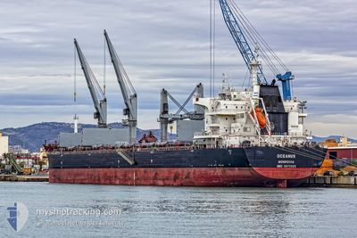
OCEANUS
Cargo
Current Trip
CNYJI
| Time Travelled | 7 days |
|---|---|
| Remaining Time | --- |
| Distance Travelled | 1664.99 nm |
| Remaining Distance | --- |
| AVG Speed | 12.1 Knop |
| MAX Speed | 14.3 Knop |
| AVG Wind | 7.5 knots |
| MAX Wind | 17.3 knots |
| MIN Temp | 26°C / 78.8°F |
| MAX Temp | 30.1°C / 86.18°F |
| Djupgående | 12.5 m |
| Position mottagen | 15 d sen |
Current Position
| Longitud | 104.27857° |
|---|---|
| Latitude | 1.28158° |
| Status | Under way using engine |
| Fart | 10.7 Knop |
| Kurs | 82.7° |
| Område | Singapore Strait |
| Station | T-AIS |
| Position mottagen | 15 d sen |
Info
Information
The current position of OCEANUS is in Singapore Strait with coordinates 1.28158° / 104.27857° as reported on 2024-04-27 16:42 by AIS to our vessel tracker app. The vessel's current speed is 10.7 Knop
The vessel OCEANUS (IMO: 9670925, MMSI: 636016601) is a Cargo It's sailing under the flag of [LR] Liberia.
In this page you can find informations about the vessels current position, last detected port calls, and current voyage information. If the vessels is not in coverage by AIS you will find the latest position.
The current position of OCEANUS is detected by our AIS receivers and we are not responsible for the reliability of the data. The last position was recorded while the vessel was in Coverage by the Ais receivers of our vessel tracking app.
The current draught of OCEANUS as reported by AIS is 12.5 meters
Weather
| Temperature | 28°C / 82.4°F |
|---|---|
| Wind Speed | 8 knots |
| Direction | 188° S |
| Pressure | 1007.8 hPa |
| Humidity | 82.1 % |
| Cloud Coverage | 27 % |
Featured Company
Last Port Calls
| Port | Arrival | Departure | Time In Port |
|---|---|---|---|
| 2024-05-05 01:57 | 2024-05-06 11:44 | 1 d | |
| 2024-03-12 16:03 |
Most Visited Ports (Last year)
| Port | Arrivals | |
|---|---|---|
| 2 | ||
| 2 | ||
| 2 | ||
| 1 | ||
| 1 | ||
| 1 |
Last Trips
| Origin | Departure | Destination | Arrival | Distance | |
|---|---|---|---|---|---|
| 2024-02-25 16:43 | 2024-03-12 16:03 | 690.63 nm |
Events
| Tid | Event | Detaljer | Position / Dest | Information |
|---|---|---|---|---|
| 2024-05-12 06:50 | STOPPAR förflyttning | 12.09 nm, East of BALIKPAPAN |
-1.34032 / 116.99432
CNYJI
|
Fart: 0.2 kn Kurs: 234° |
| 2024-05-12 05:44 | STARTAR förflyttning | 12.11 nm, South East of BALIKPAPAN |
-1.35478 / 116.98909
CNYJI
|
Fart: 3.4 kn Kurs: 47° |
| 2024-05-12 03:44 | STOPPAR förflyttning | 12.33 nm, South East of BALIKPAPAN |
-1.35949 / 116.99088
CNYJI
|
Fart: 0.2 kn Kurs: 306° |
| 2024-05-06 11:44 | STARTAR förflyttning | 0.45 nm, South of YANGJIANG |
21.69036 / 111.81790
CNYJI
|
Fart: 3.3 kn Kurs: 179° |
| 2024-05-06 11:44 | AVGÅTT HAMN |
|
21.69036 / 111.81790
CNYJI
|
Fart: 1.9 kn Kurs: 191° |
| 2024-05-05 02:05 | STOPPAR förflyttning |
21.69200 / 111.82057
[CN] YANGJIANG
|
Fart: 0.3 kn Kurs: 337° |
|
| 2024-05-05 01:57 | ANLÄNDER HAMN |
|
21.69078 / 111.81983
[CN] YANGJIANG
|
Fart: 1.1 kn Kurs: 355° |
| 2024-05-04 23:27 | STARTAR förflyttning | 16.67 nm, South of YANGJIANG |
21.41907 / 111.81706
CNYJI
|
Fart: 3.4 kn Kurs: 41° |