
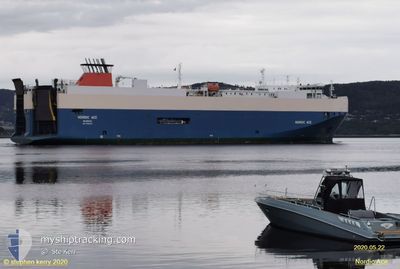
NORDIC RAY
Vehicles Carrier
Current Trip
| Time Travelled | 10 h, 45 mins |
|---|---|
| Remaining Time | 1 day |
| Distance Travelled | 169.51 nm |
| Remaining Distance | 479.30 nm |
| AVG Speed | 16 Knop |
| MAX Speed | 19.4 Knop |
| AVG Wind | 9.3 knots |
| MAX Wind | 13.6 knots |
| MIN Temp | 7.8°C / 46.04°F |
| MAX Temp | 11.7°C / 53.06°F |
| Djupgående | 7.2 m |
| Position mottagen | Nu |
Current Position
| Longitud | 10.29068° |
|---|---|
| Latitude | 57.81955° |
| Status | Under way using engine |
| Fart | 15.3 Knop |
| Kurs | 247.6° |
| Område | Skaggerak |
| Station | T-AIS |
| Position mottagen | Nu |
Info
Information
The current position of NORDIC RAY is in Skaggerak with coordinates 57.81955° / 10.29068° as reported on 2024-04-27 23:55 by AIS to our vessel tracker app. The vessel's current speed is 15.3 Knop and is heading at the port of ZEEBRUGGE. The estimated time of arrival as calculated by MyShipTracking vessel tracking app is 2024-04-29 07:30 LT
The vessel NORDIC RAY (IMO: 9386225, MMSI: 309586000) is a Vehicles Carrier that was built in 2007 ( 17 År gammal ). It's sailing under the flag of [BS] Bahamas.
In this page you can find informations about the vessels current position, last detected port calls, and current voyage information. If the vessels is not in coverage by AIS you will find the latest position.
The current position of NORDIC RAY is detected by our AIS receivers and we are not responsible for the reliability of the data. The last position was recorded while the vessel was in Coverage by the Ais receivers of our vessel tracking app.
The current draught of NORDIC RAY as reported by AIS is 7.2 meters
Weather
| Temperature | 7.6°C / 45.68°F |
|---|---|
| Wind Speed | 14 knots |
| Direction | 78° ENE |
| Pressure | 1014.1 hPa |
| Humidity | 85.2 % |
| Cloud Coverage | 100 % |
Featured Company
Last Port Calls
| Port | Arrival | Departure | Time In Port |
|---|---|---|---|
| 2024-04-27 07:09 | 2024-04-27 13:11 | 6 h | |
| 2024-04-26 03:59 | 2024-04-26 13:13 | 9 h | |
| 2024-04-23 14:19 | 2024-04-24 15:59 | 1 d | |
| 2024-04-21 03:24 | 2024-04-21 14:21 | 10 h | |
| 2024-04-20 08:08 | 2024-04-20 13:59 | 5 h | |
| 2024-04-19 06:58 | 2024-04-19 14:18 | 7 h | |
| 2024-04-16 11:21 | 2024-04-17 20:40 | 1 d | |
| 2024-04-14 01:45 | 2024-04-14 13:34 | 11 h | |
| 2024-04-13 09:37 | 2024-04-13 14:22 | 4 h | |
| 2024-04-11 22:46 | 2024-04-12 14:01 | 15 h |
Last Trips
| Origin | Departure | Destination | Arrival | Distance | |
|---|---|---|---|---|---|
| 2024-04-26 15:13 | 2024-04-27 09:09 | 266.60 nm | |||
| 2024-04-24 17:59 | 2024-04-26 05:59 | 602.54 nm | |||
| 2024-04-21 16:21 | 2024-04-23 16:19 | 569.74 nm | |||
| 2024-04-20 15:59 | 2024-04-21 05:24 | 136.59 nm | |||
| 2024-04-19 16:18 | 2024-04-20 10:08 | 267.50 nm | |||
| 2024-04-17 22:40 | 2024-04-19 08:58 | 606.88 nm | |||
| 2024-04-14 15:34 | 2024-04-16 13:21 | 574.20 nm | |||
| 2024-04-13 16:22 | 2024-04-14 03:45 | 148.37 nm | |||
| 2024-04-12 16:01 | 2024-04-13 11:37 | 328.27 nm | |||
| 2024-04-11 16:16 | 2024-04-12 00:46 | 143.41 nm |
Events
| Tid | Event | Detaljer | Position / Dest | Information |
|---|---|---|---|---|
| 2024-04-27 22:32 | Byter havsområde | Danish part of the Skaggerak Danish part of the Kattegat |
57.80932 / 10.92688
Skaggerak
BE ZEE
|
Fart: 15.6 kn Kurs: 317.4° |
| 2024-04-27 21:38 | Byter havsområde | Danish part of the Kattegat Swedish part of the Kattegat |
57.63975 / 11.21566
Kattegat
BE ZEE
|
Fart: 15.7 kn Kurs: 318.1° |
| 2024-04-27 15:20 | Byter havsområde | Swedish part of the Kattegat Danish part of the Kattegat |
56.13375 / 12.51604
Kattegat
BE ZEE
|
Fart: 16.8 kn Kurs: 316° |
| 2024-04-27 15:11 | Byter havsområde | Danish part of the Kattegat Swedish part of the Kattegat |
56.10312 / 12.56916
Kattegat
BE ZEE
|
Fart: 17.3 kn Kurs: 315.3° |
| 2024-04-27 13:11 | AVGÅTT HAMN |
|
55.62747 / 12.97971
BE ZEE
|
Fart: 6 kn Kurs: 322° |
| 2024-04-27 13:00 | STARTAR förflyttning |
55.61716 / 13.00191
[SE] MALMO
|
Fart: 3.5 kn Kurs: 278° |
|
| 2024-04-27 12:56 | ETA ändrat | 2024/04/29 12:00 2024/04/29 08:00 |
55.61732 / 13.00413
[SE] MALMO
|
Fart: 0.4 kn Kurs: 287° |
| 2024-04-27 12:55 | Status ändrad | Under way using engine Moored |
55.61745 / 13.00430
[SE] MALMO
|
Fart: Kurs: 288° |
| 2024-04-27 11:45 | Djupgående ändrat | 7.2 7.3 |
55.61753 / 13.00441
[SE] MALMO
|
Fart: Kurs: 288° |
| 2024-04-27 11:39 | Destination ändrad | BE ZEE SE MMA |
55.61752 / 13.00439
[SE] MALMO
|
Fart: Kurs: 288° |