

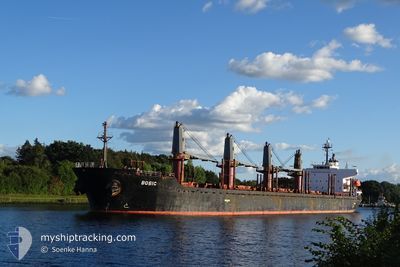
MV BOBIC
Bulk Carrier

Current Trip
| Time Travelled | 14 days |
|---|---|
| Remaining Time | --- |
| Distance Travelled | 3721.90 nm |
| Remaining Distance | --- |
| AVG Speed | 11.7 Knop |
| MAX Speed | 13.7 Knop |
| AVG Wind | 9.3 knots |
| MAX Wind | 21.8 knots |
| MIN Temp | 22.8°C / 73.04°F |
| MAX Temp | 29.5°C / 85.1°F |
| Djupgående | 9.7 m |
| Position mottagen | 2 d sen |
Current Position
| Longitud | --- |
|---|---|
| Latitude | --- |
| Status | Under way using engine |
| Fart | 10.3 Knop |
| Kurs | 273° |
| Område | Indian Ocean |
| Station | T-AIS |
| Position mottagen | 2 d sen |
Information
The current position of MV BOBIC is in Indian Ocean with coordinates -20.14667° / 57.41065° as reported on 2025-03-25 09:58 by AIS to our vessel tracker app. The vessel's current speed is 10.3 Knop and is heading at the port of GEBZE. The estimated time of arrival as calculated by MyShipTracking vessel tracking app is 2025-04-26 23:00 LT
The vessel MV BOBIC (IMO: 9317781, MMSI: 538006462) is a Bulk Carrier that was built in 2006 ( 19 År gammal ). It's sailing under the flag of [MH] Marshall Is.
In this page you can find informations about the vessels current position, last detected port calls, and current voyage information. If the vessels is not in coverage by AIS you will find the latest position.
The current position of MV BOBIC is detected by our AIS receivers and we are not responsible for the reliability of the data. The last position was recorded while the vessel was in Coverage by the Ais receivers of our vessel tracking app.
The current draught of MV BOBIC as reported by AIS is 9.7 meters
Weather
| Temperature | 26.5°C / 79.7°F |
|---|---|
| Wind Speed | 15 knots |
| Direction | 69° ENE |
| Pressure | 1015.1 hPa |
| Humidity | 77.4 % |
| Cloud Coverage | 53 % |


Featured Company
Events
| Tid | Event | Detaljer | Position / Dest | Information |
|---|---|---|---|---|
| 2025-03-25 10:05 | Status ändrad | Default Under way using engine |
-20.14635 / 57.38804
TR GEB
|
Fart: 10.3 kn Kurs: 273° |
| 2025-03-25 09:58 | Status ändrad | Under way using engine Default |
-20.14667 / 57.41065
TR GEB
|
Fart: 10.1 kn Kurs: 272° |
| 2025-03-25 09:58 | UTANFÖR täckningsområde |
-20.14667 / 57.41065
Indian Ocean
|
Fart: 10.3 kn Kurs: 273° |
|
| 2025-03-25 09:53 | Status ändrad | Default Under way using engine |
-20.14450 / 57.42505
TR GEB
|
Fart: 6.3 kn Kurs: 268° |
| 2025-03-25 09:46 | Byter havsområde | Mauritian part of the Indian Ocean Malaysian part of the Malacca Strait |
-20.13992 / 57.44165
Indian Ocean
|
Fart: 6.3 kn Kurs: 268° |
| 2025-03-25 09:38 | STARTAR förflyttning | 1.83 nm, West of PORT LOUIS |
-20.14642 / 57.45052
TR GEB
|
Fart: 3.1 kn Kurs: 313° |
| 2025-03-25 09:31 | Status ändrad | Under way using engine At anchor |
-20.14795 / 57.45367
TR GEB
|
Fart: 1 kn Kurs: 256° |
| 2025-03-25 09:26 | Destination ändrad | TR GEB G |
-20.14732 / 57.45562
TR GEB
|
Fart: 1.1 kn Kurs: 253° |
| 2025-03-25 09:26 | ETA ändrat | 2025/04/26 20:00 2025/03/24 12:00 |
-20.14732 / 57.45562
TR GEB
|
Fart: 1.1 kn Kurs: 253° |
| 2025-03-25 09:24 | Destination ändrad | G MU PLU |
-20.14717 / 57.45652
G
|
Fart: 0.4 kn Kurs: 260° |