

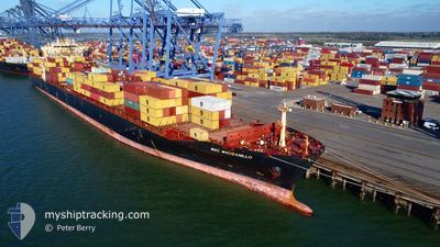
MSC MANZANILLO
Container Ship

Current Trip
| Time Travelled | 18 h, 29 mins |
|---|---|
| Remaining Time | 16 h, 28 mins |
| Distance Travelled | 290.41 nm |
| Remaining Distance | 245.33 nm |
| AVG Speed | 15.4 Knop |
| MAX Speed | 20 Knop |
| AVG Wind | 14.2 knots |
| MAX Wind | 20 knots |
| MIN Temp | 8.6°C / 47.48°F |
| MAX Temp | 11.4°C / 52.52°F |
| Djupgående | 11.6 m |
| Position mottagen | Nu |
Current Position
| Longitud | --- |
|---|---|
| Latitude | --- |
| Status | Under way using engine |
| Fart | 14.6 Knop |
| Kurs | 0.4° |
| Område | Celtic Sea |
| Station | T-AIS |
| Position mottagen | Nu |
Information
The current position of MSC MANZANILLO is in Celtic Sea with coordinates 50.64131° / -5.87954° as reported on 2025-03-28 08:21 by AIS to our vessel tracker app. The vessel's current speed is 14.6 Knop and is heading at the port of LIVERPOOL. The estimated time of arrival as calculated by MyShipTracking vessel tracking app is 2025-03-29 00:50 LT
The vessel MSC MANZANILLO (IMO: 9289960, MMSI: 255792000) is a Container Ship that was built in 2005 ( 20 År gammal ). It's sailing under the flag of [PT] Portugal.
In this page you can find informations about the vessels current position, last detected port calls, and current voyage information. If the vessels is not in coverage by AIS you will find the latest position.
The current position of MSC MANZANILLO is detected by our AIS receivers and we are not responsible for the reliability of the data. The last position was recorded while the vessel was in Coverage by the Ais receivers of our vessel tracking app.
The current draught of MSC MANZANILLO as reported by AIS is 11.6 meters
Weather
| Temperature | 9.2°C / 48.56°F |
|---|---|
| Wind Speed | 20 knots |
| Direction | 310° NW |
| Pressure | 1015.8 hPa |
| Humidity | 81.6 % |
| Cloud Coverage | --- |


Featured Company
Last Port Calls
| Port | Arrival | Departure | Time In Port |
|---|---|---|---|
| 2025-03-25 12:45 | 2025-03-27 14:53 | 2 d | |
| 2025-03-23 05:10 | 2025-03-24 02:09 | 20 h | |
| 2025-03-19 20:27 | 2025-03-21 08:14 | 1 d | |
| 2025-03-04 07:35 | 2025-03-10 07:03 | 5 d | |
| 2025-02-18 14:57 | 2025-02-19 14:17 | 23 h | |
| 2025-02-16 05:19 | 2025-02-17 05:17 | 23 h | |
| 2025-02-13 21:50 | 2025-02-14 14:28 | 16 h | |
| 2025-02-10 12:44 | 2025-02-11 19:24 | 1 d | |
| 2025-01-26 14:23 | 2025-01-29 11:14 | 2 d | |
| 2025-01-12 22:20 | 2025-01-13 22:34 | 1 d |
Last Trips
| Origin | Departure | Destination | Arrival | Distance | |
|---|---|---|---|---|---|
| 2025-03-24 02:09 | 2025-03-25 12:45 | 518.94 nm | |||
| 2025-03-21 08:14 | 2025-03-23 05:10 | 373.09 nm | |||
| 2025-03-10 07:03 | 2025-03-19 20:27 | 3303.75 nm | |||
| 2025-02-19 14:17 | 2025-03-04 07:35 | 4487.47 nm | |||
| 2025-02-17 05:17 | 2025-02-18 14:57 | 533.45 nm | |||
| 2025-02-14 14:28 | 2025-02-16 05:19 | 525.39 nm | |||
| 2025-02-11 19:24 | 2025-02-13 21:50 | 408.17 nm | |||
| 2025-01-29 11:14 | 2025-02-10 12:44 | 4479.44 nm | |||
| 2025-01-13 22:34 | 2025-01-26 14:23 | 4871.90 nm | |||
| 2025-01-11 01:03 | 2025-01-12 22:20 | 532.32 nm |
Events
| Tid | Event | Detaljer | Position / Dest | Information |
|---|---|---|---|---|
| 2025-03-28 05:12 | Status ändrad | Under way using engine Default |
49.88915 / -5.88277
GBLIV
|
Fart: 15.2 kn Kurs: 327° |
| 2025-03-28 04:44 | Status ändrad | Default Under way using engine |
49.80546 / -5.75061
GBLIV
|
Fart: 15.2 kn Kurs: 316.7° |
| 2025-03-28 04:38 | Byter havsområde | United Kingdom part of the Celtic Sea United Kingdom part of the English Channel |
49.78632 / -5.72262
Celtic Sea
GBLIV
|
Fart: 15.2 kn Kurs: 316.7° |
| 2025-03-28 04:37 | Status ändrad | Under way using engine Default |
49.78468 / -5.72025
GBLIV
|
Fart: 15.2 kn Kurs: 317° |
| 2025-03-28 04:36 | I täckningsområde |
49.78632 / -5.72262
Celtic Sea
GBLIV
|
Fart: 15.2 kn Kurs: 316.7° |
|
| 2025-03-28 03:28 | Status ändrad | Default Under way using engine |
49.71484 / -5.31567
GBLIV
|
Fart: 15.6 kn Kurs: 268.6° |
| 2025-03-28 03:22 | UTANFÖR täckningsområde |
49.71549 / -5.27627
English Channel
GBLIV
|
Fart: 15.6 kn Kurs: 268.6° |
|
| 2025-03-28 03:00 | Status ändrad | Under way using engine Default |
49.71546 / -5.13244
GBLIV
|
Fart: 15.6 kn Kurs: 272° |
| 2025-03-28 03:00 | Status ändrad | Default Under way using engine |
49.71540 / -5.12908
GBLIV
|
Fart: 15.6 kn Kurs: 272.2° |
| 2025-03-28 03:00 | Status ändrad | Under way using engine Default |
49.71538 / -5.12831
GBLIV
|
Fart: 15.5 kn Kurs: 271° |