
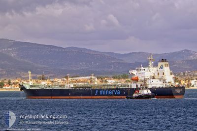
MINERVA GRACE
Oil/Chemical Tanker
Current Trip
FOR ORDERS
| Time Travelled | 24 days |
|---|---|
| Remaining Time | --- |
| Distance Travelled | 1068.07 nm |
| Remaining Distance | --- |
| AVG Speed | 7.5 Knop |
| MAX Speed | 14.3 Knop |
| AVG Wind | 11.5 knots |
| MAX Wind | 34 knots |
| MIN Temp | 8.9°C / 48.02°F |
| MAX Temp | 16.7°C / 62.06°F |
| Djupgående | 7.7 m |
| Position mottagen | 5 m sen |
Current Position
| Longitud | --- |
|---|---|
| Latitude | --- |
| Status | Under way using engine |
| Fart | 0.5 Knop |
| Kurs | 299° |
| Område | Aegean Sea |
| Station | T-AIS |
| Position mottagen | 5 m sen |
Info
Information
The current position of MINERVA GRACE is in Aegean Sea with coordinates 37.30361° / 24.06605° as reported on 2025-01-27 07:22 by AIS to our vessel tracker app. The vessel's current speed is 0.5 Knop
The vessel MINERVA GRACE (IMO: 9305855, MMSI: 215926000) is a Oil/Chemical Tanker that was built in 2005 ( 20 År gammal ). It's sailing under the flag of [MT] Malta.
In this page you can find informations about the vessels current position, last detected port calls, and current voyage information. If the vessels is not in coverage by AIS you will find the latest position.
The current position of MINERVA GRACE is detected by our AIS receivers and we are not responsible for the reliability of the data. The last position was recorded while the vessel was in Coverage by the Ais receivers of our vessel tracking app.
The current draught of MINERVA GRACE as reported by AIS is 7.7 meters
Weather
| Temperature | 14.7°C / 58.46°F |
|---|---|
| Wind Speed | 9 knots |
| Direction | 200° SSW |
| Pressure | 1022.6 hPa |
| Humidity | 76.9 % |
| Cloud Coverage | 100 % |
Featured Company
Last Port Calls
| Port | Arrival | Departure | Time In Port |
|---|---|---|---|
| 2024-12-31 10:00 | 2025-01-02 15:05 | 2 d | |
| 2024-12-20 16:29 | 2024-12-22 23:57 | 2 d | |
| 2024-11-26 11:12 | 2024-11-27 17:46 | 1 d | |
| 2024-11-17 07:01 | 2024-11-17 18:08 | 11 h | |
| 2024-11-17 05:48 | |||
| 2024-11-02 08:46 |
Most Visited Ports (Last year)
| Port | Arrivals | |
|---|---|---|
| 5 | ||
| 3 | ||
| 3 | ||
| 3 | ||
| 2 | ||
| 2 |
Last Trips
| Origin | Departure | Destination | Arrival | Distance | |
|---|---|---|---|---|---|
| 2024-12-23 02:57 | 2024-12-31 12:00 | 378.43 nm | |||
| 2024-11-27 20:46 | 2024-12-20 19:29 | 690.02 nm | |||
| 2024-11-17 21:08 | 2024-11-26 14:12 | 647.28 nm | |||
| 2024-11-17 08:48 | 2024-11-17 10:01 | 28.15 nm |
Events
| Tid | Event | Detaljer | Position / Dest | Information |
|---|---|---|---|---|
| 2025-01-26 15:25 | STOPPAR förflyttning | 19.56 nm, West of KYTHNOS |
37.28747 / 24.00660
FOR ORDERS
|
Fart: 0.3 kn Kurs: 137° |
| 2025-01-26 07:05 | STARTAR förflyttning |
36.89764 / 23.84243
FOR ORDERS
|
Fart: 3.4 kn Kurs: 53° |
|
| 2025-01-26 05:44 | Status ändrad | Under way using engine Default |
36.92764 / 23.83833
FOR ORDERS
|
Fart: 1.1 kn Kurs: 98° |
| 2025-01-26 05:44 | I täckningsområde |
36.92693 / 23.83837
Aegean Sea
|
Fart: 1.1 kn Kurs: 177.1° |
|
| 2025-01-26 03:54 | Status ändrad | Default Under way using engine |
36.96347 / 23.83228
FOR ORDERS
|
Fart: 1.2 kn Kurs: 104° |
| 2025-01-26 03:51 | UTANFÖR täckningsområde |
36.96450 / 23.83205
Aegean Sea
|
Fart: 1.2 kn Kurs: 170.1° |
|
| 2025-01-26 03:46 | Status ändrad | Under way using engine Default |
36.96614 / 23.83168
FOR ORDERS
|
Fart: 1.1 kn Kurs: 102° |
| 2025-01-26 03:40 | Status ändrad | Default Under way using engine |
36.96823 / 23.83121
FOR ORDERS
|
Fart: 1.2 kn Kurs: 105° |
| 2025-01-26 01:30 | Status ändrad | Under way using engine Default |
37.01293 / 23.82735
FOR ORDERS
|
Fart: 1.2 kn Kurs: 126° |
| 2025-01-26 01:20 | Status ändrad | Default Under way using engine |
37.01646 / 23.82874
FOR ORDERS
|
Fart: 1.2 kn Kurs: 126° |