
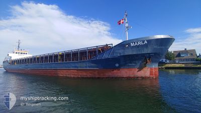
MARLA
General Cargo
Current Trip
| Time Travelled | 1 day |
|---|---|
| Remaining Time | 4 h, 40 mins |
| Distance Travelled | 235.49 nm |
| Remaining Distance | 23.15 nm |
| AVG Speed | 6.1 Knop |
| MAX Speed | 7.9 Knop |
| AVG Wind | 10.4 knots |
| MAX Wind | 19 knots |
| MIN Temp | -1.5°C / 29.3°F |
| MAX Temp | 5.9°C / 42.62°F |
| Djupgående | 3.7 m |
| Position mottagen | 2 m sen |
Current Position
| Longitud | --- |
|---|---|
| Latitude | --- |
| Status | Under way using engine |
| Fart | 5 Knop |
| Kurs | 125.7° |
| Område | North Sea |
| Station | T-AIS |
| Position mottagen | 2 m sen |
Info
Information
The current position of MARLA is in North Sea with coordinates 53.74456° / 9.40910° as reported on 2025-03-17 08:43 by AIS to our vessel tracker app. The vessel's current speed is 5 Knop and is heading at the port of HAMBURG. The estimated time of arrival as calculated by MyShipTracking vessel tracking app is 2025-03-17 14:25 LT
The vessel MARLA (IMO: 8611013, MMSI: 305661000) is a General Cargo that was built in 1987 ( 38 År gammal ). It's sailing under the flag of [AG] Antigua Barbuda.
In this page you can find informations about the vessels current position, last detected port calls, and current voyage information. If the vessels is not in coverage by AIS you will find the latest position.
The current position of MARLA is detected by our AIS receivers and we are not responsible for the reliability of the data. The last position was recorded while the vessel was in Coverage by the Ais receivers of our vessel tracking app.
The current draught of MARLA as reported by AIS is 3.7 meters
Weather
| Temperature | 2.4°C / 36.32°F |
|---|---|
| Wind Speed | 9 knots |
| Direction | 57° ENE |
| Pressure | 1031.8 hPa |
| Humidity | 55.1 % |
| Cloud Coverage | --- |
Featured Company
Last Port Calls
| Port | Arrival | Departure | Time In Port |
|---|---|---|---|
| 2025-03-15 04:42 | 2025-03-15 20:42 | 15 h | |
| 2025-03-07 01:47 | 2025-03-07 12:09 | 10 h | |
| 2025-03-05 06:52 | 2025-03-06 10:49 | 1 d | |
| 2025-03-03 09:41 | 2025-03-04 16:10 | 1 d | |
| 2025-02-25 23:35 | 2025-02-28 13:07 | 2 d | |
| 2025-02-24 07:29 | 2025-02-24 17:40 | 10 h | |
| 2025-02-19 13:26 | 2025-02-22 11:43 | 2 d | |
| 2025-02-16 01:34 | 2025-02-17 12:49 | 1 d | |
| 2025-02-11 22:50 | 2025-02-13 22:22 | 1 d | |
| 2025-02-06 12:57 | 2025-02-10 15:22 | 4 d |
Last Trips
| Origin | Departure | Destination | Arrival | Distance | |
|---|---|---|---|---|---|
| 2025-03-07 12:09 | 2025-03-15 04:42 | 579.01 nm | |||
| 2025-03-06 10:49 | 2025-03-07 01:47 | 96.75 nm | |||
| 2025-03-04 16:10 | 2025-03-05 06:52 | 71.63 nm | |||
| 2025-02-28 13:07 | 2025-03-03 09:41 | 420.46 nm | |||
| 2025-02-24 17:40 | 2025-02-25 23:35 | 202.86 nm | |||
| 2025-02-22 11:43 | 2025-02-24 07:29 | 277.47 nm | |||
| 2025-02-17 12:49 | 2025-02-19 13:26 | 325.31 nm | |||
| 2025-02-13 22:22 | 2025-02-16 01:34 | 365.26 nm | |||
| 2025-02-10 15:22 | 2025-02-11 22:50 | 198.73 nm | |||
| 2025-02-05 16:12 | 2025-02-06 12:57 | 154.19 nm |
Events
| Tid | Event | Detaljer | Position / Dest | Information |
|---|---|---|---|---|
| 2025-03-17 05:40 | Byter havsområde | German part of the North Sea German part of the Baltic Sea |
53.88849 / 9.13632
North Sea
DEHAM
|
Fart: 6.6 kn Kurs: 207.3° |
| 2025-03-17 05:38 | STARTAR förflyttning | 0.99 nm, South West of BRUNSBUETTEL |
53.89152 / 9.13988
DEHAM
|
Fart: 5.2 kn Kurs: 222.6° |
| 2025-03-17 05:34 | Status ändrad | Under way using engine Default |
53.89424 / 9.14528
DEHAM
|
Fart: Kurs: 228° |
| 2025-03-17 05:18 | Status ändrad | Default Under way using engine |
53.89425 / 9.14544
DEHAM
|
Fart: Kurs: 229° |
| 2025-03-17 05:10 | STOPPAR förflyttning | 0.73 nm, South West of BRUNSBUETTEL |
53.89429 / 9.14547
DEHAM
|
Fart: 0.1 kn Kurs: 226° |
| 2025-03-17 04:27 | STARTAR förflyttning | 1.82 nm, North East of OSTERMOOR |
53.94192 / 9.22249
DEHAM
|
Fart: 4.6 kn Kurs: 212° |
| 2025-03-17 04:17 | STOPPAR förflyttning | 1.94 nm, North East of OSTERMOOR |
53.94344 / 9.22453
DEHAM
|
Fart: 0.3 kn Kurs: 222° |
| 2025-03-17 02:22 | Status ändrad | Under way using engine Default |
54.14096 / 9.34290
DEHAM
|
Fart: 7 kn Kurs: 236° |
| 2025-03-17 02:17 | Status ändrad | Default Under way using engine |
54.14640 / 9.35409
DEHAM
|
Fart: 6.9 kn Kurs: 237.8° |
| 2025-03-16 22:18 | STARTAR förflyttning | 7.28 nm, West of KIEL |
54.34195 / 9.95317
DEHAM
|
Fart: 3.2 kn Kurs: 258° |