
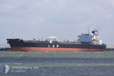
M/T RED DIAMOND
Oil/Chemical Tanker
Current Trip
| Time Travelled | 1 day |
|---|---|
| Remaining Time | 1 day |
| Distance Travelled | 502.92 nm |
| Remaining Distance | 492.98 nm |
| AVG Speed | 24.3 Knop |
| MAX Speed | 24.3 Knop |
| AVG Wind | 10.7 knots |
| MAX Wind | 20.1 knots |
| MIN Temp | 17.7°C / 63.86°F |
| MAX Temp | 24.5°C / 76.1°F |
| Djupgående | 8.8 m |
| Position mottagen | 3 m sen |
Current Position
| Longitud | 24.17942° |
|---|---|
| Latitude | 34.66265° |
| Status | Under way using engine |
| Fart | 13.9 Knop |
| Kurs | 272.6° |
| Område | Mediterranean Sea - Eastern Basin |
| Station | T-AIS |
| Position mottagen | 3 m sen |
Info
Information
The current position of M/T RED DIAMOND is in Mediterranean Sea - Eastern Basin with coordinates 34.66265° / 24.17942° as reported on 2024-04-28 02:29 by AIS to our vessel tracker app. The vessel's current speed is 13.9 Knop and is heading at the port of TARANTO. The estimated time of arrival as calculated by MyShipTracking vessel tracking app is 2024-04-29 14:30 LT
The vessel M/T RED DIAMOND (IMO: 9583665, MMSI: 256480000) is a Oil/Chemical Tanker that was built in 2012 ( 12 År gammal ). It's sailing under the flag of [MT] Malta.
In this page you can find informations about the vessels current position, last detected port calls, and current voyage information. If the vessels is not in coverage by AIS you will find the latest position.
The current position of M/T RED DIAMOND is detected by our AIS receivers and we are not responsible for the reliability of the data. The last position was recorded while the vessel was in Coverage by the Ais receivers of our vessel tracking app.
The current draught of M/T RED DIAMOND as reported by AIS is 8.8 meters
Weather
| Temperature | 18.4°C / 65.12°F |
|---|---|
| Wind Speed | 12 knots |
| Direction | 23° NNE |
| Pressure | 1014.7 hPa |
| Humidity | 66.3 % |
| Cloud Coverage | --- |
Featured Company
Last Port Calls
| Port | Arrival | Departure | Time In Port |
|---|---|---|---|
| 2024-04-26 01:10 | 2024-04-26 03:28 | 2 h | |
| 2024-04-06 22:03 | 2024-04-09 19:49 | 2 d | |
| 2024-03-28 23:05 | 2024-03-31 17:46 | 2 d | |
| 2024-03-09 17:14 | 2024-03-13 18:02 | 4 d | |
| 2024-03-06 04:23 | 2024-03-08 17:52 | 2 d | |
| 2024-02-24 04:38 | 2024-02-27 03:25 | 2 d | |
| 2024-02-17 11:23 | 2024-02-19 14:48 | 2 d | |
| 2024-02-05 17:58 | 2024-02-10 04:50 | 4 d |
Last Trips
| Origin | Departure | Destination | Arrival | Distance | |
|---|---|---|---|---|---|
| 2024-04-09 21:49 | 2024-04-26 04:10 | 2507.50 nm | |||
| 2024-03-31 19:46 | 2024-04-07 00:03 | 1457.81 nm | |||
| 2024-03-13 19:02 | 2024-03-29 00:05 | 193.92 nm | |||
| 2024-03-08 18:52 | 2024-03-09 18:14 | 260.31 nm | |||
| 2024-02-27 04:25 | 2024-03-06 05:23 | 294.77 nm | |||
| 2024-02-19 15:48 | 2024-02-24 05:38 | 639.72 nm | |||
| 2024-02-10 05:50 | 2024-02-17 12:23 | 1873.61 nm | |||
| 2024-01-30 06:33 | 2024-02-05 18:58 | 638.39 nm |
Events
| Tid | Event | Detaljer | Position / Dest | Information |
|---|---|---|---|---|
| 2024-04-28 02:12 | Status ändrad | Under way using engine Default |
34.65927 / 24.25890
CYVAS>ITTAR
|
Fart: 14 kn Kurs: 269° |
| 2024-04-28 01:36 | Status ändrad | Default Under way using engine |
34.65667 / 24.42833
CYVAS>ITTAR
|
Fart: 13.8 kn Kurs: 269.7° |
| 2024-04-28 01:21 | Status ändrad | Under way using engine Default |
34.65824 / 24.49634
CYVAS>ITTAR
|
Fart: 13.7 kn Kurs: 272° |
| 2024-04-28 01:19 | I täckningsområde |
34.65824 / 24.49634
Mediterranean Sea - Eastern Basin
CYVAS>ITTAR
|
Fart: 13.8 kn Kurs: 270.5° |
|
| 2024-04-28 00:36 | Status ändrad | Default Under way using engine |
34.65333 / 24.70667
CYVAS>ITTAR
|
Fart: 13.7 kn Kurs: 270.5° |
| 2024-04-28 00:17 | Status ändrad | Under way using engine Default |
34.65252 / 24.79371
CYVAS>ITTAR
|
Fart: 13.5 kn Kurs: 274° |
| 2024-04-28 00:17 | UTANFÖR täckningsområde |
34.65252 / 24.79371
Mediterranean Sea - Eastern Basin
CYVAS>ITTAR
|
Fart: 13.7 kn Kurs: 270.5° |
|
| 2024-04-27 23:50 | Status ändrad | Default Under way using engine |
34.65003 / 24.91765
CYVAS>ITTAR
|
Fart: 13.7 kn Kurs: 273.8° |
| 2024-04-27 23:27 | Status ändrad | Under way using engine Default |
34.64444 / 25.02095
CYVAS>ITTAR
|
Fart: 13.8 kn Kurs: 272° |
| 2024-04-27 23:05 | Status ändrad | Default Under way using engine |
34.63969 / 25.12641
CYVAS>ITTAR
|
Fart: 14 kn Kurs: 271.8° |