
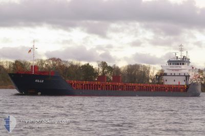
KILLU
General Cargo
Current Trip
| Time Travelled | 6 days |
|---|---|
| Remaining Time | 1 day |
| Distance Travelled | 1427.46 nm |
| Remaining Distance | 390.93 nm |
| AVG Speed | 9.4 Knop |
| MAX Speed | 14 Knop |
| AVG Wind | 14.4 knots |
| MAX Wind | 33.3 knots |
| MIN Temp | 2.7°C / 36.86°F |
| MAX Temp | 10.4°C / 50.72°F |
| Djupgående | 6.6 m |
| Position mottagen | 18 m sen |
Current Position
| Longitud | --- |
|---|---|
| Latitude | --- |
| Status | Under way using engine |
| Fart | 10.9 Knop |
| Kurs | 36.6° |
| Område | Baltic Sea |
| Station | T-AIS |
| Position mottagen | 18 m sen |
Info
Information
The current position of KILLU is in Baltic Sea with coordinates 57.43578° / 19.37623° as reported on 2025-12-05 23:32 by AIS to our vessel tracker app. The vessel's current speed is 10.9 Knop and is heading at the port of ST PETERSBURG. The estimated time of arrival as calculated by MyShipTracking vessel tracking app is 2025-12-07 15:14 LT
The vessel KILLU (IMO: 9454826, MMSI: 304625000) is a General Cargo that was built in 2009 ( 16 År gammal ). It's sailing under the flag of [AG] Antigua Barbuda.
In this page you can find informations about the vessels current position, last detected port calls, and current voyage information. If the vessels is not in coverage by AIS you will find the latest position.
The current position of KILLU is detected by our AIS receivers and we are not responsible for the reliability of the data. The last position was recorded while the vessel was in Coverage by the Ais receivers of our vessel tracking app.
The current draught of KILLU as reported by AIS is 6.6 meters
Weather
| Temperature | 7.1°C / 44.78°F |
|---|---|
| Wind Speed | 16 knots |
| Direction | 143° SE |
| Pressure | 1015.6 hPa |
| Humidity | 94 % |
| Cloud Coverage | 100 % |
Featured Company
Last Port Calls
| Port | Arrival | Departure | Time In Port |
|---|---|---|---|
| 2025-11-27 05:12 | 2025-11-29 20:45 | 2 d | |
| 2025-11-20 17:04 | 2025-11-23 15:04 | 2 d | |
| 2025-11-09 18:17 | 2025-11-11 12:30 | 1 d | |
| 2025-11-03 16:17 | 2025-11-06 10:13 | 2 d | |
| 2025-10-30 14:22 | 2025-11-01 21:20 | 2 d | |
| 2025-10-26 10:50 | 2025-10-28 20:36 | 2 d | |
| 2025-10-20 00:54 | 2025-10-22 15:16 | 2 d | |
| 2025-10-16 03:16 | 2025-10-17 04:34 | 1 d | |
| 2025-10-11 17:20 | 2025-10-12 20:34 | 1 d | |
| 2025-10-03 08:26 | 2025-10-06 09:17 | 3 d |
Most Visited Ports (Last year)
| Port | Arrivals | |
|---|---|---|
| 5 | ||
| 3 | ||
| 3 | ||
| 3 | ||
| 2 | ||
| 2 |
Last Trips
| Origin | Departure | Destination | Arrival | Distance | |
|---|---|---|---|---|---|
| 2025-11-23 15:04 | 2025-11-27 05:12 | 681.28 nm | |||
| 2025-11-11 12:30 | 2025-11-20 17:04 | 1859.21 nm | |||
| 2025-11-06 10:13 | 2025-11-09 18:17 | 875.29 nm | |||
| 2025-11-01 21:20 | 2025-11-03 16:17 | 467.68 nm | |||
| 2025-10-28 20:36 | 2025-10-30 14:22 | 489.40 nm | |||
| 2025-10-22 15:16 | 2025-10-26 10:50 | 533.06 nm | |||
| 2025-10-17 04:34 | 2025-10-20 00:54 | 120.38 nm | |||
| 2025-10-12 20:34 | 2025-10-16 03:16 | 761.43 nm | |||
| 2025-10-06 09:17 | 2025-10-11 17:20 | 465.34 nm | |||
| 2025-09-21 20:39 | 2025-10-03 08:26 | 2196.88 nm |
Events
| Tid | Event | Detaljer | Position / Dest | Information |
|---|---|---|---|---|
| 2025-12-05 23:37 | Status ändrad | Default Under way using engine |
57.44767 / 19.39256
RULED
|
Fart: 10.9 kn Kurs: 36.6° |
| 2025-12-05 21:37 | Status ändrad | Under way using engine Default |
57.16212 / 18.99056
RULED
|
Fart: 10.7 kn Kurs: 36° |
| 2025-12-05 21:33 | Status ändrad | Default Under way using engine |
57.15240 / 18.97759
RULED
|
Fart: 10.6 kn Kurs: 37.2° |
| 2025-12-05 21:27 | Status ändrad | Under way using engine Default |
57.13816 / 18.95804
RULED
|
Fart: 10.7 kn Kurs: 38° |
| 2025-12-05 21:21 | Status ändrad | Default Under way using engine |
57.12441 / 18.93846
RULED
|
Fart: 10.7 kn Kurs: 38° |
| 2025-12-05 20:45 | Status ändrad | Under way using engine Default |
57.03623 / 18.81901
RULED
|
Fart: 10.6 kn Kurs: 36° |
| 2025-12-05 20:37 | Status ändrad | Default Under way using engine |
57.01798 / 18.79418
RULED
|
Fart: 10.7 kn Kurs: 38.9° |
| 2025-12-05 20:26 | Status ändrad | Under way using engine Default |
56.99191 / 18.75824
RULED
|
Fart: 10.8 kn Kurs: 37° |
| 2025-12-05 19:57 | Status ändrad | Default Under way using engine |
56.92416 / 18.66031
RULED
|
Fart: 10.7 kn Kurs: 38° |
| 2025-12-05 19:51 | Byter havsområde | Swedish part of the Baltic Sea Danish part of the Kattegat |
56.91176 / 18.64190
Baltic Sea
RULED
|
Fart: 10.7 kn Kurs: 38° |