
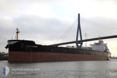
JOHN M CARRAS
Bulk Carrier
Current Trip
| Time Travelled | 8 days |
|---|---|
| Remaining Time | --- |
| Distance Travelled | 2596.86 nm |
| Remaining Distance | --- |
| AVG Speed | 12.8 Knop |
| MAX Speed | 15.4 Knop |
| AVG Wind | 12 knots |
| MAX Wind | 24 knots |
| MIN Temp | 12°C / 53.6°F |
| MAX Temp | 20.7°C / 69.26°F |
| Djupgående | 12.3 m |
| Position mottagen | 1 d sen |
Current Position
| Longitud | -16.81651° |
|---|---|
| Latitude | 26.87938° |
| Status | Under way using engine |
| Fart | 12.5 Knop |
| Kurs | 194.5° |
| Område | North Atlantic Ocean |
| Station | T-AIS |
| Position mottagen | 1 d sen |
Info
Information
The current position of JOHN M CARRAS is in North Atlantic Ocean with coordinates 26.87938° / -16.81651° as reported on 2024-05-21 23:31 by AIS to our vessel tracker app. The vessel's current speed is 12.5 Knop and is heading at the port of SINGAPORE. The estimated time of arrival as calculated by MyShipTracking vessel tracking app is 2024-06-23 18:00 LT
The vessel JOHN M CARRAS (IMO: 9592707, MMSI: 241150000) is a Bulk Carrier that was built in 2012 ( 12 År gammal ). It's sailing under the flag of [GR] Greece.
In this page you can find informations about the vessels current position, last detected port calls, and current voyage information. If the vessels is not in coverage by AIS you will find the latest position.
The current position of JOHN M CARRAS is detected by our AIS receivers and we are not responsible for the reliability of the data. The last position was recorded while the vessel was in Coverage by the Ais receivers of our vessel tracking app.
The current draught of JOHN M CARRAS as reported by AIS is 12.3 meters
Weather
| Temperature | 19.1°C / 66.38°F |
|---|---|
| Wind Speed | 21 knots |
| Direction | 25° NNE |
| Pressure | 1016.3 hPa |
| Humidity | 84.4 % |
| Cloud Coverage | 2 % |
Featured Company
Last Port Calls
| Port | Arrival | Departure | Time In Port |
|---|---|---|---|
| 2024-05-05 17:16 | 2024-05-14 22:22 | 9 d | |
| 2024-04-18 08:17 | 2024-04-22 18:38 | 4 d | |
| 2024-04-11 16:35 | 2024-04-16 10:22 | 4 d | |
| 2024-03-14 04:49 | 2024-03-17 18:30 | 3 d |
Most Visited Ports (Last year)
| Port | Arrivals | |
|---|---|---|
| 2 | ||
| 2 | ||
| 1 | ||
| 1 | ||
| 1 | ||
| 1 |
Last Trips
| Origin | Departure | Destination | Arrival | Distance | |
|---|---|---|---|---|---|
| 2024-04-22 18:38 | 2024-05-05 17:16 | 1088.28 nm | |||
| 2024-04-16 10:22 | 2024-04-18 08:17 | 510.27 nm | |||
| 2024-03-17 18:30 | 2024-04-11 16:35 | 6779.04 nm | |||
| 2024-01-31 14:33 | 2024-03-14 04:49 | 11231.73 nm |
Events
| Tid | Event | Detaljer | Position / Dest | Information |
|---|---|---|---|---|
| 2024-05-21 23:31 | UTANFÖR täckningsområde |
26.87938 / -16.81651
North Atlantic Ocean
|
Fart: 12.5 kn Kurs: 194.5° |
|
| 2024-05-21 12:10 | ETA ändrat | 2024/06/23 10:00 2024/06/23 06:00 |
29.03620 / -15.49136
SG SIN
|
Fart: 13.1 kn Kurs: 197.9° |
| 2024-05-21 11:54 | Status ändrad | Under way using engine Default |
29.08460 / -15.47358
SG SIN
|
Fart: 13.1 kn Kurs: 197° |
| 2024-05-21 11:51 | Status ändrad | Default Under way using engine |
29.09799 / -15.46899
SG SIN
|
Fart: 13.1 kn Kurs: 196.8° |
| 2024-05-21 11:39 | Status ändrad | Under way using engine Default |
29.13612 / -15.45552
SG SIN
|
Fart: 13.1 kn Kurs: 197° |
| 2024-05-21 11:38 | Status ändrad | Default Under way using engine |
29.14024 / -15.45407
SG SIN
|
Fart: 13 kn Kurs: 197.3° |
| 2024-05-21 11:14 | Status ändrad | Under way using engine Default |
29.22323 / -15.42393
SG SIN
|
Fart: 12.9 kn Kurs: 197° |
| 2024-05-21 11:10 | Status ändrad | Default Under way using engine |
29.23820 / -15.41883
SG SIN
|
Fart: 13 kn Kurs: 196.4° |
| 2024-05-21 11:06 | Upptäckt i hav | Spanish (Canary Islands) part of the North Atlantic Ocean |
29.25322 / -15.41353
North Atlantic Ocean
|
Fart: 13 kn Kurs: 196.4° |
| 2024-05-21 11:06 | Status ändrad | Under way using engine Default |
29.25322 / -15.41353
SG SIN
|
Fart: 12.9 kn Kurs: 196° |