
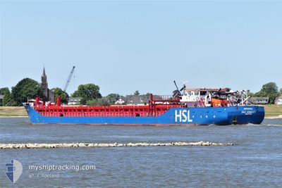
H&S HONESTY
General Cargo
Current Trip
ESM R
| Time Travelled | 4 days |
|---|---|
| Remaining Time | --- |
| Distance Travelled | 753.87 nm |
| Remaining Distance | --- |
| AVG Speed | 9.2 Knop |
| MAX Speed | 13.7 Knop |
| AVG Wind | 12.4 knots |
| MAX Wind | 27 knots |
| MIN Temp | 12°C / 53.6°F |
| MAX Temp | 19.3°C / 66.74°F |
| Djupgående | 4.1 m |
| Position mottagen | 8 h, 21 m sen |
Current Position
| Longitud | -8.75722° |
|---|---|
| Latitude | 45.07139° |
| Status | Under way sailing |
| Fart | 9.2 Knop |
| Kurs | 210° |
| Område | North Atlantic Ocean |
| Station | T-AIS |
| Position mottagen | 8 h, 21 m sen |
Info
Information
The current position of H&S HONESTY is in North Atlantic Ocean with coordinates 45.07139° / -8.75722° as reported on 2024-05-13 14:11 by AIS to our vessel tracker app. The vessel's current speed is 9.2 Knop
The vessel H&S HONESTY (IMO: 9421611, MMSI: 245407000) is a General Cargo that was built in 2007 ( 17 År gammal ). It's sailing under the flag of [NL] Netherlands.
In this page you can find informations about the vessels current position, last detected port calls, and current voyage information. If the vessels is not in coverage by AIS you will find the latest position.
The current position of H&S HONESTY is detected by our AIS receivers and we are not responsible for the reliability of the data. The last position was recorded while the vessel was in Coverage by the Ais receivers of our vessel tracking app.
The current draught of H&S HONESTY as reported by AIS is 4.1 meters
Weather
| Temperature | 13.5°C / 56.3°F |
|---|---|
| Wind Speed | 23 knots |
| Direction | 281° W |
| Pressure | 1010 hPa |
| Humidity | 86.1 % |
| Cloud Coverage | 72 % |
Featured Company
Last Port Calls
| Port | Arrival | Departure | Time In Port |
|---|---|---|---|
| 2024-05-06 16:39 | 2024-05-09 17:43 | 3 d | |
| 2024-05-01 13:22 | 2024-05-03 11:58 | 1 d | |
| 2024-04-30 03:18 | 2024-04-30 13:35 | 10 h | |
| 2024-04-26 19:02 | 2024-04-29 20:44 | 3 d | |
| 2024-04-24 06:59 | 2024-04-25 18:41 | 1 d | |
| 2024-04-21 22:39 | 2024-04-22 23:22 | 1 d | |
| 2024-04-13 06:54 | 2024-04-16 18:20 | 3 d | |
| 2024-04-10 11:37 | 2024-04-10 20:59 | 9 h | |
| 2024-04-02 23:26 | 2024-04-04 21:38 | 1 d | |
| 2024-04-02 11:41 | 2024-04-02 20:25 | 8 h |
Last Trips
| Origin | Departure | Destination | Arrival | Distance | |
|---|---|---|---|---|---|
| 2024-05-03 13:58 | 2024-05-06 18:39 | 326.83 nm | |||
| 2024-04-30 15:35 | 2024-05-01 15:22 | 247.53 nm | |||
| 2024-04-29 22:44 | 2024-04-30 05:18 | 64.62 nm | |||
| 2024-04-25 19:41 | 2024-04-26 21:02 | 228.58 nm | |||
| 2024-04-23 00:22 | 2024-04-24 07:59 | 213.14 nm | |||
| 2024-04-16 19:20 | 2024-04-21 23:39 | 973.47 nm | |||
| 2024-04-10 22:59 | 2024-04-13 07:54 | 573.95 nm | |||
| 2024-04-04 23:38 | 2024-04-10 13:37 | 1078.99 nm | |||
| 2024-04-02 22:25 | 2024-04-03 01:26 | 25.41 nm | |||
| 2024-03-29 16:38 | 2024-04-02 13:41 | 272.93 nm |
Events
| Tid | Event | Detaljer | Position / Dest | Information |
|---|---|---|---|---|
| 2024-05-13 14:15 | Status ändrad | Default Under way sailing |
45.06167 / -8.76333
ESM R
|
Fart: 9.2 kn Kurs: 210° |
| 2024-05-13 14:11 | Status ändrad | Under way sailing Default |
45.07139 / -8.75722
ESM R
|
Fart: 9 kn Kurs: 209° |
| 2024-05-13 14:11 | UTANFÖR täckningsområde |
45.07139 / -8.75722
North Atlantic Ocean
ESM R
|
Fart: 9.2 kn Kurs: 210° |
|
| 2024-05-13 14:09 | Status ändrad | Default Under way sailing |
45.07500 / -8.75333
ESM R
|
Fart: 8.6 kn Kurs: 207.8° |
| 2024-05-13 12:13 | Byter havsområde | Spanish part of the North Atlantic Ocean French part of the Celtic Sea |
45.32163 / -8.56393
North Atlantic Ocean
ESM R
|
Fart: 8.2 kn Kurs: 205.5° |
| 2024-05-13 12:13 | Status ändrad | Under way sailing Default |
45.32163 / -8.56393
ESM R
|
Fart: 8 kn Kurs: 207° |
| 2024-05-13 12:00 | I täckningsområde |
45.32163 / -8.56393
North Atlantic Ocean
ESM R
|
Fart: 8.2 kn Kurs: 205.5° |
|
| 2024-05-12 20:11 | Status ändrad | Default Under way sailing |
47.33579 / -6.97269
ESM R
|
Fart: 9.8 kn Kurs: 211.2° |
| 2024-05-12 20:09 | UTANFÖR täckningsområde |
47.34002 / -6.96916
Celtic Sea
ESM R
|
Fart: 9.8 kn Kurs: 211.2° |
|
| 2024-05-12 19:58 | Status ändrad | Under way sailing Default |
47.36692 / -6.94673
ESM R
|
Fart: 9 kn Kurs: 208° |