
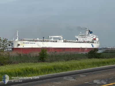
HELLESPONT PROTECTOR
Crude Oil Tanker
Current Trip
| Time Travelled | 2 days |
|---|---|
| Remaining Time | --- |
| Distance Travelled | 274.79 nm |
| Remaining Distance | --- |
| AVG Speed | 9.7 Knop |
| MAX Speed | 15.3 Knop |
| AVG Wind | 12.9 knots |
| MAX Wind | 33 knots |
| MIN Temp | 7.6°C / 45.68°F |
| MAX Temp | 15.9°C / 60.62°F |
| Djupgående | 9.3 m |
| Position mottagen | 16 h, 28 m sen |
Current Position
| Longitud | --- |
|---|---|
| Latitude | --- |
| Status | Under way using engine |
| Fart | 13.1 Knop |
| Kurs | 79° |
| Område | Alboran Sea |
| Station | T-AIS |
| Position mottagen | 16 h, 28 m sen |
Info
Information
The current position of HELLESPONT PROTECTOR is in Alboran Sea with coordinates 36.06927° / -4.29820° as reported on 2026-03-05 18:18 by AIS to our vessel tracker app. The vessel's current speed is 13.1 Knop and is heading at the port of BOZCAADA. The estimated time of arrival as calculated by MyShipTracking vessel tracking app is 2026-03-12 14:00 LT
The vessel HELLESPONT PROTECTOR (IMO: 9351452, MMSI: 232012083) is a Crude Oil Tanker that was built in 2007 ( 19 År gammal ). It's sailing under the flag of [GB] United Kingdom.
In this page you can find informations about the vessels current position, last detected port calls, and current voyage information. If the vessels is not in coverage by AIS you will find the latest position.
The current position of HELLESPONT PROTECTOR is detected by our AIS receivers and we are not responsible for the reliability of the data. The last position was recorded while the vessel was in Coverage by the Ais receivers of our vessel tracking app.
The current draught of HELLESPONT PROTECTOR as reported by AIS is 9.3 meters
Weather
| Temperature | 14.1°C / 57.38°F |
|---|---|
| Wind Speed | 26 knots |
| Direction | 257° WSW |
| Pressure | 1012.7 hPa |
| Humidity | 79.9 % |
| Cloud Coverage | 99 % |
Featured Company
Last Port Calls
| Port | Arrival | Departure | Time In Port |
|---|---|---|---|
| 2026-03-01 07:29 | 2026-03-04 01:17 | 2 d | |
| 2026-02-03 17:39 | 2026-02-05 21:43 | 2 d | |
| 2026-01-10 20:17 | 2026-01-16 09:57 | 5 d | |
| 2026-01-04 01:55 | 2026-01-04 05:55 | 4 h | |
| 2026-01-02 09:02 | 2026-01-03 23:26 | 1 d | |
| 2026-01-02 05:26 |
Most Visited Ports (Last year)
| Port | Arrivals | |
|---|---|---|
| 3 | ||
| 3 | ||
| 2 | ||
| 2 | ||
| 1 | ||
| 1 |
Last Trips
| Origin | Departure | Destination | Arrival | Distance | |
|---|---|---|---|---|---|
| 2026-02-05 21:43 | 2026-03-01 07:29 | 5101.69 nm | |||
| 2026-01-16 09:57 | 2026-02-03 17:39 | 4334.20 nm | |||
| 2026-01-04 05:55 | 2026-01-10 20:17 | 463.24 nm | |||
| 2026-01-03 23:26 | 2026-01-04 01:55 | 29.55 nm | |||
| 2026-01-02 05:26 | 2026-01-02 09:02 | 30.43 nm |
Events
| Tid | Event | Detaljer | Position / Dest | Information |
|---|---|---|---|---|
| 2026-03-05 18:23 | Status ändrad | Default Under way using engine |
36.07250 / -4.27432
TRBZC
|
Fart: 13.1 kn Kurs: 79° |
| 2026-03-05 18:18 | UTANFÖR täckningsområde |
36.06927 / -4.29820
Alboran Sea
TRBZC
|
Fart: 13.1 kn Kurs: 79° |
|
| 2026-03-05 18:16 | Status ändrad | Under way using engine Default |
36.06833 / -4.30487
TRBZC
|
Fart: 13.1 kn Kurs: 79° |
| 2026-03-05 18:11 | Status ändrad | Default Under way using engine |
36.06515 / -4.32752
TRBZC
|
Fart: 13.3 kn Kurs: 86° |
| 2026-03-05 14:56 | Byter havsområde | Spanish part of the Alboran Sea Gibraltarian part of the Alboran Sea |
36.01237 / -5.24475
Alboran Sea
TRBZC
|
Fart: 14.4 kn Kurs: 117° |
| 2026-03-05 14:35 | Byter havsområde | Gibraltarian part of the Alboran Sea Gibraltarian part of the Strait of Gibraltar |
36.06120 / -5.32585
Alboran Sea
TRBZC
|
Fart: 13.4 kn Kurs: 120° |
| 2026-03-05 14:17 | Byter havsområde | Gibraltarian part of the Strait of Gibraltar Spanish part of the Strait of Gibraltar |
36.09757 / -5.38472
Strait of Gibraltar
TRBZC
|
Fart: 11.6 kn Kurs: 144° |
| 2026-03-05 14:01 | STARTAR förflyttning | --- |
36.13082 / -5.40892
TRBZC
|
Fart: 3.1 kn Kurs: 137° |
| 2026-03-05 13:49 | Status ändrad | Under way using engine At anchor |
36.13415 / -5.40810
TRBZC
|
Fart: 0.7 kn Kurs: 247° |
| 2026-03-05 12:17 | Djupgående ändrat | 9.3 8.2 |
36.13568 / -5.40798
TRBZC
|
Fart: 0.1 kn Kurs: 202° |