
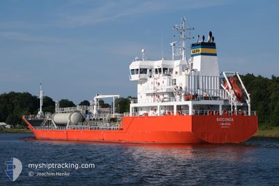
GIOCONDA
Tanker
Current Trip
| Time Travelled | 4 days |
|---|---|
| Remaining Time | 6 h, 56 mins |
| Distance Travelled | 780.30 nm |
| Remaining Distance | 48.31 nm |
| AVG Speed | 10 Knop |
| MAX Speed | 14.1 Knop |
| AVG Wind | 9.3 knots |
| MAX Wind | 26 knots |
| MIN Temp | -1.5°C / 29.3°F |
| MAX Temp | 5.3°C / 41.54°F |
| Djupgående | 6.9 m |
| Position mottagen | Nu |
Current Position
| Longitud | --- |
|---|---|
| Latitude | --- |
| Status | Under way using engine |
| Fart | 6.7 Knop |
| Kurs | 226.9° |
| Område | Baltic Sea |
| Station | T-AIS |
| Position mottagen | Nu |
Info
Information
The current position of GIOCONDA is in Baltic Sea with coordinates 53.91327° / 9.18101° as reported on 2025-03-17 22:01 by AIS to our vessel tracker app. The vessel's current speed is 6.7 Knop and is heading at the port of KIEL. The estimated time of arrival as calculated by MyShipTracking vessel tracking app is 2025-03-18 05:58 LT
The vessel GIOCONDA (IMO: 9819052, MMSI: 209415000) is a Tanker It's sailing under the flag of [CY] Cyprus.
In this page you can find informations about the vessels current position, last detected port calls, and current voyage information. If the vessels is not in coverage by AIS you will find the latest position.
The current position of GIOCONDA is detected by our AIS receivers and we are not responsible for the reliability of the data. The last position was recorded while the vessel was in Coverage by the Ais receivers of our vessel tracking app.
The current draught of GIOCONDA as reported by AIS is 6.9 meters
Weather
| Temperature | -0.5°C / 31.1°F |
|---|---|
| Wind Speed | 2 knots |
| Direction | 172° S |
| Pressure | 1033.3 hPa |
| Humidity | 44.8 % |
| Cloud Coverage | --- |
Featured Company
Last Port Calls
| Port | Arrival | Departure | Time In Port |
|---|---|---|---|
| 2025-03-12 23:35 | 2025-03-13 21:43 | 22 h | |
| 2025-03-08 04:57 | 2025-03-09 20:55 | 1 d | |
| 2025-03-05 14:56 | 2025-03-06 22:11 | 1 d | |
| 2025-03-02 10:44 | 2025-03-03 05:12 | 18 h | |
| 2025-02-27 06:15 | 2025-02-28 00:23 | 18 h | |
| 2025-02-22 15:09 | 2025-02-24 12:07 | 1 d | |
| 2025-02-19 06:05 | 2025-02-19 20:25 | 14 h | |
| 2025-02-16 21:10 | 2025-02-18 22:43 | 2 d | |
| 2025-02-14 15:33 | 2025-02-15 15:52 | 1 d | |
| 2025-02-14 00:07 | 2025-02-14 15:12 | 15 h |
Last Trips
| Origin | Departure | Destination | Arrival | Distance | |
|---|---|---|---|---|---|
| 2025-03-09 20:55 | 2025-03-12 23:35 | 955.86 nm | |||
| 2025-03-06 22:11 | 2025-03-08 04:57 | 160.99 nm | |||
| 2025-03-03 05:12 | 2025-03-05 14:56 | 408.64 nm | |||
| 2025-02-28 00:23 | 2025-03-02 10:44 | 203.73 nm | |||
| 2025-02-24 12:07 | 2025-02-27 06:15 | 493.64 nm | |||
| 2025-02-19 20:25 | 2025-02-22 15:09 | 376.02 nm | |||
| 2025-02-18 22:43 | 2025-02-19 06:05 | 37.60 nm | |||
| 2025-02-15 15:52 | 2025-02-16 21:10 | 332.13 nm | |||
| 2025-02-14 15:12 | 2025-02-14 15:33 | 1.23 nm | |||
| 2025-02-13 23:23 | 2025-02-14 00:07 | 3.05 nm |
Events
| Tid | Event | Detaljer | Position / Dest | Information |
|---|---|---|---|---|
| 2025-03-17 18:26 | STARTAR förflyttning | 6.81 nm, North East of FISCHERHUTTE |
54.19884 / 9.55091
DEKEL
|
Fart: 3.4 kn Kurs: 233° |
| 2025-03-17 17:57 | STOPPAR förflyttning | 6.93 nm, North East of FISCHERHUTTE |
54.20017 / 9.55363
DEKEL
|
Fart: 0.3 kn Kurs: 239° |
| 2025-03-17 17:06 | Status ändrad | Under way using engine Default |
54.25785 / 9.62064
DEKEL
|
Fart: 1.3 kn Kurs: 198° |
| 2025-03-17 17:02 | Status ändrad | Default Under way using engine |
54.26127 / 9.62256
DEKEL
|
Fart: 1.7 kn Kurs: 199° |
| 2025-03-17 13:40 | STARTAR förflyttning | 1.42 nm, South West of STICKENHΟRN SPORT |
54.36667 / 10.13831
DEKEL
|
Fart: 4.2 kn Kurs: 283° |
| 2025-03-17 13:10 | STOPPAR förflyttning | 1.37 nm, South West of STICKENHΟRN SPORT |
54.36611 / 10.14144
DEKEL
|
Fart: 0.3 kn Kurs: 284° |
| 2025-03-17 11:17 | Byter havsområde | German part of the Baltic Sea Danish part of the Baltic Sea |
54.56448 / 10.54995
Baltic Sea
DEKEL
|
Fart: 13 kn Kurs: 246.4° |
| 2025-03-17 10:35 | Byter havsområde | Danish part of the Baltic Sea German part of the Baltic Sea |
54.58739 / 10.80763
Baltic Sea
DEKEL
|
Fart: 13 kn Kurs: 264.4° |
| 2025-03-17 09:05 | Byter havsområde | German part of the Baltic Sea Danish part of the Baltic Sea |
54.54395 / 11.36213
Baltic Sea
DEKEL
|
Fart: 13.5 kn Kurs: 296.5° |
| 2025-03-17 04:01 | Byter havsområde | Danish part of the Baltic Sea German part of the Baltic Sea |
54.84448 / 12.93572
Baltic Sea
DEKEL
|
Fart: 13.4 kn Kurs: 252.2° |