
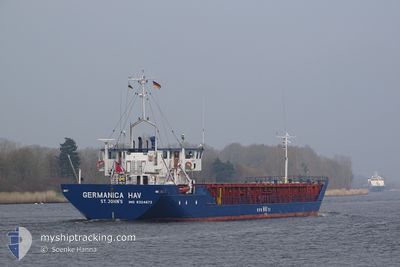
GERMANICA HAV
General Cargo
Current Trip
| Time Travelled | 18 h, 26 mins |
|---|---|
| Remaining Time | 9 h, 59 mins |
| Distance Travelled | 160.85 nm |
| Remaining Distance | 90.68 nm |
| AVG Speed | 8.3 Knop |
| MAX Speed | 10 Knop |
| AVG Wind | 12.9 knots |
| MAX Wind | 19 knots |
| MIN Temp | 7.8°C / 46.04°F |
| MAX Temp | 12.5°C / 54.5°F |
| Djupgående | 2.9 m |
| Position mottagen | 2 m sen |
Current Position
| Longitud | 13.53322° |
|---|---|
| Latitude | 54.69792° |
| Status | Under way using engine |
| Fart | 9.2 Knop |
| Kurs | 139.5° |
| Område | Baltic Sea |
| Station | T-AIS |
| Position mottagen | 2 m sen |
Info
Information
The current position of GERMANICA HAV is in Baltic Sea with coordinates 54.69792° / 13.53322° as reported on 2024-04-28 13:31 by AIS to our vessel tracker app. The vessel's current speed is 9.2 Knop and is heading at the port of SZCZECIN. The estimated time of arrival as calculated by MyShipTracking vessel tracking app is 2024-04-28 23:32 LT
The vessel GERMANICA HAV (IMO: 8324672, MMSI: 304953000) is a General Cargo that was built in 1984 ( 40 År gammal ). It's sailing under the flag of [AG] Antigua Barbuda.
In this page you can find informations about the vessels current position, last detected port calls, and current voyage information. If the vessels is not in coverage by AIS you will find the latest position.
The current position of GERMANICA HAV is detected by our AIS receivers and we are not responsible for the reliability of the data. The last position was recorded while the vessel was in Coverage by the Ais receivers of our vessel tracking app.
The current draught of GERMANICA HAV as reported by AIS is 2.9 meters
Weather
| Temperature | 10.7°C / 51.26°F |
|---|---|
| Wind Speed | 15 knots |
| Direction | 135° SE |
| Pressure | 1013.3 hPa |
| Humidity | 80 % |
| Cloud Coverage | 100 % |
Featured Company
Last Port Calls
| Port | Arrival | Departure | Time In Port |
|---|---|---|---|
| 2024-04-27 11:49 | 2024-04-27 19:07 | 7 h | |
| 2024-04-26 05:09 | 2024-04-26 15:31 | 10 h | |
| 2024-04-25 17:51 | 2024-04-25 18:39 | 47 m | |
| 2024-04-23 17:27 | 2024-04-25 12:59 | 1 d | |
| 2024-04-18 21:15 | 2024-04-22 16:28 | 3 d | |
| 2024-04-13 13:08 | 2024-04-18 09:34 | 4 d | |
| 2024-04-10 08:29 | 2024-04-12 12:06 | 2 d | |
| 2024-04-07 15:45 | 2024-04-08 04:35 | 12 h | |
| 2024-04-06 07:25 | 2024-04-06 22:40 | 15 h | |
| 2024-03-29 08:50 | 2024-04-02 11:09 | 4 d |
Most Visited Ports (Last year)
| Port | Arrivals | |
|---|---|---|
| 10 | ||
| 9 | ||
| 8 | ||
| 7 | ||
| 7 | ||
| 6 |
Last Trips
| Origin | Departure | Destination | Arrival | Distance | |
|---|---|---|---|---|---|
| 2024-04-26 17:31 | 2024-04-27 13:49 | 165.55 nm | |||
| 2024-04-25 20:39 | 2024-04-26 07:09 | 86.71 nm | |||
| 2024-04-25 14:59 | 2024-04-25 19:51 | 41.85 nm | |||
| 2024-04-22 18:28 | 2024-04-23 19:27 | 208.23 nm | |||
| 2024-04-18 11:34 | 2024-04-18 23:15 | 108.57 nm | |||
| 2024-04-12 14:06 | 2024-04-13 15:08 | 207.08 nm | |||
| 2024-04-08 07:35 | 2024-04-10 10:29 | 231.45 nm | |||
| 2024-04-07 01:40 | 2024-04-07 18:45 | 91.68 nm | |||
| 2024-04-02 13:09 | 2024-04-06 10:25 | 509.37 nm | |||
| 2024-03-27 08:48 | 2024-03-29 09:50 | 408.32 nm |
Events
| Tid | Event | Detaljer | Position / Dest | Information |
|---|---|---|---|---|
| 2024-04-28 13:31 | Status ändrad | Under way using engine Default |
54.69792 / 13.53322
PLSZZ
|
Fart: 9.2 kn Kurs: 139° |
| 2024-04-28 13:24 | Status ändrad | Default Under way using engine |
54.71021 / 13.51489
PLSZZ
|
Fart: 8.6 kn Kurs: 135.9° |
| 2024-04-28 10:28 | Byter havsområde | German part of the Baltic Sea Danish part of the Baltic Sea |
54.78250 / 12.80127
Baltic Sea
PLSZZ
|
Fart: 6.7 kn Kurs: 105.3° |
| 2024-04-28 07:55 | Byter havsområde | Danish part of the Baltic Sea Danish part of the Kattegat |
54.84171 / 12.17280
Baltic Sea
PLSZZ
|
Fart: 8.6 kn Kurs: 144.8° |
| 2024-04-27 19:07 | AVGÅTT HAMN |
|
55.70255 / 9.56890
PLSZZ
|
Fart: 6.9 kn Kurs: 111° |
| 2024-04-27 19:01 | STARTAR förflyttning |
55.70502 / 9.55383
[DK] VEJLE
|
Fart: 3.1 kn Kurs: 103° |
|
| 2024-04-27 18:28 | Status ändrad | Under way using engine Moored |
55.70587 / 9.55076
[DK] VEJLE
|
Fart: Kurs: 286° |
| 2024-04-27 18:01 | Djupgående ändrat | 2.9 4.4 |
55.70590 / 9.55070
[DK] VEJLE
|
Fart: Kurs: 286° |
| 2024-04-27 18:01 | Destination ändrad | PLSZZ VEJLE |
55.70590 / 9.55070
[DK] VEJLE
|
Fart: Kurs: 286° |
| 2024-04-27 18:01 | ETA ändrat | 2024/04/29 05:00 2024/04/27 12:00 |
55.70590 / 9.55070
[DK] VEJLE
|
Fart: Kurs: 286° |