
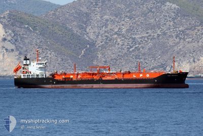
GAZ REDSEA
Lpg Tanker
Current Trip
| Time Travelled | 3 days |
|---|---|
| Remaining Time | --- |
| Distance Travelled | 788.92 nm |
| Remaining Distance | --- |
| AVG Speed | 10.9 Knop |
| MAX Speed | 13 Knop |
| AVG Wind | 11.4 knots |
| MAX Wind | 25.2 knots |
| MIN Temp | 9.5°C / 49.1°F |
| MAX Temp | 19.4°C / 66.92°F |
| Djupgående | 6.2 m |
| Position mottagen | 1 m sen |
Current Position
| Longitud | --- |
|---|---|
| Latitude | --- |
| Status | Under way using engine |
| Fart | 9.5 Knop |
| Kurs | 33.2° |
| Område | Sea of Marmara |
| Station | T-AIS |
| Position mottagen | 1 m sen |
Info
Information
The current position of GAZ REDSEA is in Sea of Marmara with coordinates 41.11687° / 29.07521° as reported on 2024-12-11 19:06 by AIS to our vessel tracker app. The vessel's current speed is 9.5 Knop and is heading at the port of GALATI. The estimated time of arrival as calculated by MyShipTracking vessel tracking app is 2024-12-12 21:00 LT
The vessel GAZ REDSEA (IMO: 9264192, MMSI: 353130000) is a Lpg Tanker that was built in 2002 ( 22 År gammal ). It's sailing under the flag of [PA] Panama.
In this page you can find informations about the vessels current position, last detected port calls, and current voyage information. If the vessels is not in coverage by AIS you will find the latest position.
The current position of GAZ REDSEA is detected by our AIS receivers and we are not responsible for the reliability of the data. The last position was recorded while the vessel was in Coverage by the Ais receivers of our vessel tracking app.
The current draught of GAZ REDSEA as reported by AIS is 6.2 meters
Weather
| Temperature | 10.4°C / 50.72°F |
|---|---|
| Wind Speed | 3 knots |
| Direction | 354° N |
| Pressure | 1022.6 hPa |
| Humidity | 72.7 % |
| Cloud Coverage | 92 % |
Featured Company
Last Port Calls
| Port | Arrival | Departure | Time In Port |
|---|---|---|---|
| 2024-12-07 09:08 | 2024-12-08 12:33 | 1 d | |
| 2024-11-27 13:59 | 2024-12-02 09:41 | 4 d | |
| 2024-11-19 14:08 | 2024-11-20 15:00 | 1 d | |
| 2024-11-15 18:36 | 2024-11-16 16:28 | 21 h | |
| 2024-11-14 06:34 | 2024-11-15 06:15 | 23 h | |
| 2024-11-11 06:18 | 2024-11-11 19:12 | 12 h | |
| 2024-11-09 21:42 | 2024-11-10 17:22 | 19 h | |
| 2024-11-09 05:58 | |||
| 2024-11-04 08:42 | 2024-11-06 02:18 | 1 d | |
| 2024-10-29 12:39 | 2024-11-01 11:27 | 2 d |
Last Trips
| Origin | Departure | Destination | Arrival | Distance | |
|---|---|---|---|---|---|
| 2024-12-02 09:41 | 2024-12-07 09:08 | 1107.44 nm | |||
| 2024-11-16 16:28 | 2024-11-19 14:08 | 300.83 nm | |||
| 2024-11-15 06:15 | 2024-11-15 18:36 | 122.33 nm | |||
| 2024-11-11 19:12 | 2024-11-14 06:34 | 504.36 nm | |||
| 2024-11-10 17:22 | 2024-11-11 06:18 | 4.41 nm | |||
| 2024-11-06 02:18 | 2024-11-09 05:58 | 908.30 nm | |||
| 2024-11-01 11:27 | 2024-11-04 08:42 | 421.41 nm | |||
| 2024-10-21 13:29 | 2024-10-29 12:39 | 1142.41 nm | |||
| 2024-10-10 11:25 | 2024-10-20 13:08 | 1407.62 nm | |||
| 2024-10-03 17:51 | 2024-10-09 07:49 | 1019.29 nm |
Events
| Tid | Event | Detaljer | Position / Dest | Information |
|---|---|---|---|---|
| 2024-12-11 16:07 | STARTAR förflyttning | 11.27 nm, South of YESILKOY |
40.77502 / 28.89532
RO GAL
|
Fart: 3.3 kn Kurs: 335° |
| 2024-12-11 10:48 | STOPPAR förflyttning | 9.61 nm, South of BAKIRKOY |
40.81945 / 28.93800
RO GAL
|
Fart: 0.3 kn Kurs: 38° |
| 2024-12-11 02:58 | Status ändrad | Under way using engine Default |
40.55271 / 27.13156
RO GAL
|
Fart: 11.6 kn Kurs: 68° |
| 2024-12-11 02:55 | I täckningsområde |
40.55271 / 27.13156
Sea of Marmara
RO GAL
|
Fart: 11.7 kn Kurs: 66° |
|
| 2024-12-11 00:31 | Status ändrad | Default Under way using engine |
40.33304 / 26.62890
RO GAL
|
Fart: 11.4 kn Kurs: 40.5° |
| 2024-12-11 00:21 | UTANFÖR täckningsområde |
40.30816 / 26.60158
Sea of Marmara
RO GAL
|
Fart: 11.4 kn Kurs: 40.5° |
|
| 2024-12-10 22:01 | Byter havsområde | Turkish part of the Sea of Marmara Turkish part of the Aegean Sea |
40.02051 / 26.22547
Sea of Marmara
RO GAL
|
Fart: 10.5 kn Kurs: 73.5° |
| 2024-12-10 22:00 | Status ändrad | Under way using engine Default |
40.01997 / 26.22304
RO GAL
|
Fart: 8.9 kn Kurs: 84° |
| 2024-12-10 21:46 | Status ändrad | Default Under way using engine |
40.01742 / 26.17827
RO GAL
|
Fart: 6.6 kn Kurs: 79.8° |
| 2024-12-10 21:42 | Status ändrad | Under way using engine Default |
40.01627 / 26.17022
RO GAL
|
Fart: 9 kn Kurs: 75° |