
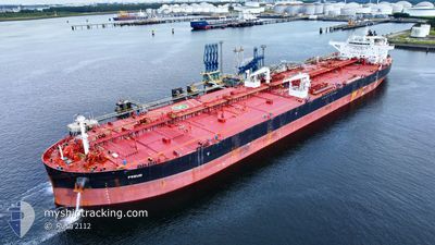
FREUD
Tanker
Current Trip
| Time Travelled | 30 days |
|---|---|
| Remaining Time | --- |
| Distance Travelled | 2843.44 nm |
| Remaining Distance | --- |
| AVG Speed | 10.5 Knop |
| MAX Speed | 10.5 Knop |
| AVG Wind | 7.9 knots |
| MAX Wind | 24 knots |
| MIN Temp | -2.1°C / 28.22°F |
| MAX Temp | 16.8°C / 62.24°F |
| Djupgående | 15.6 m |
| Position mottagen | 2 m sen |
Current Position
| Longitud | --- |
|---|---|
| Latitude | --- |
| Status | Under way using engine |
| Fart | 0.9 Knop |
| Kurs | 129° |
| Område | Black Sea |
| Station | T-AIS |
| Position mottagen | 2 m sen |
Info
Information
The current position of FREUD is in Black Sea with coordinates 41.42001° / 29.31810° as reported on 2025-02-16 13:51 by AIS to our vessel tracker app. The vessel's current speed is 0.9 Knop
The vessel FREUD (IMO: 9804461, MMSI: 538007563) is a Tanker It's sailing under the flag of [MH] Marshall Is.
In this page you can find informations about the vessels current position, last detected port calls, and current voyage information. If the vessels is not in coverage by AIS you will find the latest position.
The current position of FREUD is detected by our AIS receivers and we are not responsible for the reliability of the data. The last position was recorded while the vessel was in Coverage by the Ais receivers of our vessel tracking app.
The current draught of FREUD as reported by AIS is 15.6 meters
Weather
| Temperature | 7.5°C / 45.5°F |
|---|---|
| Wind Speed | 15 knots |
| Direction | 76° ENE |
| Pressure | 1016.6 hPa |
| Humidity | 92.1 % |
| Cloud Coverage | 100 % |
Featured Company
Most Visited Ports (Last year)
| Port | Arrivals | |
|---|---|---|
| 2 | ||
| 2 | ||
| 1 | ||
| 1 | ||
| 1 |
Last Trips
| Origin | Departure | Destination | Arrival | Distance | |
|---|---|---|---|---|---|
| 2024-11-13 14:07 | 2025-01-16 16:40 | 12924.27 nm |
Events
| Tid | Event | Detaljer | Position / Dest | Information |
|---|---|---|---|---|
| 2025-02-16 11:01 | Status ändrad | Under way using engine Default |
41.46232 / 29.31919
BOSPHORUS
|
Fart: 0.9 kn Kurs: 117° |
| 2025-02-16 10:55 | Status ändrad | Default Under way using engine |
41.46379 / 29.31878
BOSPHORUS
|
Fart: 0.9 kn Kurs: 118° |
| 2025-02-16 10:49 | Status ändrad | Under way using engine Default |
41.46531 / 29.31824
BOSPHORUS
|
Fart: 0.9 kn Kurs: 117° |
| 2025-02-16 10:42 | Status ändrad | Default Under way using engine |
41.46685 / 29.31768
BOSPHORUS
|
Fart: 0.9 kn Kurs: 118° |
| 2025-02-16 10:20 | Status ändrad | Under way using engine Default |
41.47227 / 29.31561
BOSPHORUS
|
Fart: 0.9 kn Kurs: 125° |
| 2025-02-16 10:10 | Status ändrad | Default Under way using engine |
41.47489 / 29.31469
BOSPHORUS
|
Fart: 1 kn Kurs: 125° |
| 2025-02-16 09:35 | Status ändrad | Under way using engine Default |
41.48340 / 29.31016
BOSPHORUS
|
Fart: 1 kn Kurs: 110° |
| 2025-02-16 09:26 | Status ändrad | Default Under way using engine |
41.48573 / 29.30858
BOSPHORUS
|
Fart: 1.1 kn Kurs: 111° |
| 2025-02-16 09:22 | Status ändrad | Under way using engine Default |
41.48685 / 29.30786
BOSPHORUS
|
Fart: 1.1 kn Kurs: 111° |
| 2025-02-16 09:10 | Status ändrad | Default Under way using engine |
41.49009 / 29.30574
BOSPHORUS
|
Fart: 1.1 kn Kurs: 111° |