
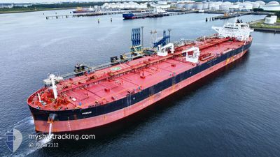
FREUD
Tanker
Current Trip
| Time Travelled | --- |
|---|---|
| Remaining Time | --- |
| Distance Travelled | 14181.14 nm |
| Remaining Distance | 139.34 nm |
| AVG Speed | 11.6 Noeuds |
| MAX Speed | 16.2 Noeuds |
| AVG Wind | 11.9 knots |
| MAX Wind | 40 knots |
| MIN Temp | 8.7°C / 47.66°F |
| MAX Temp | 29.3°C / 84.74°F |
| Tirant d eau | 9.3 m |
| Position reçue | 5 d depuis |
Current Position
| Longitude | --- |
|---|---|
| Latitude | --- |
| Etat | Under way using engine |
| Vitesse | 8.9 Noeuds |
| Parcours | 61.7° |
| Zone | Black Sea |
| Station | T-AIS |
| Position reçue | 5 d depuis |
Info
Information
The current position of FREUD is in Black Sea with coordinates 41.38419° / 29.39264° as reported on 2025-12-31 13:14 by AIS to our vessel tracker app. The vessel's current speed is 8.9 Noeuds and is heading at the port of NOVOROSSIYSK. The estimated time of arrival as calculated by MyShipTracking vessel tracking app is 2026-01-09 00:01 LT
The vessel FREUD (IMO: 9804461, MMSI: 538007563) is a Tanker It's sailing under the flag of [MH] Marshall Is.
In this page you can find informations about the vessels current position, last detected port calls, and current voyage information. If the vessels is not in coverage by AIS you will find the latest position.
The current position of FREUD is detected by our AIS receivers and we are not responsible for the reliability of the data. The last position was recorded while the vessel was in Coverage by the Ais receivers of our vessel tracking app.
The current draught of FREUD as reported by AIS is 9.3 meters
Weather
| Temperature | 11°C / 51.8°F |
|---|---|
| Wind Speed | 6 knots |
| Direction | 137° SE |
| Pressure | 1021.6 hPa |
| Humidity | 74.1 % |
| Cloud Coverage | 82 % |
Featured Company
Last Port Calls
| Port | Arrival | Departure | Time In Port |
|---|---|---|---|
| 2025-12-19 07:39 | 2025-12-19 17:02 | 9 h |
Most Visited Ports (Last year)
| Port | Arrivals | |
|---|---|---|
| 3 | ||
| 3 | ||
| 1 | ||
| 1 | ||
| 1 | ||
| 1 |
Last Trips
| Origin | Departure | Destination | Arrival | Distance | |
|---|---|---|---|---|---|
| 2025-09-27 22:42 | 2025-12-19 07:39 | 13247.45 nm |
Events
| Heure | Evenement | Détails | Position/ Destination | Info |
|---|---|---|---|---|
| 2025-12-31 13:19 | Etat Changé | Default Under way using engine |
41.39002 / 29.40807
RUNVS
|
Vitesse: 8.9 kn Parcours: 61.7° |
| 2025-12-31 13:14 | Etat Changé | Under way using engine Default |
41.38419 / 29.39264
RUNVS
|
Vitesse: 9 kn Parcours: 61° |
| 2025-12-31 13:14 | Hors de la zone couverte |
41.38419 / 29.39264
Black Sea
RUNVS
|
Vitesse: 8.9 kn Parcours: 61.7° |
|
| 2025-12-31 13:10 | Etat Changé | Default Under way using engine |
41.37876 / 29.37963
RUNVS
|
Vitesse: 9.1 kn Parcours: 60.2° |
| 2025-12-31 12:00 | Tirant d'eau modifié | 9.3 9.5 |
41.26525 / 29.19186
RUNVS
|
Vitesse: 10.3 kn Parcours: 48.9° |
| 2025-12-31 11:43 | Changement de zone | Turkish part of the Black Sea Turkish part of the Sea of Marmara |
41.23415 / 29.14740
Black Sea
RUNVS
|
Vitesse: 8.2 kn Parcours: 40.2° |
| 2025-12-31 06:01 | Démarrage | 6.64 nm, South West of KARTAL |
40.79102 / 29.12003
RUNVS
|
Vitesse: 3.1 kn Parcours: 286° |
| 2025-12-30 23:52 | Arret | 7.56 nm, South of MALTEPE |
40.79428 / 29.08354
RUNVS
|
Vitesse: 0.3 kn Parcours: 149° |
| 2025-12-30 21:45 | Démarrage | 11.58 nm, West of YALOVA |
40.71186 / 29.03006
RUNVS
|
Vitesse: 3.2 kn Parcours: 310° |
| 2025-12-30 17:30 | Arret | 8.13 nm, North West of YALOVA |
40.73089 / 29.12156
RUNVS
|
Vitesse: 0.3 kn Parcours: 241° |