
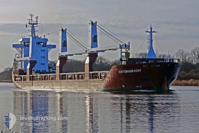
FORTUNAGRACHT
General Cargo
Current Trip
| Time Travelled | 4 days |
|---|---|
| Remaining Time | --- |
| Distance Travelled | 1004.71 nm |
| Remaining Distance | --- |
| AVG Speed | 11.9 Knop |
| MAX Speed | 14.7 Knop |
| AVG Wind | 7.3 knots |
| MAX Wind | 12.8 knots |
| MIN Temp | 25.5°C / 77.9°F |
| MAX Temp | 33.4°C / 92.12°F |
| Djupgående | 8.1 m |
| Position mottagen | 2024-10-10 07:43 |
Current Position
| Longitud | --- |
|---|---|
| Latitude | --- |
| Status | Under way using engine |
| Fart | 12.4 Knop |
| Kurs | 129.7° |
| Område | Gulf of Mexico |
| Station | T-AIS |
| Position mottagen | 2024-10-10 07:43 |
Info
Information
The current position of FORTUNAGRACHT is in Gulf of Mexico with coordinates 29.17844° / -94.48705° as reported on 2024-10-10 07:43 by AIS to our vessel tracker app. The vessel's current speed is 12.4 Knop and is heading at the port of POINTE NOIRE.
The vessel FORTUNAGRACHT (IMO: 9507609, MMSI: 246621000) is a General Cargo that was built in 2012 ( 12 År gammal ). It's sailing under the flag of [NL] Netherlands.
In this page you can find informations about the vessels current position, last detected port calls, and current voyage information. If the vessels is not in coverage by AIS you will find the latest position.
The current position of FORTUNAGRACHT is detected by our AIS receivers and we are not responsible for the reliability of the data. The last position was recorded while the vessel was in Coverage by the Ais receivers of our vessel tracking app.
The current draught of FORTUNAGRACHT as reported by AIS is 8.1 meters
Weather
| Temperature | 26.3°C / 79.34°F |
|---|---|
| Wind Speed | 10 knots |
| Direction | 203° SSW |
| Pressure | 1010.5 hPa |
| Humidity | 79.1 % |
| Cloud Coverage | 100 % |
Featured Company
Last Port Calls
| Port | Arrival | Departure | Time In Port |
|---|---|---|---|
| 2024-11-27 13:06 | 2024-11-28 08:51 | 19 h | |
| 2024-11-22 15:19 | 2024-11-24 09:04 | 1 d | |
| 2024-11-18 21:43 | 2024-11-19 09:04 | 11 h | |
| 2024-11-15 14:40 | 2024-11-16 10:00 | 19 h | |
| 2024-11-11 16:53 | 2024-11-13 14:50 | 1 d | |
| 2024-11-08 09:23 | 2024-11-09 16:27 | 1 d | |
| 2024-11-04 08:11 | 2024-11-07 03:03 | 2 d | |
| 2024-10-02 18:14 | 2024-10-09 23:30 | 7 d | |
| 2024-10-01 12:23 |
Most Visited Ports (Last year)
| Port | Arrivals | |
|---|---|---|
| 4 | ||
| 2 | ||
| 2 | ||
| 2 | ||
| 2 | ||
| 1 |
Last Trips
| Origin | Departure | Destination | Arrival | Distance | |
|---|---|---|---|---|---|
| 2024-11-24 09:04 | 2024-11-27 13:06 | 297.16 nm | |||
| 2024-11-19 09:04 | 2024-11-22 15:19 | 222.52 nm | |||
| 2024-11-16 10:00 | 2024-11-18 21:43 | 99.87 nm | |||
| 2024-11-13 14:50 | 2024-11-15 14:40 | 328.70 nm | |||
| 2024-11-09 16:27 | 2024-11-11 16:53 | 608.41 nm | |||
| 2024-11-07 03:03 | 2024-11-08 09:23 | 299.29 nm | |||
| 2024-10-09 23:30 | 2024-11-04 08:11 | 6592.55 nm | |||
| 2024-10-01 12:23 | 2024-10-02 18:14 | 432.42 nm |
Events
| Tid | Event | Detaljer | Position / Dest | Information |
|---|---|---|---|---|
| 2024-11-29 14:14 | STARTAR förflyttning | 3.23 nm, South West of ESCRAVOS |
5.56677 / 5.16600
CGPNR
|
Fart: 6.6 kn Kurs: 216° |
| 2024-11-28 14:33 | STOPPAR förflyttning | 2.09 nm, South West of ESCRAVOS |
5.58200 / 5.17741
CGPNR
|
Fart: 0.1 kn Kurs: 210° |
| 2024-11-28 07:51 | AVGÅTT HAMN |
|
5.52364 / 5.70690
CGPNR
|
Fart: 7.3 kn Kurs: 317° |
| 2024-11-28 07:47 | STARTAR förflyttning |
5.51468 / 5.71387
[NG] WARRI
|
Fart: 7.3 kn Kurs: 317° |
|
| 2024-11-27 12:06 | STOPPAR förflyttning |
5.51417 / 5.72552
[NG] WARRI
|
Fart: 0.3 kn Kurs: 357° |
|
| 2024-11-27 12:06 | ANLÄNDER HAMN |
|
5.51417 / 5.72552
[NG] WARRI
|
Fart: 1.5 kn Kurs: 43° |
| 2024-11-27 06:00 | STARTAR förflyttning | 4.98 nm, East of ESCRAVOS |
5.60563 / 5.28381
CGPNR
|
Fart: 6.5 kn Kurs: 102° |
| 2024-11-26 13:56 | STOPPAR förflyttning | 4.86 nm, East of ESCRAVOS |
5.60577 / 5.28179
CGPNR
|
Fart: 0.2 kn Kurs: 281° |
| 2024-11-26 11:18 | STARTAR förflyttning | 10.63 nm, South West of ESCRAVOS |
5.47595 / 5.08176
CGPNR
|
Fart: 4.4 kn Kurs: 359° |
| 2024-11-25 11:35 | STOPPAR förflyttning | 10.7 nm, South West of ESCRAVOS |
5.46958 / 5.08727
CGPNR
|
Fart: 0.3 kn Kurs: 96° |