

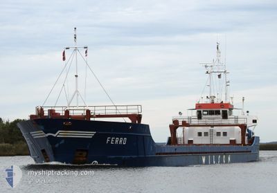
FERRO
General Cargo

Current Trip
| Time Travelled | 1 day |
|---|---|
| Remaining Time | 1 day |
| Distance Travelled | 114.07 nm |
| Remaining Distance | 281.81 nm |
| AVG Speed | 7.9 Knop |
| MAX Speed | 12.7 Knop |
| AVG Wind | 17.1 knots |
| MAX Wind | 21 knots |
| MIN Temp | 4.5°C / 40.1°F |
| MAX Temp | 7.2°C / 44.96°F |
| Djupgående | 3.3 m |
| Position mottagen | 12 h, 25 m sen |
Current Position
| Longitud | --- |
|---|---|
| Latitude | --- |
| Status | Under way using engine |
| Fart | 8.5 Knop |
| Kurs | 49° |
| Område | North Sea |
| Station | T-AIS |
| Position mottagen | 12 h, 25 m sen |
Information
The current position of FERRO is in North Sea with coordinates 51.98264° / 2.88017° as reported on 2025-03-16 05:56 by AIS to our vessel tracker app. The vessel's current speed is 8.5 Knop and is heading at the port of HAMBURG. The estimated time of arrival as calculated by MyShipTracking vessel tracking app is 2025-03-18 00:12 LT
The vessel FERRO (IMO: 9005730, MMSI: 314415000) is a General Cargo that was built in 1991 ( 34 År gammal ). It's sailing under the flag of [BB] Barbados.
In this page you can find informations about the vessels current position, last detected port calls, and current voyage information. If the vessels is not in coverage by AIS you will find the latest position.
The current position of FERRO is detected by our AIS receivers and we are not responsible for the reliability of the data. The last position was recorded while the vessel was in Coverage by the Ais receivers of our vessel tracking app.
The current draught of FERRO as reported by AIS is 3.3 meters
Weather
| Temperature | 6.1°C / 42.98°F |
|---|---|
| Wind Speed | 11 knots |
| Direction | 331° NNW |
| Pressure | 1023.3 hPa |
| Humidity | 84.5 % |
| Cloud Coverage | 74 % |


Featured Company
Last Port Calls
| Port | Arrival | Departure | Time In Port |
|---|---|---|---|
| 2025-03-14 05:15 | 2025-03-15 16:11 | 1 d | |
| 2025-03-08 12:56 | 2025-03-10 19:27 | 2 d | |
| 2025-03-01 19:48 | 2025-03-03 20:08 | 2 d | |
| 2025-03-01 19:33 | 2025-03-01 19:41 | 7 m | |
| 2025-02-24 05:19 | 2025-02-24 06:53 | 1 h | |
| 2025-02-23 20:43 | 2025-02-23 21:25 | 42 m | |
| 2025-02-20 15:09 | 2025-02-22 07:53 | 1 d | |
| 2025-02-07 22:07 | 2025-02-08 14:29 | 16 h | |
| 2025-02-05 21:05 | 2025-02-07 01:58 | 1 d | |
| 2025-01-29 21:12 | 2025-01-30 23:07 | 1 d |
Last Trips
| Origin | Departure | Destination | Arrival | Distance | |
|---|---|---|---|---|---|
| 2025-03-10 19:27 | 2025-03-14 05:15 | 743.52 nm | |||
| 2025-03-03 20:08 | 2025-03-08 12:56 | 559.47 nm | |||
| 2025-03-01 19:41 | 2025-03-01 19:48 | 0.89 nm | |||
| 2025-02-24 06:53 | 2025-03-01 19:33 | 801.52 nm | |||
| 2025-02-23 21:25 | 2025-02-24 05:19 | 50.79 nm | |||
| 2025-02-22 07:53 | 2025-02-23 20:43 | 355.62 nm | |||
| 2025-02-08 14:29 | 2025-02-20 15:09 | 980.42 nm | |||
| 2025-02-07 01:58 | 2025-02-07 22:07 | 180.57 nm | |||
| 2025-01-30 23:07 | 2025-02-05 21:05 | 511.60 nm | |||
| 2025-01-29 20:23 | 2025-01-29 21:12 | 5.41 nm |
Events
| Tid | Event | Detaljer | Position / Dest | Information |
|---|---|---|---|---|
| 2025-03-16 05:59 | Status ändrad | Default Under way using engine |
51.98714 / 2.88853
DEHAM
|
Fart: 8.5 kn Kurs: 49° |
| 2025-03-16 05:56 | UTANFÖR täckningsområde |
51.98264 / 2.88017
North Sea
DEHAM
|
Fart: 8.5 kn Kurs: 49° |
|
| 2025-03-16 04:20 | Byter havsområde | Dutch part of the North Sea Belgian part of the North Sea |
51.81359 / 2.64458
North Sea
DEHAM
|
Fart: 5.5 kn Kurs: 38.9° |
| 2025-03-16 02:24 | Status ändrad | Under way using engine Default |
51.59659 / 2.34310
DEHAM
|
Fart: 8.7 kn Kurs: 44° |
| 2025-03-16 02:16 | Status ändrad | Default Under way using engine |
51.58168 / 2.32109
DEHAM
|
Fart: 8.9 kn Kurs: 43.7° |
| 2025-03-16 02:05 | Status ändrad | Under way using engine Default |
51.56227 / 2.29164
DEHAM
|
Fart: 8.6 kn Kurs: 44° |
| 2025-03-16 02:01 | Status ändrad | Default Under way using engine |
51.55471 / 2.27994
DEHAM
|
Fart: 8.7 kn Kurs: 44.4° |
| 2025-03-16 01:56 | Upptäckt i hav | Belgian part of the North Sea |
51.54586 / 2.26619
North Sea
DEHAM
|
Fart: 8.7 kn Kurs: 44.4° |
| 2025-03-16 01:56 | Status ändrad | Under way using engine Default |
51.54586 / 2.26619
DEHAM
|
Fart: 8.8 kn Kurs: 43° |
| 2025-03-16 01:04 | Status ändrad | Default Under way using engine |
51.46325 / 2.13491
DEHAM
|
Fart: 7.8 kn Kurs: 46.2° |