

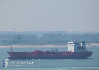
FERICEK
Oil/Chemical Tanker

Current Trip
| Time Travelled | 6 days |
|---|---|
| Remaining Time | --- |
| Distance Travelled | 848.59 nm |
| Remaining Distance | --- |
| AVG Speed | 10.7 Knop |
| MAX Speed | 14.9 Knop |
| AVG Wind | 13.6 knots |
| MAX Wind | 28.5 knots |
| MIN Temp | 2.8°C / 37.04°F |
| MAX Temp | 16.1°C / 60.98°F |
| Djupgående | 5 m |
| Position mottagen | 3 d sen |
Current Position
| Longitud | --- |
|---|---|
| Latitude | --- |
| Status | Under way using engine |
| Fart | 10.2 Knop |
| Kurs | 136.7° |
| Område | Mediterranean Sea - Eastern Basin |
| Station | T-AIS |
| Position mottagen | 3 d sen |
Information
The current position of FERICEK is in Mediterranean Sea - Eastern Basin with coordinates 35.60347° / 27.79787° as reported on 2025-03-20 20:40 by AIS to our vessel tracker app. The vessel's current speed is 10.2 Knop
The vessel FERICEK (IMO: 9125267, MMSI: 271046574) is a Oil/Chemical Tanker that was built in 1996 ( 29 År gammal ). It's sailing under the flag of [TR] Turkey.
In this page you can find informations about the vessels current position, last detected port calls, and current voyage information. If the vessels is not in coverage by AIS you will find the latest position.
The current position of FERICEK is detected by our AIS receivers and we are not responsible for the reliability of the data. The last position was recorded while the vessel was in Coverage by the Ais receivers of our vessel tracking app.
The current draught of FERICEK as reported by AIS is 5 meters
Weather
| Temperature | 17°C / 62.6°F |
|---|---|
| Wind Speed | 14 knots |
| Direction | 44° NE |
| Pressure | 1027.2 hPa |
| Humidity | 66.2 % |
| Cloud Coverage | --- |


Featured Company
Last Port Calls
| Port | Arrival | Departure | Time In Port |
|---|---|---|---|
| 2025-03-16 13:46 | 2025-03-17 19:12 | 1 d | |
| 2025-03-14 07:46 | 2025-03-15 06:48 | 23 h | |
| 2025-03-07 21:32 | 2025-03-11 00:33 | 3 d | |
| 2025-02-28 13:41 | 2025-03-01 14:53 | 1 d | |
| 2025-02-24 16:25 | 2025-02-26 06:53 | 1 d | |
| 2025-02-21 08:05 | 2025-02-22 17:29 | 1 d | |
| 2025-02-12 07:56 | 2025-02-12 13:24 | 5 h | |
| 2025-02-09 10:07 | 2025-02-10 20:47 | 1 d | |
| 2025-01-27 17:58 | 2025-01-28 18:07 | 1 d | |
| 2025-01-19 23:28 | 2025-01-22 22:33 | 2 d |
Last Trips
| Origin | Departure | Destination | Arrival | Distance | |
|---|---|---|---|---|---|
| 2025-03-15 06:48 | 2025-03-16 13:46 | 308.97 nm | |||
| 2025-03-11 00:33 | 2025-03-14 07:46 | 617.88 nm | |||
| 2025-03-01 14:53 | 2025-03-07 21:32 | 430.59 nm | |||
| 2025-02-26 06:53 | 2025-02-28 13:41 | 405.57 nm | |||
| 2025-02-22 17:29 | 2025-02-24 16:25 | 455.08 nm | |||
| 2025-02-12 13:24 | 2025-02-21 08:05 | 2077.22 nm | |||
| 2025-02-10 20:47 | 2025-02-12 07:56 | 343.00 nm | |||
| 2025-01-28 18:07 | 2025-02-09 10:07 | 889.62 nm | |||
| 2025-01-22 22:33 | 2025-01-27 17:58 | 1148.83 nm | |||
| 2025-01-11 19:43 | 2025-01-19 23:28 | 1059.39 nm |
Events
| Tid | Event | Detaljer | Position / Dest | Information |
|---|---|---|---|---|
| 2025-03-22 07:18 | STOPPAR förflyttning | 17.49 nm, North of PORT SAID |
31.54386 / 32.30249
EGPSD
|
Fart: Kurs: 13° |
| 2025-03-20 20:46 | Status ändrad | Default Under way using engine |
35.59264 / 27.81111
EGPSD
|
Fart: 10.2 kn Kurs: 136.7° |
| 2025-03-20 20:40 | UTANFÖR täckningsområde |
35.60347 / 27.79787
Mediterranean Sea - Eastern Basin
EGPSD
|
Fart: 10.2 kn Kurs: 136.7° |
|
| 2025-03-20 19:14 | Byter havsområde | Greek part of the Mediterranean Sea - Eastern Basin Greek part of the Aegean Sea |
35.78922 / 27.59087
Mediterranean Sea - Eastern Basin
EGPSD
|
Fart: 10.9 kn Kurs: 140.7° |
| 2025-03-20 15:36 | Status ändrad | Under way using engine Default |
36.28486 / 27.09996
EGPSD
|
Fart: 10.5 kn Kurs: 136° |
| 2025-03-20 15:17 | I täckningsområde |
36.28410 / 27.10083
Aegean Sea
EGPSD
|
Fart: 10.7 kn Kurs: 139.1° |
|
| 2025-03-20 00:59 | Status ändrad | Default Under way using engine |
38.45345 / 25.71839
EGPSD
|
Fart: 11.3 kn Kurs: 174.2° |
| 2025-03-20 00:47 | UTANFÖR täckningsområde |
38.49098 / 25.71435
Aegean Sea
EGPSD
|
Fart: 11.3 kn Kurs: 174.2° |
|
| 2025-03-19 22:07 | Status ändrad | Under way using engine Default |
38.99207 / 25.68614
EGPSD
|
Fart: 11.1 kn Kurs: 174° |
| 2025-03-19 21:59 | Status ändrad | Default Under way using engine |
39.01494 / 25.68310
EGPSD
|
Fart: 11.2 kn Kurs: 174.5° |