

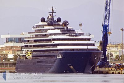
EVRIMA
Passenger

Current Trip
MQ FDF
| Time Travelled | 1 h, 54 mins |
|---|---|
| Remaining Time | --- |
| Distance Travelled | 4.10 nm |
| Remaining Distance | --- |
| AVG Speed | 7.1 Knop |
| MAX Speed | 10.8 Knop |
| AVG Wind | 13 knots |
| MAX Wind | 13 knots |
| MIN Temp | 25.2°C / 77.36°F |
| MAX Temp | 25.9°C / 78.62°F |
| Djupgående | 6 m |
| Position mottagen | 3 m sen |
Current Position
| Longitud | --- |
|---|---|
| Latitude | --- |
| Status | At anchor |
| Fart | |
| Kurs | 105° |
| Område | Caribbean Sea |
| Station | T-AIS |
| Position mottagen | 3 m sen |
Information
The current position of EVRIMA is in Caribbean Sea with coordinates 14.55445° / -61.07550° as reported on 2025-02-24 14:07 by AIS to our vessel tracker app. The vessel's current speed is 0 Knop
The vessel EVRIMA (IMO: 9823687, MMSI: 215001000) is a Passenger It's sailing under the flag of [MT] Malta.
In this page you can find informations about the vessels current position, last detected port calls, and current voyage information. If the vessels is not in coverage by AIS you will find the latest position.
The current position of EVRIMA is detected by our AIS receivers and we are not responsible for the reliability of the data. The last position was recorded while the vessel was in Coverage by the Ais receivers of our vessel tracking app.
The current draught of EVRIMA as reported by AIS is 6 meters
Weather
| Temperature | 26.1°C / 78.98°F |
|---|---|
| Wind Speed | 13 knots |
| Direction | 91° E |
| Pressure | 1016.3 hPa |
| Humidity | 74.8 % |
| Cloud Coverage | 67 % |


Featured Company
Last Port Calls
| Port | Arrival | Departure | Time In Port |
|---|---|---|---|
| 2025-02-24 10:22 | 2025-02-24 12:16 | 1 h | |
| 2025-02-22 12:14 | 2025-02-23 00:46 | 12 h | |
| 2025-02-21 09:22 | 2025-02-21 22:54 | 13 h | |
| 2025-02-19 11:20 | 2025-02-20 01:14 | 13 h | |
| 2025-02-16 09:45 | 2025-02-16 23:22 | 13 h | |
| 2025-02-14 11:15 | 2025-02-14 22:31 | 11 h | |
| 2025-02-13 11:23 | 2025-02-13 22:35 | 11 h | |
| 2025-02-09 09:41 | 2025-02-09 23:07 | 13 h | |
| 2025-02-06 11:15 | 2025-02-06 22:26 | 11 h | |
| 2025-02-04 10:49 | 2025-02-04 23:06 | 12 h |
Most Visited Ports (Last year)
| Port | Arrivals | |
|---|---|---|
| 12 | ||
| 9 | ||
| 8 | ||
| 7 | ||
| 6 | ||
| 6 |
Last Trips
| Origin | Departure | Destination | Arrival | Distance | |
|---|---|---|---|---|---|
| 2025-02-22 20:46 | 2025-02-24 06:22 | 196.23 nm | |||
| 2025-02-21 18:54 | 2025-02-22 08:14 | 148.42 nm | |||
| 2025-02-19 21:14 | 2025-02-21 05:22 | 183.57 nm | |||
| 2025-02-16 19:22 | 2025-02-19 07:20 | 364.63 nm | |||
| 2025-02-14 18:31 | 2025-02-16 05:45 | 201.36 nm | |||
| 2025-02-13 18:35 | 2025-02-14 07:15 | 159.69 nm | |||
| 2025-02-09 19:07 | 2025-02-13 07:23 | 601.89 nm | |||
| 2025-02-06 18:26 | 2025-02-09 05:41 | 310.64 nm | |||
| 2025-02-04 19:06 | 2025-02-06 07:15 | 219.97 nm | |||
| 2025-02-02 19:35 | 2025-02-04 06:49 | 294.98 nm |
Events
| Tid | Event | Detaljer | Position / Dest | Information |
|---|---|---|---|---|
| 2025-02-24 12:46 | Status ändrad | At anchor Under way using engine |
14.55397 / -61.07437
MQ FDF
|
Fart: 0.5 kn Kurs: 57° |
| 2025-02-24 12:46 | STOPPAR förflyttning | 2.47 nm, South West of FORT DE FRANCE |
14.55397 / -61.07432
MQ FDF
|
Fart: 0.3 kn Kurs: 53° |
| 2025-02-24 12:16 | AVGÅTT HAMN |
|
14.58950 / -61.06352
MQ FDF
|
Fart: 9.2 kn Kurs: 200° |
| 2025-02-24 12:13 | STARTAR förflyttning |
14.59673 / -61.06233
[MQ] FORT DE FRANCE
|
Fart: 6 kn Kurs: 191° |
|
| 2025-02-24 12:13 | ETA ändrat | 2025/02/24 12:15 2025/02/24 10:00 |
14.59708 / -61.06225
[MQ] FORT DE FRANCE
|
Fart: 5.8 kn Kurs: 193° |
| 2025-02-24 12:06 | Status ändrad | Under way using engine Moored |
14.60060 / -61.06082
[MQ] FORT DE FRANCE
|
Fart: Kurs: 225° |
| 2025-02-24 10:51 | Status ändrad | Moored Under way using engine |
14.60060 / -61.06082
[MQ] FORT DE FRANCE
|
Fart: 0.1 kn Kurs: 225° |
| 2025-02-24 10:28 | STOPPAR förflyttning |
14.59863 / -61.06282
[MQ] FORT DE FRANCE
|
Fart: 0.3 kn Kurs: 260° |
|
| 2025-02-24 10:22 | ANLÄNDER HAMN |
|
14.59150 / -61.06292
[MQ] FORT DE FRANCE
|
Fart: 5.7 kn Kurs: 19.4° |
| 2025-02-24 07:29 | Byter havsområde | Guadeloupe and Martinique part of the Caribbean Sea Saint Lucia part of the Caribbean Sea |
14.21267 / -61.29380
Caribbean Sea
MQ FDF
|
Fart: 10.7 kn Kurs: 5.1° |