
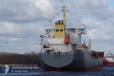
EKFJORD
Oil Products Tanker
Current Trip
| Time Travelled | 23 h, 1 mins |
|---|---|
| Remaining Time | 19 h, 57 mins |
| Distance Travelled | 160.59 nm |
| Remaining Distance | 232.52 nm |
| AVG Speed | 10.8 Knop |
| MAX Speed | 13.7 Knop |
| AVG Wind | 15.6 knots |
| MAX Wind | 20.4 knots |
| MIN Temp | 9.8°C / 49.64°F |
| MAX Temp | 10.8°C / 51.44°F |
| Djupgående | 6.8 m |
| Position mottagen | Nu |
Current Position
| Longitud | 1.10782° |
|---|---|
| Latitude | 53.81739° |
| Status | Under way using engine |
| Fart | 11.2 Knop |
| Kurs | 322° |
| Område | North Sea |
| Station | T-AIS |
| Position mottagen | Nu |
Info
Information
The current position of EKFJORD is in North Sea with coordinates 53.81739° / 1.10782° as reported on 2024-04-29 21:34 by AIS to our vessel tracker app. The vessel's current speed is 11.2 Knop and is heading at the port of GRANGEMOUTH. The estimated time of arrival as calculated by MyShipTracking vessel tracking app is 2024-04-30 17:32 LT
The vessel EKFJORD (IMO: 9356622, MMSI: 257555000) is a Oil Products Tanker that was built in 2009 ( 15 År gammal ). It's sailing under the flag of [NO] Norway.
In this page you can find informations about the vessels current position, last detected port calls, and current voyage information. If the vessels is not in coverage by AIS you will find the latest position.
The current position of EKFJORD is detected by our AIS receivers and we are not responsible for the reliability of the data. The last position was recorded while the vessel was in Coverage by the Ais receivers of our vessel tracking app.
The current draught of EKFJORD as reported by AIS is 6.8 meters
Weather
| Temperature | 9.9°C / 49.82°F |
|---|---|
| Wind Speed | 20 knots |
| Direction | 177° S |
| Pressure | 1014.5 hPa |
| Humidity | 80.8 % |
| Cloud Coverage | 95 % |
Featured Company
Last Port Calls
| Port | Arrival | Departure | Time In Port |
|---|---|---|---|
| 2024-04-27 08:59 | 2024-04-28 22:34 | 1 d | |
| 2024-04-24 22:20 | 2024-04-24 23:17 | 56 m | |
| 2024-04-21 01:44 | 2024-04-24 21:32 | 3 d | |
| 2024-04-20 21:45 | 2024-04-21 01:14 | 3 h | |
| 2024-04-15 08:54 | 2024-04-16 18:45 | 1 d | |
| 2024-04-12 21:01 | 2024-04-13 22:38 | 1 d | |
| 2024-04-08 08:52 | 2024-04-10 22:03 | 2 d | |
| 2024-04-02 19:54 | 2024-04-04 23:05 | 2 d | |
| 2024-03-22 04:54 | 2024-03-22 11:20 | 6 h | |
| 2024-03-20 21:55 | 2024-03-22 04:21 | 1 d |
Last Trips
| Origin | Departure | Destination | Arrival | Distance | |
|---|---|---|---|---|---|
| 2024-04-25 00:17 | 2024-04-27 10:59 | 736.55 nm | |||
| 2024-04-24 22:32 | 2024-04-24 23:20 | 1.91 nm | |||
| 2024-04-21 02:14 | 2024-04-21 02:44 | 1.59 nm | |||
| 2024-04-16 20:45 | 2024-04-20 22:45 | 728.71 nm | |||
| 2024-04-14 00:38 | 2024-04-15 10:54 | 370.15 nm | |||
| 2024-04-11 00:03 | 2024-04-12 23:01 | 338.34 nm | |||
| 2024-04-05 00:05 | 2024-04-08 10:52 | 415.89 nm | |||
| 2024-03-22 12:20 | 2024-04-02 20:54 | 446.68 nm | |||
| 2024-03-22 05:21 | 2024-03-22 05:54 | 2.85 nm | |||
| 2024-03-19 10:17 | 2024-03-20 22:55 | 407.01 nm |
Events
| Tid | Event | Detaljer | Position / Dest | Information |
|---|---|---|---|---|
| 2024-04-29 17:49 | Destination ändrad | GB GRG MAAS ANCH FOR ORDERS |
53.33780 / 2.02545
GB GRG
|
Fart: 12.9 kn Kurs: 311.2° |
| 2024-04-29 17:49 | ETA ändrat | 2024/04/30 17:00 2024/04/29 02:00 |
53.33780 / 2.02545
GB GRG
|
Fart: 12.9 kn Kurs: 311.2° |
| 2024-04-29 17:03 | Status ändrad | Under way using engine Default |
53.23135 / 2.23428
MAAS ANCH FOR ORDERS
|
Fart: 13.4 kn Kurs: 311° |
| 2024-04-29 17:01 | Status ändrad | Default Under way using engine |
53.22452 / 2.24765
MAAS ANCH FOR ORDERS
|
Fart: 13.4 kn Kurs: 311° |
| 2024-04-29 17:00 | Status ändrad | Under way using engine Default |
53.22367 / 2.24930
MAAS ANCH FOR ORDERS
|
Fart: 13.3 kn Kurs: 312° |
| 2024-04-29 17:00 | I täckningsområde |
53.22367 / 2.24930
North Sea
|
Fart: 13.4 kn Kurs: 311° |
|
| 2024-04-29 17:00 | Byter havsområde | United Kingdom part of the North Sea Dutch part of the North Sea |
53.22367 / 2.24930
North Sea
|
Fart: 13.4 kn Kurs: 311° |
| 2024-04-29 10:28 | Status ändrad | Default Under way using engine |
52.17905 / 3.51023
MAAS ANCH FOR ORDERS
|
Fart: 12.2 kn Kurs: 316.7° |
| 2024-04-29 10:27 | UTANFÖR täckningsområde |
52.17660 / 3.51413
North Sea
|
Fart: 12.2 kn Kurs: 316.7° |
|
| 2024-04-29 10:00 | STARTAR förflyttning | 18.92 nm, North West of MAASVLAKTE - ROTTERDAM |
52.13849 / 3.64623
MAAS ANCH FOR ORDERS
|
Fart: 6.1 kn Kurs: 273.9° |