
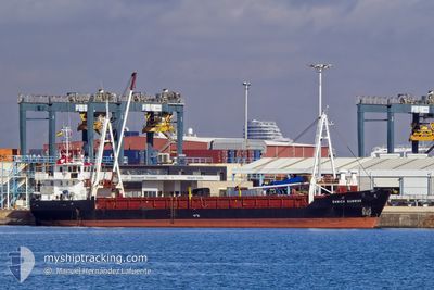
DANICA SUNRISE
General Cargo
Current Trip
| Time Travelled | 11 days |
|---|---|
| Remaining Time | --- |
| Distance Travelled | 2153.22 nm |
| Remaining Distance | --- |
| AVG Speed | 8 Knop |
| MAX Speed | 11.3 Knop |
| AVG Wind | 7.3 knots |
| MAX Wind | 14.9 knots |
| MIN Temp | 27.1°C / 80.78°F |
| MAX Temp | 31.5°C / 88.7°F |
| Djupgående | 3.3 m |
| Position mottagen | 3 d sen |
Current Position
| Longitud | 120.15969° |
|---|---|
| Latitude | 14.67469° |
| Status | Under way using engine |
| Fart | 8.3 Knop |
| Kurs | 292.5° |
| Område | South China Sea |
| Station | T-AIS |
| Position mottagen | 3 d sen |
Info
Information
The current position of DANICA SUNRISE is in South China Sea with coordinates 14.67469° / 120.15969° as reported on 2024-05-15 05:27 by AIS to our vessel tracker app. The vessel's current speed is 8.3 Knop and is heading at the port of SUBIC. The estimated time of arrival as calculated by MyShipTracking vessel tracking app is 2024-05-14 14:00 LT
The vessel DANICA SUNRISE (IMO: 8702410, MMSI: 219209000) is a General Cargo that was built in 1989 ( 35 År gammal ). It's sailing under the flag of [DK] Denmark.
In this page you can find informations about the vessels current position, last detected port calls, and current voyage information. If the vessels is not in coverage by AIS you will find the latest position.
The current position of DANICA SUNRISE is detected by our AIS receivers and we are not responsible for the reliability of the data. The last position was recorded while the vessel was in Coverage by the Ais receivers of our vessel tracking app.
The current draught of DANICA SUNRISE as reported by AIS is 3.3 meters
Weather
| Temperature | 29.3°C / 84.74°F |
|---|---|
| Wind Speed | 6 knots |
| Direction | 155° SSE |
| Pressure | 1004.4 hPa |
| Humidity | 74.8 % |
| Cloud Coverage | 89 % |
Featured Company
Last Port Calls
| Port | Arrival | Departure | Time In Port |
|---|---|---|---|
| 2024-05-07 06:40 | 2024-05-07 13:40 | 7 h | |
| 2024-04-05 13:50 | 2024-04-06 17:16 | 1 d |
Last Trips
| Origin | Departure | Destination | Arrival | Distance | |
|---|---|---|---|---|---|
| 2024-04-06 17:16 | 2024-05-07 06:40 | 5319.73 nm | |||
| 2024-02-16 19:43 | 2024-04-05 13:50 | 5748.79 nm |
Events
| Tid | Event | Detaljer | Position / Dest | Information |
|---|---|---|---|---|
| 2024-05-15 05:32 | Status ändrad | Default Under way using engine |
14.67667 / 120.14833
SUBIC BAY
|
Fart: 8.3 kn Kurs: 292.5° |
| 2024-05-15 05:27 | Status ändrad | Under way using engine Default |
14.67469 / 120.15969
SUBIC BAY
|
Fart: 8.7 kn Kurs: 192° |
| 2024-05-15 05:27 | UTANFÖR täckningsområde |
14.67469 / 120.15969
South China Sea
|
Fart: 8.3 kn Kurs: 292.5° |
|
| 2024-05-15 05:09 | I täckningsområde |
14.67469 / 120.15969
South China Sea
|
Fart: 8.3 kn Kurs: 292.5° |
|
| 2024-05-15 04:21 | Status ändrad | Default Under way using engine |
14.79853 / 120.23154
SUBIC BAY
|
Fart: 8.8 kn Kurs: 230.6° |
| 2024-05-15 04:15 | Status ändrad | Under way using engine Default |
14.80830 / 120.24328
SUBIC BAY
|
Fart: 5.3 kn Kurs: 295° |
| 2024-05-15 04:15 | UTANFÖR täckningsområde |
14.80830 / 120.24328
South China Sea
|
Fart: 8.8 kn Kurs: 230.6° |
|
| 2024-05-15 04:09 | Status ändrad | Default Under way using engine |
14.81320 / 120.25324
SUBIC BAY
|
Fart: 6.1 kn Kurs: 296° |
| 2024-05-15 04:06 | Status ändrad | Under way using engine Default |
14.81120 / 120.25749
SUBIC BAY
|
Fart: 6.7 kn Kurs: 308° |
| 2024-05-15 04:00 | STARTAR förflyttning | 0.9 nm, South West of GRANDE ISLAND |
14.80520 / 120.26666
SUBIC BAY
|
Fart: 4.9 kn Kurs: 315° |