
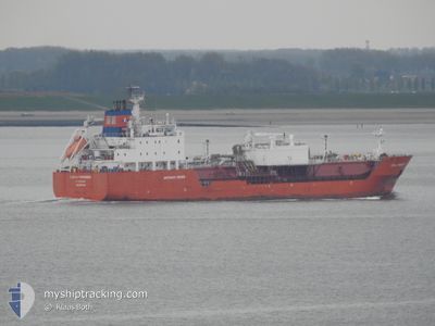
CORAL PARENSIS
Lpg Tanker
Current Trip
IT VDA
| Time Travelled | 2 days |
|---|---|
| Remaining Time | --- |
| Distance Travelled | 864.18 nm |
| Remaining Distance | --- |
| AVG Speed | 14.3 Knop |
| MAX Speed | 17.3 Knop |
| AVG Wind | 11.1 knots |
| MAX Wind | 25 knots |
| MIN Temp | 16.8°C / 62.24°F |
| MAX Temp | 23.6°C / 74.48°F |
| Djupgående | 7.4 m |
| Position mottagen | 3 m sen |
Current Position
| Longitud | --- |
|---|---|
| Latitude | --- |
| Status | Under way using engine |
| Fart | 13.4 Knop |
| Kurs | 84.7° |
| Område | Tyrrhenian Sea |
| Station | T-AIS |
| Position mottagen | 3 m sen |
Info
Information
The current position of CORAL PARENSIS is in Tyrrhenian Sea with coordinates 43.29288° / 9.92254° as reported on 2024-10-06 09:19 by AIS to our vessel tracker app. The vessel's current speed is 13.4 Knop
The vessel CORAL PARENSIS (IMO: 9208148, MMSI: 246605000) is a Lpg Tanker that was built in 2000 ( 24 År gammal ). It's sailing under the flag of [NL] Netherlands.
In this page you can find informations about the vessels current position, last detected port calls, and current voyage information. If the vessels is not in coverage by AIS you will find the latest position.
The current position of CORAL PARENSIS is detected by our AIS receivers and we are not responsible for the reliability of the data. The last position was recorded while the vessel was in Coverage by the Ais receivers of our vessel tracking app.
The current draught of CORAL PARENSIS as reported by AIS is 7.4 meters
Weather
| Temperature | 18.5°C / 65.3°F |
|---|---|
| Wind Speed | 5 knots |
| Direction | 153° SSE |
| Pressure | 1013.4 hPa |
| Humidity | 63.8 % |
| Cloud Coverage | 100 % |
Featured Company
Last Port Calls
| Port | Arrival | Departure | Time In Port |
|---|---|---|---|
| 2024-10-03 17:05 | 2024-10-03 22:05 | 4 h | |
| 2024-09-25 10:56 | 2024-09-26 08:27 | 21 h | |
| 2024-09-21 22:46 | 2024-09-23 18:53 | 1 d | |
| 2024-09-20 09:24 | 2024-09-21 17:18 | 1 d | |
| 2024-09-17 15:05 | 2024-09-18 12:12 | 21 h | |
| 2024-09-05 09:36 | 2024-09-05 20:16 | 10 h |
Last Trips
| Origin | Departure | Destination | Arrival | Distance | |
|---|---|---|---|---|---|
| 2024-09-26 08:27 | 2024-10-03 17:05 | 1903.86 nm | |||
| 2024-09-23 18:53 | 2024-09-25 10:56 | 554.43 nm | |||
| 2024-09-21 17:18 | 2024-09-21 22:46 | 68.91 nm | |||
| 2024-09-18 12:12 | 2024-09-20 09:24 | 588.01 nm | |||
| 2024-09-05 20:16 | 2024-09-17 15:05 | 1890.81 nm | |||
| 2024-06-28 15:26 | 2024-09-05 09:36 | 1030.96 nm |
Events
| Tid | Event | Detaljer | Position / Dest | Information |
|---|---|---|---|---|
| 2024-10-06 09:03 | Status ändrad | Under way using engine Default |
43.29160 / 9.83784
IT VDA
|
Fart: 13.9 kn Kurs: 86° |
| 2024-10-06 08:51 | Status ändrad | Default Under way using engine |
43.29179 / 9.77322
IT VDA
|
Fart: 13.9 kn Kurs: 86.2° |
| 2024-10-06 08:46 | Upptäckt i hav | Italian part of the Tyrrhenian Sea |
43.29083 / 9.75128
Tyrrhenian Sea
IT VDA
|
Fart: 13.9 kn Kurs: 86.2° |
| 2024-10-06 08:42 | Status ändrad | Under way using engine Default |
43.28974 / 9.72734
IT VDA
|
Fart: 13.7 kn Kurs: 89° |
| 2024-10-06 08:20 | Status ändrad | Default Under way using engine |
43.28653 / 9.61360
IT VDA
|
Fart: 13.7 kn Kurs: 88.4° |
| 2024-10-06 08:05 | Byter havsområde | Italian part of the Ligurian Sea French part of the Ligurian Sea |
43.28482 / 9.53158
Ligurian Sea
IT VDA
|
Fart: 13.8 kn Kurs: 88.3° |
| 2024-10-06 07:04 | Upptäckt i hav | French part of the Ligurian Sea |
43.27799 / 9.21169
Ligurian Sea
IT VDA
|
Fart: 13.9 kn Kurs: 87.3° |
| 2024-10-06 07:04 | Status ändrad | Under way using engine Default |
43.27799 / 9.21169
IT VDA
|
Fart: 13.6 kn Kurs: 88° |
| 2024-10-06 07:04 | I täckningsområde |
43.27799 / 9.21169
Ligurian Sea
IT VDA
|
Fart: 13.9 kn Kurs: 87.3° |
|
| 2024-10-04 15:42 | UTANFÖR täckningsområde |
37.76741 / -.33632
Mediterranean Sea - Western Basin
IT VDA
|
Fart: 14.9 kn Kurs: 32.8° |