
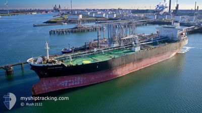
CLEAN NIRVANA
Crude Oil Tanker
Current Trip
TURKEY F.O
| Time Travelled | 7 days |
|---|---|
| Remaining Time | --- |
| Distance Travelled | 2251.54 nm |
| Remaining Distance | --- |
| AVG Speed | 11.8 Knop |
| MAX Speed | 15.9 Knop |
| AVG Wind | 11.5 knots |
| MAX Wind | 28.4 knots |
| MIN Temp | -0.5°C / 31.1°F |
| MAX Temp | 12.4°C / 54.32°F |
| Djupgående | 12.5 m |
| Position mottagen | 1 d sen |
Current Position
| Longitud | -5.20152° |
|---|---|
| Latitude | 49.09727° |
| Status | Under way using engine |
| Fart | 11.3 Knop |
| Kurs | 239.4° |
| Område | Celtic Sea |
| Station | T-AIS |
| Position mottagen | 1 d sen |
Info
Information
The current position of CLEAN NIRVANA is in Celtic Sea with coordinates 49.09727° / -5.20152° as reported on 2024-04-27 18:17 by AIS to our vessel tracker app. The vessel's current speed is 11.3 Knop
The vessel CLEAN NIRVANA (IMO: 9308168, MMSI: 352001148) is a Crude Oil Tanker that was built in 2008 ( 16 År gammal ). It's sailing under the flag of [PA] Panama.
In this page you can find informations about the vessels current position, last detected port calls, and current voyage information. If the vessels is not in coverage by AIS you will find the latest position.
The current position of CLEAN NIRVANA is detected by our AIS receivers and we are not responsible for the reliability of the data. The last position was recorded while the vessel was in Coverage by the Ais receivers of our vessel tracking app.
The current draught of CLEAN NIRVANA as reported by AIS is 12.5 meters
Weather
| Temperature | 12.3°C / 54.14°F |
|---|---|
| Wind Speed | 6 knots |
| Direction | 312° NW |
| Pressure | 1018.8 hPa |
| Humidity | 67.3 % |
| Cloud Coverage | 55 % |
Featured Company
Last Trips
| Origin | Departure | Destination | Arrival | Distance | |
|---|---|---|---|---|---|
| 2024-04-05 17:43 | 2024-04-20 04:14 | 2996.59 nm | |||
| 2024-02-15 16:57 | 2024-04-04 15:37 | 3949.64 nm | |||
| 2024-02-15 13:02 | 2024-02-15 13:27 | 1.31 nm | |||
| 2024-02-15 12:37 | 2024-02-15 12:53 | 2.78 nm |
Events
| Tid | Event | Detaljer | Position / Dest | Information |
|---|---|---|---|---|
| 2024-04-27 18:34 | Status ändrad | Default Under way using engine |
49.06833 / -5.27333
TURKEY F.O
|
Fart: 11.3 kn Kurs: 239.4° |
| 2024-04-27 18:17 | Upptäckt i hav | French part of the Celtic Sea |
49.09727 / -5.20152
Celtic Sea
TURKEY F.O
|
Fart: 11.3 kn Kurs: 239.4° |
| 2024-04-27 18:17 | Status ändrad | Under way using engine Default |
49.09727 / -5.20152
TURKEY F.O
|
Fart: 11 kn Kurs: 240° |
| 2024-04-27 18:17 | UTANFÖR täckningsområde |
49.09727 / -5.20152
Celtic Sea
TURKEY F.O
|
Fart: 11.3 kn Kurs: 239.4° |
|
| 2024-04-27 18:10 | I täckningsområde |
49.09727 / -5.20152
Celtic Sea
TURKEY F.O
|
Fart: 11.3 kn Kurs: 239.4° |
|
| 2024-04-27 17:13 | Status ändrad | Default Under way using engine |
49.19500 / -4.93667
TURKEY F.O
|
Fart: 11.3 kn Kurs: 241.5° |
| 2024-04-27 17:06 | Status ändrad | Under way using engine Default |
49.20640 / -4.90973
TURKEY F.O
|
Fart: 11 kn Kurs: 239° |
| 2024-04-27 17:06 | UTANFÖR täckningsområde |
49.20640 / -4.90973
English Channel
TURKEY F.O
|
Fart: 11.3 kn Kurs: 241.5° |
|
| 2024-04-27 16:20 | Status ändrad | Default Under way using engine |
49.28665 / -4.71619
TURKEY F.O
|
Fart: 11.9 kn Kurs: 237.8° |
| 2024-04-27 16:05 | Status ändrad | Under way using engine Default |
49.31400 / -4.65122
TURKEY F.O
|
Fart: 12 kn Kurs: 237° |