
CITRUS VITA BRASIL
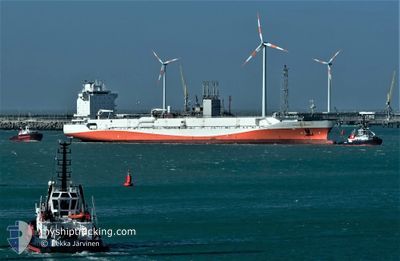
Container Ship
Current Trip
| Time Travelled | 6 days |
|---|---|
| Remaining Time | --- |
| Distance Travelled | 2252.06 nm |
| Remaining Distance | --- |
| AVG Speed | 14.4 Knop |
| MAX Speed | 18.2 Knop |
| AVG Wind | 10.2 knots |
| MAX Wind | 23 knots |
| MIN Temp | 22.1°C / 71.78°F |
| MAX Temp | 27.8°C / 82.04°F |
| Djupgående | 11.4 m |
| Position mottagen | 2 d sen |
Current Position
| Longitud | --- |
|---|---|
| Latitude | --- |
| Status | Under way using engine |
| Fart | 14.6 Knop |
| Kurs | 18.7° |
| Område | South Atlantic Ocean |
| Station | T-AIS |
| Position mottagen | 2 d sen |
Info
Information
The current position of CITRUS VITA BRASIL is in South Atlantic Ocean with coordinates -4.49510° / -33.02684° as reported on 2024-10-16 04:07 by AIS to our vessel tracker app. The vessel's current speed is 14.6 Knop and is heading at the port of ZEEBRUGGE. The estimated time of arrival as calculated by MyShipTracking vessel tracking app is 2024-10-27 18:30 LT
The vessel CITRUS VITA BRASIL (IMO: 9491836, MMSI: 636017610) is a Container Ship that was built in 2009 ( 15 År gammal ). It's sailing under the flag of [LR] Liberia.
In this page you can find informations about the vessels current position, last detected port calls, and current voyage information. If the vessels is not in coverage by AIS you will find the latest position.
The current position of CITRUS VITA BRASIL is detected by our AIS receivers and we are not responsible for the reliability of the data. The last position was recorded while the vessel was in Coverage by the Ais receivers of our vessel tracking app.
The current draught of CITRUS VITA BRASIL as reported by AIS is 11.4 meters
Weather
| Temperature | 27°C / 80.6°F |
|---|---|
| Wind Speed | 5 knots |
| Direction | 170° S |
| Pressure | 1011.1 hPa |
| Humidity | 77.7 % |
| Cloud Coverage | 100 % |
Featured Company
Last Port Calls
| Port | Arrival | Departure | Time In Port |
|---|---|---|---|
| 2024-10-08 08:32 | 2024-10-11 13:19 | 3 d | |
| 2024-09-16 13:55 | 2024-09-21 12:54 | 4 d | |
| 2024-08-26 09:57 | 2024-08-29 17:00 | 3 d | |
| 2024-08-07 08:25 |
Most Visited Ports (Last year)
| Port | Arrivals | |
|---|---|---|
| 7 | ||
| 4 | ||
| 3 | ||
| 1 | ||
| 1 | ||
| 1 |
Last Trips
| Origin | Departure | Destination | Arrival | Distance | |
|---|---|---|---|---|---|
| 2024-09-21 12:54 | 2024-10-08 08:32 | 5135.33 nm | |||
| 2024-08-29 17:00 | 2024-09-16 13:55 | 5154.37 nm | |||
| 2024-08-07 08:25 | 2024-08-26 09:57 | 5255.06 nm |
Events
| Tid | Event | Detaljer | Position / Dest | Information |
|---|---|---|---|---|
| 2024-10-16 04:12 | Status ändrad | Default Under way using engine |
-4.47332 / -33.01975
BE ZEE
|
Fart: 14.6 kn Kurs: 18.7° |
| 2024-10-16 04:07 | Status ändrad | Under way using engine Default |
-4.49510 / -33.02684
BE ZEE
|
Fart: 14.6 kn Kurs: 18° |
| 2024-10-16 04:07 | UTANFÖR täckningsområde |
-4.49510 / -33.02684
South Atlantic Ocean
BE ZEE
|
Fart: 14.6 kn Kurs: 18.7° |
|
| 2024-10-16 04:02 | Status ändrad | Default Under way using engine |
-4.51454 / -33.03323
BE ZEE
|
Fart: 14.6 kn Kurs: 18.8° |
| 2024-10-16 03:55 | Status ändrad | Under way using engine Default |
-4.53949 / -33.04135
BE ZEE
|
Fart: 14.6 kn Kurs: 19° |
| 2024-10-16 03:43 | Status ändrad | Default Under way using engine |
-4.58789 / -33.05701
BE ZEE
|
Fart: 14.7 kn Kurs: 19.8° |
| 2024-10-16 03:29 | Status ändrad | Under way using engine Default |
-4.66893 / -33.08314
BE ZEE
|
Fart: 14.7 kn Kurs: 17° |
| 2024-10-16 03:17 | I täckningsområde |
-4.66893 / -33.08314
South Atlantic Ocean
BE ZEE
|
Fart: 14.7 kn Kurs: 19.8° |
|
| 2024-10-16 02:33 | Status ändrad | Default Under way using engine |
-4.86162 / -33.14729
BE ZEE
|
Fart: 14.5 kn Kurs: 18.2° |
| 2024-10-16 02:29 | UTANFÖR täckningsområde |
-4.87710 / -33.15248
South Atlantic Ocean
BE ZEE
|
Fart: 14.5 kn Kurs: 18.2° |