
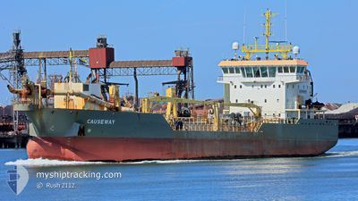
CAUSEWAY
Trailing Suction Hopper Dredger
Current Trip
| Time Travelled | 2 days |
|---|---|
| Remaining Time | --- |
| Distance Travelled | 215.86 nm |
| Remaining Distance | 63.29 nm |
| AVG Speed | 5.6 Knop |
| MAX Speed | 11.8 Knop |
| AVG Wind | 15.9 knots |
| MAX Wind | 25 knots |
| MIN Temp | 5.6°C / 42.08°F |
| MAX Temp | 7.9°C / 46.22°F |
| Djupgående | 4 m |
| Position mottagen | 1 m sen |
Current Position
| Longitud | --- |
|---|---|
| Latitude | --- |
| Status | Under way using engine |
| Fart | 4.5 Knop |
| Kurs | 148° |
| Område | North Sea |
| Station | T-AIS |
| Position mottagen | 1 m sen |
Info
Information
The current position of CAUSEWAY is in North Sea with coordinates 51.33568° / 2.06186° as reported on 2025-03-01 15:55 by AIS to our vessel tracker app. The vessel's current speed is 4.5 Knop and is heading at the port of VLISSINGEN.
The vessel CAUSEWAY (IMO: 9653197, MMSI: 210523000) is a Trailing Suction Hopper Dredger that was built in 2013 ( 12 År gammal ). It's sailing under the flag of [CY] Cyprus.
In this page you can find informations about the vessels current position, last detected port calls, and current voyage information. If the vessels is not in coverage by AIS you will find the latest position.
The current position of CAUSEWAY is detected by our AIS receivers and we are not responsible for the reliability of the data. The last position was recorded while the vessel was in Coverage by the Ais receivers of our vessel tracking app.
The current draught of CAUSEWAY as reported by AIS is 4 meters
Weather
| Temperature | 6.6°C / 43.88°F |
|---|---|
| Wind Speed | 12 knots |
| Direction | 55° NE |
| Pressure | 1034.1 hPa |
| Humidity | 73.7 % |
| Cloud Coverage | 5 % |
Featured Company
Last Port Calls
| Port | Arrival | Departure | Time In Port |
|---|---|---|---|
| 2025-02-26 04:53 | 2025-02-26 17:18 | 12 h | |
| 2025-02-23 13:13 | 2025-02-24 17:20 | 1 d | |
| 2025-02-19 05:39 | 2025-02-19 16:07 | 10 h | |
| 2025-02-12 09:42 | 2025-02-12 13:54 | 4 h | |
| 2025-02-03 05:43 | 2025-02-08 07:36 | 5 d | |
| 2025-02-01 16:20 | 2025-02-01 16:54 | 33 m | |
| 2025-01-31 13:42 | 2025-01-31 13:46 | 4 m | |
| 2025-01-31 13:25 | 2025-01-31 13:36 | 10 m | |
| 2025-01-31 05:43 | 2025-01-31 05:49 | 5 m | |
| 2025-01-30 18:40 | 2025-01-30 19:00 | 20 m |
Most Visited Ports (Last year)
| Port | Arrivals | |
|---|---|---|
| 143 | ||
| 135 | ||
| 129 | ||
| 44 | ||
| 31 | ||
| 30 |
Last Trips
| Origin | Departure | Destination | Arrival | Distance | |
|---|---|---|---|---|---|
| 2025-02-24 18:20 | 2025-02-26 05:53 | 116.77 nm | |||
| 2025-02-19 17:07 | 2025-02-23 14:13 | 301.13 nm | |||
| 2025-02-12 14:54 | 2025-02-19 06:39 | 559.73 nm | |||
| 2025-02-08 08:36 | 2025-02-12 10:42 | 332.98 nm | |||
| 2025-02-01 17:54 | 2025-02-03 06:43 | 288.92 nm | |||
| 2025-01-31 14:46 | 2025-02-01 17:20 | 186.23 nm | |||
| 2025-01-31 14:36 | 2025-01-31 14:42 | 0.43 nm | |||
| 2025-01-31 06:49 | 2025-01-31 14:25 | 63.97 nm | |||
| 2025-01-30 20:00 | 2025-01-31 06:43 | 80.60 nm | |||
| 2025-01-30 04:24 | 2025-01-30 19:40 | 114.30 nm |
Events
| Tid | Event | Detaljer | Position / Dest | Information |
|---|---|---|---|---|
| 2025-03-01 15:44 | Byter havsområde | French part of the North Sea United Kingdom part of the North Sea |
51.34497 / 2.04464
North Sea
|
Fart: 4.6 kn Kurs: 129.7° |
| 2025-03-01 14:29 | ETA ändrat | 2026/02/02 05:00 2026/02/08 04:00 |
51.42886 / 1.82414
VLISSINGEN
|
Fart: 6.6 kn Kurs: 70° |
| 2025-03-01 14:23 | Destination ändrad | VLISSINGEN DREDGING/SURVEY |
51.42479 / 1.80730
VLISSINGEN
|
Fart: 6.2 kn Kurs: 67.9° |
| 2025-03-01 13:22 | STARTAR förflyttning | 9.96 nm, North East of RAMSGATE |
51.38905 / 1.66597
DREDGING/SURVEY
|
Fart: 3.1 kn Kurs: 70° |
| 2025-03-01 13:19 | Status ändrad | Under way using engine Restricted manoeuverability |
51.38945 / 1.66465
DREDGING/SURVEY
|
Fart: 1.8 kn Kurs: 174° |
| 2025-03-01 13:02 | STOPPAR förflyttning | 9.97 nm, North East of RAMSGATE |
51.39544 / 1.66177
DREDGING/SURVEY
|
Fart: 0.3 kn Kurs: 174° |
| 2025-03-01 12:28 | STARTAR förflyttning | 10.68 nm, East of RAMSGATE |
51.38513 / 1.68884
DREDGING/SURVEY
|
Fart: 3.1 kn Kurs: 128° |
| 2025-03-01 11:54 | STOPPAR förflyttning | 9.93 nm, North East of RAMSGATE |
51.39461 / 1.66138
DREDGING/SURVEY
|
Fart: 0.2 kn Kurs: 130° |
| 2025-03-01 11:13 | STARTAR förflyttning | 10.98 nm, East of RAMSGATE |
51.38847 / 1.69542
DREDGING/SURVEY
|
Fart: 3.1 kn Kurs: 217° |
| 2025-03-01 10:20 | STOPPAR förflyttning | 10.66 nm, East of RAMSGATE |
51.38163 / 1.69024
DREDGING/SURVEY
|
Fart: 0.2 kn Kurs: 20° |