

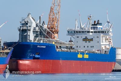
BULKNES
Self Discharging Bulk Carrier

Current Trip
| Trip Time | 2 days |
|---|---|
| Trip Distance | 692.89 nm |
| AVG Speed | 11.6 Knop |
| MAX Speed | 12.7 Knop |
| Djupgående | 10 m |
| AVG Wind | 14.3 knots |
| MAX Wind | 24 knots |
| MIN Temp | 0.4°C / 32.72°F |
| MAX Temp | 7.3°C / 45.14°F |
| Position mottagen | 2 m sen |
Current Position
| Longitud | --- |
|---|---|
| Latitude | --- |
| Status | Moored |
| Fart | |
| Kurs | 110° |
| Område | Skaggerak |
| Station | T-AIS |
| Position mottagen | 2 m sen |
Information
The current position of BULKNES is in Skaggerak with coordinates 59.06267° / 9.69450° as reported on 2025-03-28 14:38 by AIS to our vessel tracker app. The vessel's current speed is 0 Knop and is currently inside the port of BREVIK.
The vessel BULKNES (IMO: 9384370, MMSI: 305425000) is a Self Discharging Bulk Carrier that was built in 2009 ( 16 År gammal ). It's sailing under the flag of [AG] Antigua Barbuda.
In this page you can find informations about the vessels current position, last detected port calls, and current voyage information. If the vessels is not in coverage by AIS you will find the latest position.
The current position of BULKNES is detected by our AIS receivers and we are not responsible for the reliability of the data. The last position was recorded while the vessel was in Coverage by the Ais receivers of our vessel tracking app.
The current draught of BULKNES as reported by AIS is 6.7 meters
Weather
| Temperature | 7°C / 44.6°F |
|---|---|
| Wind Speed | 14 knots |
| Direction | 211° SSW |
| Pressure | 1002.5 hPa |
| Humidity | 89.7 % |
| Cloud Coverage | 100 % |


Featured Company
Last Port Calls
| Port | Arrival | Departure | Time In Port |
|---|---|---|---|
| 2025-03-28 00:53 | |||
| 2025-03-24 14:25 | 2025-03-25 08:37 | 18 h | |
| 2025-03-21 16:50 | 2025-03-21 21:21 | 4 h | |
| 2025-03-13 17:39 | 2025-03-14 11:35 | 17 h | |
| 2025-03-01 17:15 | 2025-03-01 22:33 | 5 h | |
| 2025-02-24 08:31 | 2025-02-25 02:36 | 18 h | |
| 2025-02-21 14:29 | 2025-02-22 07:22 | 16 h | |
| 2025-02-18 18:57 | 2025-02-19 10:13 | 15 h | |
| 2025-02-14 08:04 | 2025-02-14 21:07 | 13 h | |
| 2025-02-13 20:58 | 2025-02-14 07:40 | 10 h |
Last Trips
| Origin | Departure | Destination | Arrival | Distance | |
|---|---|---|---|---|---|
| 2025-03-25 08:37 | 2025-03-28 00:53 | 692.89 nm | |||
| 2025-03-21 21:21 | 2025-03-24 14:25 | 822.36 nm | |||
| 2025-03-14 11:35 | 2025-03-21 16:50 | 1344.41 nm | |||
| 2025-03-01 22:33 | 2025-03-13 17:39 | 2211.70 nm | |||
| 2025-02-25 02:36 | 2025-03-01 17:15 | 950.64 nm | |||
| 2025-02-22 07:22 | 2025-02-24 08:31 | 535.95 nm | |||
| 2025-02-19 10:13 | 2025-02-21 14:29 | 569.65 nm | |||
| 2025-02-14 21:07 | 2025-02-18 18:57 | 491.80 nm | |||
| 2025-02-14 07:40 | 2025-02-14 08:04 | 0.54 nm | |||
| 2025-02-03 16:36 | 2025-02-13 20:58 | 1736.56 nm |
Events
| Tid | Event | Detaljer | Position / Dest | Information |
|---|---|---|---|---|
| 2025-03-28 01:37 | Djupgående ändrat | 6.7 10 |
59.06267 / 9.69483
[NO] BREVIK
|
Fart: 0.1 kn Kurs: 110° |
| 2025-03-28 01:37 | ETA ändrat | 2025/03/29 21:00 2025/03/27 23:00 |
59.06267 / 9.69483
[NO] BREVIK
|
Fart: 0.1 kn Kurs: 110° |
| 2025-03-28 01:30 | Destination ändrad | NOJEL NOBVK |
59.06267 / 9.69467
[NO] BREVIK
|
Fart: Kurs: 110° |
| 2025-03-28 00:38 | Status ändrad | Moored Under way using engine |
59.06250 / 9.69483
[NO] BREVIK
|
Fart: 0.1 kn Kurs: 108° |
| 2025-03-28 00:14 | STOPPAR förflyttning |
59.06233 / 9.69533
[NO] BREVIK
|
Fart: 0.3 kn Kurs: 106° |
|
| 2025-03-27 23:53 | ANLÄNDER HAMN |
|
59.05883 / 9.70517
[NO] BREVIK
|
Fart: 5.4 kn Kurs: 315° |
| 2025-03-27 22:10 | ETA ändrat | 2025/03/27 23:00 2025/03/27 21:00 |
58.77717 / 9.76617
NOBVK
|
Fart: 11.6 kn Kurs: 4° |
| 2025-03-27 13:14 | Byter havsområde | Norwegian part of the Skaggerak Norwegian part of the North Sea |
57.71367 / 7.52250
Skaggerak
NOBVK
|
Fart: 11.7 kn Kurs: 95° |
| 2025-03-26 13:21 | Byter havsområde | Norwegian part of the North Sea Norwegian part of the Norwegian Sea |
60.99933 / 4.02700
North Sea
NOBVK
|
Fart: 10.1 kn Kurs: 178° |
| 2025-03-26 11:41 | ETA ändrat | 2025/03/27 21:00 2025/03/27 17:30 |
61.29417 / 4.06250
NOBVK
|
Fart: 11.1 kn Kurs: 186° |