
Unkown Name
Military ops
Current Trip
Unknown
| Time Travelled | 5 days |
|---|---|
| Remaining Time | --- |
| Distance Travelled | 310.21 nm |
| Remaining Distance | --- |
| AVG Speed | 11.7 Knop |
| MAX Speed | 11.7 Knop |
| AVG Wind | 4.7 knots |
| MAX Wind | 9.8 knots |
| MIN Temp | 9.7°C / 49.46°F |
| MAX Temp | 16.8°C / 62.24°F |
| Djupgående | 25.5 m |
| Position mottagen | 3 d sen |
Current Position
| Longitud | -5.10928° |
|---|---|
| Latitude | 55.38059° |
| Status | Under way using engine |
| Fart | 21 Knop |
| Kurs | 231.9° |
| Område | Inner Seas off the West Coast of Scotland |
| Station | T-AIS |
| Position mottagen | 3 d sen |
Info
Information
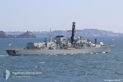
The current position of Unkown Name is in Inner Seas off the West Coast of Scotland with coordinates 55.38059° / -5.10928° as reported on 2024-05-14 18:59 by AIS to our vessel tracker app. The vessel's current speed is 21 Knop
The vessel Unkown Name (MMSI: 234630000) is a Military ops It's sailing under the flag of [GB] United Kingdom.
In this page you can find informations about the vessels current position, last detected port calls, and current voyage information. If the vessels is not in coverage by AIS you will find the latest position.
The current position of Unkown Name is detected by our AIS receivers and we are not responsible for the reliability of the data. The last position was recorded while the vessel was in Coverage by the Ais receivers of our vessel tracking app.
The current draught of Unkown Name as reported by AIS is 25.5 meters
Weather
| Temperature | 12.2°C / 53.96°F |
|---|---|
| Wind Speed | 2 knots |
| Direction | 12° NNE |
| Pressure | 1000.5 hPa |
| Humidity | 98.7 % |
| Cloud Coverage | 100 % |
Featured Company
Last Trips
| Origin | Departure | Destination | Arrival | Distance | |
|---|---|---|---|---|---|
| 2024-05-08 14:18 | 2024-05-09 16:38 | 373.56 nm | |||
| 2024-03-24 19:17 | 2024-03-27 16:25 | 899.09 nm | |||
| 2024-03-13 11:21 | 2024-03-23 09:50 | 2605.65 nm | |||
| 2024-03-13 11:21 | 2024-03-15 05:14 | 608.31 nm | |||
| 2024-01-30 08:40 | 2024-03-11 11:09 | 639.19 nm |
Events
| Tid | Event | Detaljer | Position / Dest | Information |
|---|---|---|---|---|
| 2024-05-14 18:59 | UTANFÖR täckningsområde |
55.38059 / -5.10928
Inner Seas off the West Coast of Scotland
|
Fart: 21 kn Kurs: 231.9° |
|
| 2024-05-14 17:38 | I täckningsområde |
55.74446 / -5.17769
Inner Seas off the West Coast of Scotland
|
Fart: 20.5 kn Kurs: 140.5° |
|
| 2024-05-14 16:05 | UTANFÖR täckningsområde |
56.14525 / -5.17330
Inner Seas off the West Coast of Scotland
|
Fart: 16.1 kn Kurs: 246.4° |
|
| 2024-05-14 06:56 | STARTAR förflyttning | 9.71 nm, North West of FINNART |
56.21837 / -5.06177
|
Fart: 8.8 kn Kurs: 210.7° |
| 2024-05-14 06:40 | I täckningsområde |
56.23002 / -5.05025
Inner Seas off the West Coast of Scotland
|
Fart: 0.2 kn Kurs: 301.1° |
|
| 2024-05-13 23:27 | UTANFÖR täckningsområde |
56.22984 / -5.05744
Inner Seas off the West Coast of Scotland
|
Fart: 0.1 kn Kurs: 294.6° |
|
| 2024-05-13 22:09 | I täckningsområde |
56.22984 / -5.05765
Inner Seas off the West Coast of Scotland
|
Fart: 0.1 kn Kurs: 84.5° |
|
| 2024-05-13 21:00 | UTANFÖR täckningsområde |
56.22977 / -5.05816
Inner Seas off the West Coast of Scotland
|
Fart: 0.2 kn Kurs: 256.5° |
|
| 2024-05-13 20:51 | STOPPAR förflyttning | 10.05 nm, North West of GLEN MALLAN |
56.22979 / -5.05812
|
Fart: 0.2 kn Kurs: 1° |
| 2024-05-13 19:11 | Status ändrad | Moored Under way using engine |
56.22979 / -5.05894
|
Fart: 0.6 kn Kurs: 20° |