
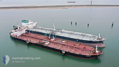
BOTAFOGO
Crude Oil Tanker
Current Trip
| Time Travelled | 2 days |
|---|---|
| Remaining Time | --- |
| Distance Travelled | 535.77 nm |
| Remaining Distance | --- |
| AVG Speed | 7.4 Knop |
| MAX Speed | 10.5 Knop |
| AVG Wind | 15.2 knots |
| MAX Wind | 26.8 knots |
| MIN Temp | 8.9°C / 48.02°F |
| MAX Temp | 12.5°C / 54.5°F |
| Djupgående | 7.3 m |
| Position mottagen | Nu |
Current Position
| Longitud | 2.32449° |
|---|---|
| Latitude | 51.58756° |
| Status | Under way using engine |
| Fart | 5.1 Knop |
| Kurs | 38.8° |
| Område | North Sea |
| Station | T-AIS |
| Position mottagen | Nu |
Info
Information
The current position of BOTAFOGO is in North Sea with coordinates 51.58756° / 2.32449° as reported on 2024-05-03 02:25 by AIS to our vessel tracker app. The vessel's current speed is 5.1 Knop and is heading at the port of SOUTHWOLD. The estimated time of arrival as calculated by MyShipTracking vessel tracking app is 2024-05-03 11:00 LT
The vessel BOTAFOGO (IMO: 9395329, MMSI: 249575000) is a Crude Oil Tanker that was built in 2010 ( 14 År gammal ). It's sailing under the flag of [MT] Malta.
In this page you can find informations about the vessels current position, last detected port calls, and current voyage information. If the vessels is not in coverage by AIS you will find the latest position.
The current position of BOTAFOGO is detected by our AIS receivers and we are not responsible for the reliability of the data. The last position was recorded while the vessel was in Coverage by the Ais receivers of our vessel tracking app.
The current draught of BOTAFOGO as reported by AIS is 7.3 meters
Weather
| Temperature | 11°C / 51.8°F |
|---|---|
| Wind Speed | 19 knots |
| Direction | 259° W |
| Pressure | 1004.5 hPa |
| Humidity | 92.7 % |
| Cloud Coverage | 100 % |
Featured Company
Last Trips
| Origin | Departure | Destination | Arrival | Distance | |
|---|---|---|---|---|---|
| 2024-04-28 20:09 | 2024-04-30 08:20 | 0.49 nm | |||
| 2024-04-28 20:09 | 2024-04-28 20:20 | 0.11 nm | |||
| 2024-04-12 06:58 | 2024-04-28 19:44 | 4746.73 nm | |||
| 2024-03-03 18:09 | 2024-04-09 12:57 | 7468.13 nm | |||
| 2024-01-10 11:28 | 2024-03-02 09:27 | 2122.77 nm |
Events
| Tid | Event | Detaljer | Position / Dest | Information |
|---|---|---|---|---|
| 2024-05-03 01:40 | Byter havsområde | Belgian part of the North Sea French part of the North Sea |
51.53778 / 2.25326
North Sea
IEORK>GBSWD
|
Fart: 5.4 kn Kurs: 42.3° |
| 2024-05-03 01:00 | ETA ändrat | 2024/05/03 11:00 2024/05/03 09:00 |
51.48790 / 2.18977
IEORK>GBSWD
|
Fart: 5.6 kn Kurs: 36.3° |
| 2024-05-02 23:49 | Byter havsområde | French part of the North Sea United Kingdom part of the North Sea |
51.39597 / 2.06832
North Sea
IEORK>GBSWD
|
Fart: 6 kn Kurs: 37.5° |
| 2024-05-02 22:03 | Djupgående ändrat | 7.3 7 |
51.24766 / 1.86696
IEORK>GBSWD
|
Fart: 7.1 kn Kurs: 42.3° |
| 2024-05-02 22:03 | ETA ändrat | 2024/05/03 09:00 |
51.24766 / 1.86696
IEORK>GBSWD
|
Fart: 7.1 kn Kurs: 42.3° |
| 2024-05-02 21:57 | Djupgående ändrat | 7 7.3 |
51.23871 / 1.85387
IEORK>GBSWD
|
Fart: 7.2 kn Kurs: 43.7° |
| 2024-05-02 21:51 | Djupgående ändrat | 7.3 7 |
51.22972 / 1.84079
IEORK>GBSWD
|
Fart: 7.2 kn Kurs: 42.6° |
| 2024-05-02 21:51 | ETA ändrat | 2024/05/03 09:00 |
51.22972 / 1.84079
IEORK>GBSWD
|
Fart: 7.2 kn Kurs: 42.6° |
| 2024-05-02 21:45 | Djupgående ändrat | 7 7.3 |
51.22064 / 1.82770
IEORK>GBSWD
|
Fart: 7.1 kn Kurs: 42° |
| 2024-05-02 21:39 | Djupgående ändrat | 7.3 7 |
51.21148 / 1.81458
IEORK>GBSWD
|
Fart: 7.1 kn Kurs: 43° |