
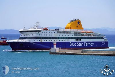
BLUE STAR PATMOS
Ro-Ro/Passenger Ship
Current Trip
| Trip Time | 3 h, 48 mins |
|---|---|
| Trip Distance | 67.65 nm |
| AVG Speed | 22.9 Knop |
| MAX Speed | 25.3 Knop |
| Djupgående | 5.9 m |
| AVG Wind | 4.1 knots |
| MAX Wind | 7.5 knots |
| MIN Temp | 24.1°C / 75.38°F |
| MAX Temp | 25.4°C / 77.72°F |
| Position mottagen | 13 m sen |
Current Position
| Longitud | 28.23701° |
|---|---|
| Latitude | 36.44640° |
| Status | Under way using engine |
| Fart | 2.3 Knop |
| Kurs | 323° |
| Område | Aegean Sea |
| Station | T-AIS |
| Position mottagen | 13 m sen |
Info
Information
The current position of BLUE STAR PATMOS is in Aegean Sea with coordinates 36.44640° / 28.23701° as reported on 2024-06-21 06:07 by AIS to our vessel tracker app. The vessel's current speed is 2.3 Knop and is currently inside the port of RHODES.
The vessel BLUE STAR PATMOS (IMO: 9565041, MMSI: 241159000) is a Ro-Ro/Passenger Ship that was built in 2012 ( 12 År gammal ). It's sailing under the flag of [GR] Greece.
In this page you can find informations about the vessels current position, last detected port calls, and current voyage information. If the vessels is not in coverage by AIS you will find the latest position.
The current position of BLUE STAR PATMOS is detected by our AIS receivers and we are not responsible for the reliability of the data. The last position was recorded while the vessel was in Coverage by the Ais receivers of our vessel tracking app.
The current draught of BLUE STAR PATMOS as reported by AIS is 5.9 meters
Weather
| Temperature | 24.8°C / 76.64°F |
|---|---|
| Wind Speed | 5 knots |
| Direction | 291° WNW |
| Pressure | 1006.2 hPa |
| Humidity | 79.8 % |
| Cloud Coverage | 1 % |
Featured Company
Last Port Calls
| Port | Arrival | Departure | Time In Port |
|---|---|---|---|
| 2024-06-21 06:02 | |||
| 2024-06-21 01:57 | 2024-06-21 02:14 | 16 m | |
| 2024-06-20 23:17 | 2024-06-20 23:55 | 38 m | |
| 2024-06-20 05:10 | 2024-06-20 11:17 | 6 h | |
| 2024-06-19 21:17 | 2024-06-19 21:35 | 18 m | |
| 2024-06-19 20:00 | 2024-06-19 20:38 | 38 m | |
| 2024-06-19 18:28 | 2024-06-19 19:09 | 41 m | |
| 2024-06-19 06:15 | 2024-06-19 13:07 | 6 h | |
| 2024-06-19 01:13 | 2024-06-19 01:46 | 33 m | |
| 2024-06-18 23:41 | 2024-06-19 00:41 | 59 m |
Last Trips
| Origin | Departure | Destination | Arrival | Distance | |
|---|---|---|---|---|---|
| 2024-06-21 05:14 | 2024-06-21 09:02 | 67.65 nm | |||
| 2024-06-21 02:55 | 2024-06-21 04:57 | 38.34 nm | |||
| 2024-06-20 14:17 | 2024-06-21 02:17 | 209.80 nm | |||
| 2024-06-20 00:35 | 2024-06-20 08:10 | 168.27 nm | |||
| 2024-06-19 23:38 | 2024-06-20 00:17 | 8.60 nm | |||
| 2024-06-19 22:09 | 2024-06-19 23:00 | 18.54 nm | |||
| 2024-06-19 16:07 | 2024-06-19 21:28 | 75.14 nm | |||
| 2024-06-19 04:46 | 2024-06-19 09:15 | 68.80 nm | |||
| 2024-06-19 03:41 | 2024-06-19 04:13 | 12.16 nm | |||
| 2024-06-19 01:52 | 2024-06-19 02:41 | 13.34 nm |
Events
| Tid | Event | Detaljer | Position / Dest | Information |
|---|---|---|---|---|
| 2024-06-21 06:10 | Status ändrad | Default Under way using engine |
36.44591 / 28.23792
[GR] RHODES
|
Fart: 2.3 kn Kurs: 323° |
| 2024-06-21 06:02 | ANLÄNDER HAMN |
|
36.44918 / 28.23560
[GR] RHODES
|
Fart: 11.8 kn Kurs: 155° |
| 2024-06-21 06:01 | Byter havsområde | Greek part of the Mediterranean Sea - Eastern Basin Greek part of the Aegean Sea |
36.45502 / 28.23266
Mediterranean Sea - Eastern Basin
PAGKFPLKKNTSRK
|
Fart: 14.2 kn Kurs: 159.3° |
| 2024-06-21 05:42 | Byter havsområde | Greek part of the Aegean Sea Turkish part of the Aegean Sea |
36.50518 / 28.10404
Aegean Sea
PAGKFPLKKNTSRK
|
Fart: 24.5 kn Kurs: 104.9° |
| 2024-06-21 05:19 | Byter havsområde | Turkish part of the Aegean Sea Greek part of the Aegean Sea |
36.57449 / 27.93567
Aegean Sea
PAGKFPLKKNTSRK
|
Fart: 25.3 kn Kurs: 146.3° |
| 2024-06-21 03:29 | Status ändrad | Under way using engine Default |
36.43011 / 27.41080
PAGKFPLKKNTSRK
|
Fart: 21.9 kn Kurs: 223° |
| 2024-06-21 03:01 | Status ändrad | Default Under way using engine |
36.42841 / 27.40116
PAGKFPLKKNTSRK
|
Fart: 24.3 kn Kurs: 218.3° |
| 2024-06-21 02:14 | AVGÅTT HAMN |
|
36.63052 / 27.19913
PAGKFPLKKNTSRK
|
Fart: 1.9 kn Kurs: 118° |
| 2024-06-21 01:57 | ANLÄNDER HAMN |
|
36.61790 / 27.14107
[GR] NISYROS
|
Fart: 8.5 kn Kurs: 212.6° |
| 2024-06-21 01:41 | Byter havsområde | Greek part of the Aegean Sea Turkish part of the Aegean Sea |
36.69934 / 27.22444
Aegean Sea
PAGKFPLKKNTSRK
|
Fart: 24.6 kn Kurs: 219.6° |