
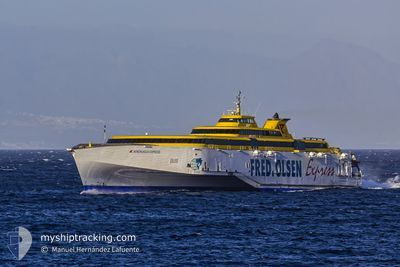
BENCHIJIGUA EXPRESS
Ro-Ro/Passenger Ship
Current Trip
| Time Travelled | 39 mins |
|---|---|
| Remaining Time | 1 h, 34 mins |
| Distance Travelled | --- |
| Remaining Distance | --- |
| AVG Speed | --- |
| MAX Speed | --- |
| AVG Wind | --- |
| MAX Wind | --- |
| MIN Temp | --- |
| MAX Temp | --- |
| Djupgående | 4.1 m |
| Position mottagen | 10 h, 39 m sen |
Current Position
| Longitud | --- |
|---|---|
| Latitude | --- |
| Status | Under way using engine |
| Fart | 29.7 Knop |
| Kurs | 306.2° |
| Område | North Atlantic Ocean |
| Station | T-AIS |
| Position mottagen | 10 h, 39 m sen |
Info
Information
The current position of BENCHIJIGUA EXPRESS is in North Atlantic Ocean with coordinates 28.35799° / -17.32231° as reported on 2024-11-27 20:31 by AIS to our vessel tracker app. The vessel's current speed is 29.7 Knop and is heading at the port of LOS CRISTIANOS. The estimated time of arrival as calculated by MyShipTracking vessel tracking app is 2024-11-28 08:45 LT
The vessel BENCHIJIGUA EXPRESS (IMO: 9299056, MMSI: 224441000) is a Ro-Ro/Passenger Ship that was built in 2005 ( 19 År gammal ). It's sailing under the flag of [ES] Spain.
In this page you can find informations about the vessels current position, last detected port calls, and current voyage information. If the vessels is not in coverage by AIS you will find the latest position.
The current position of BENCHIJIGUA EXPRESS is detected by our AIS receivers and we are not responsible for the reliability of the data. The last position was recorded while the vessel was in Coverage by the Ais receivers of our vessel tracking app.
The current draught of BENCHIJIGUA EXPRESS as reported by AIS is 4.1 meters
Weather
| Temperature | 21.2°C / 70.16°F |
|---|---|
| Wind Speed | 2 knots |
| Direction | 315° NW |
| Pressure | 1017.3 hPa |
| Humidity | 69.2 % |
| Cloud Coverage | 100 % |
Featured Company
Last Port Calls
| Port | Arrival | Departure | Time In Port |
|---|---|---|---|
| 2024-11-27 21:45 | 2024-11-28 06:32 | 8 h | |
| 2024-11-27 18:16 | 2024-11-27 19:07 | 51 m | |
| 2024-11-27 16:49 | 2024-11-27 17:33 | 44 m | |
| 2024-11-27 14:50 | 2024-11-27 16:05 | 1 h | |
| 2024-11-27 10:20 | 2024-11-27 14:03 | 3 h | |
| 2024-11-27 08:48 | 2024-11-27 09:34 | 45 m | |
| 2024-11-26 21:33 | 2024-11-27 06:30 | 8 h | |
| 2024-11-26 18:16 | 2024-11-26 19:06 | 50 m | |
| 2024-11-26 16:49 | 2024-11-26 17:34 | 44 m | |
| 2024-11-26 14:49 | 2024-11-26 16:07 | 1 h |
Most Visited Ports (Last year)
| Port | Arrivals | |
|---|---|---|
| 980 | ||
| 629 | ||
| 360 | ||
| 1 |
Last Trips
| Origin | Departure | Destination | Arrival | Distance | |
|---|---|---|---|---|---|
| 2024-11-27 19:07 | 2024-11-27 21:45 | 71.29 nm | |||
| 2024-11-27 17:33 | 2024-11-27 18:16 | 23.61 nm | |||
| 2024-11-27 16:05 | 2024-11-27 16:49 | 23.16 nm | |||
| 2024-11-27 14:03 | 2024-11-27 14:50 | 22.97 nm | |||
| 2024-11-27 09:34 | 2024-11-27 10:20 | 23.56 nm | |||
| 2024-11-27 06:30 | 2024-11-27 08:48 | 70.27 nm | |||
| 2024-11-26 19:06 | 2024-11-26 21:33 | 72.41 nm | |||
| 2024-11-26 17:34 | 2024-11-26 18:16 | 22.82 nm | |||
| 2024-11-26 16:07 | 2024-11-26 16:49 | 22.60 nm | |||
| 2024-11-26 14:04 | 2024-11-26 14:49 | 23.13 nm |
Events
| Tid | Event | Detaljer | Position / Dest | Information |
|---|---|---|---|---|
| 2024-11-28 06:32 | AVGÅTT HAMN |
|
28.57842 / -17.63739
CRT_GMR_SPC
|
Fart: Kurs: 262° |
| 2024-11-27 21:45 | STOPPAR förflyttning |
28.67778 / -17.76693
[ES] LA PALMA
|
Fart: 0.2 kn Kurs: 263° |
|
| 2024-11-27 21:45 | ANLÄNDER HAMN |
|
28.67778 / -17.76693
[ES] LA PALMA
|
Fart: 27.6 kn Kurs: 306° |
| 2024-11-27 20:39 | Status ändrad | Default Under way using engine |
28.39570 / -17.37891
CRT_GMR_SPC
|
Fart: 29.7 kn Kurs: 306.2° |
| 2024-11-27 20:31 | UTANFÖR täckningsområde |
28.35799 / -17.32231
North Atlantic Ocean
|
Fart: 29.7 kn Kurs: 306.2° |
|
| 2024-11-27 19:07 | AVGÅTT HAMN |
|
28.03575 / -16.71979
CRT_GMR_SPC
|
Fart: 20.3 kn Kurs: 202° |
| 2024-11-27 19:04 | STARTAR förflyttning |
28.04660 / -16.71644
[ES] LOS CRISTIANOS
|
Fart: 5.3 kn Kurs: 141° |
|
| 2024-11-27 19:04 | Status ändrad | Under way using engine Default |
28.04680 / -16.71673
[ES] LOS CRISTIANOS
|
Fart: 0.9 kn Kurs: 125° |
| 2024-11-27 18:39 | Status ändrad | Default Under way using engine |
28.04750 / -16.71827
[ES] LOS CRISTIANOS
|
Fart: Kurs: 129° |
| 2024-11-27 18:29 | STOPPAR förflyttning |
28.04749 / -16.71829
[ES] LOS CRISTIANOS
|
Fart: Kurs: 128° |