

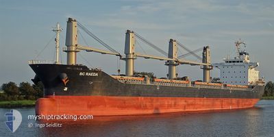
BC RAEDA
Bulk Carrier

Current Trip
ORDER
| Time Travelled | 34 days |
|---|---|
| Remaining Time | --- |
| Distance Travelled | 2723.77 nm |
| Remaining Distance | --- |
| AVG Speed | 9.7 Knop |
| MAX Speed | 16.8 Knop |
| AVG Wind | 10.6 knots |
| MAX Wind | 34 knots |
| MIN Temp | 2.1°C / 35.78°F |
| MAX Temp | 18°C / 64.4°F |
| Djupgående | 5.5 m |
| Position mottagen | 1 m sen |
Current Position
| Longitud | --- |
|---|---|
| Latitude | --- |
| Status | Under way using engine |
| Fart | 1.5 Knop |
| Kurs | 194° |
| Område | Mediterranean Sea - Eastern Basin |
| Station | T-AIS |
| Position mottagen | 1 m sen |
Information
The current position of BC RAEDA is in Mediterranean Sea - Eastern Basin with coordinates 33.56715° / 33.32143° as reported on 2025-03-08 11:22 by AIS to our vessel tracker app. The vessel's current speed is 1.5 Knop
The vessel BC RAEDA (IMO: 9487598, MMSI: 314572000) is a Bulk Carrier that was built in 2011 ( 14 År gammal ). It's sailing under the flag of [BB] Barbados.
In this page you can find informations about the vessels current position, last detected port calls, and current voyage information. If the vessels is not in coverage by AIS you will find the latest position.
The current position of BC RAEDA is detected by our AIS receivers and we are not responsible for the reliability of the data. The last position was recorded while the vessel was in Coverage by the Ais receivers of our vessel tracking app.
The current draught of BC RAEDA as reported by AIS is 5.5 meters
Weather
| Temperature | 17.4°C / 63.32°F |
|---|---|
| Wind Speed | 12 knots |
| Direction | 288° WNW |
| Pressure | 1012.7 hPa |
| Humidity | 75.4 % |
| Cloud Coverage | 2 % |


Featured Company
Last Port Calls
| Port | Arrival | Departure | Time In Port |
|---|---|---|---|
| 2025-01-26 12:12 | 2025-02-01 18:33 | 6 d | |
| 2025-01-10 05:20 | 2025-01-13 12:42 | 3 d |
Most Visited Ports (Last year)
| Port | Arrivals | |
|---|---|---|
| 4 | ||
| 2 | ||
| 2 | ||
| 1 | ||
| 1 | ||
| 1 |
Last Trips
| Origin | Departure | Destination | Arrival | Distance | |
|---|---|---|---|---|---|
| 2025-01-13 13:42 | 2025-01-26 13:12 | 1716.57 nm | |||
| 2024-12-31 20:03 | 2025-01-10 06:20 | 367.03 nm |
Events
| Tid | Event | Detaljer | Position / Dest | Information |
|---|---|---|---|---|
| 2025-03-08 06:35 | Status ändrad | Under way using engine Default |
33.69275 / 33.32323
ORDER
|
Fart: 1.9 kn Kurs: 209° |
| 2025-03-08 06:18 | Status ändrad | Default Under way using engine |
33.70267 / 33.32400
ORDER
|
Fart: 2 kn Kurs: 208° |
| 2025-03-08 06:03 | Status ändrad | Under way using engine Default |
33.71118 / 33.32435
ORDER
|
Fart: 2.1 kn Kurs: 207° |
| 2025-03-08 06:01 | Status ändrad | Default Under way using engine |
33.71218 / 33.32439
ORDER
|
Fart: 2.1 kn Kurs: 212° |
| 2025-03-07 19:19 | Status ändrad | Under way using engine Default |
34.08704 / 33.25757
ORDER
|
Fart: 0.9 kn Kurs: 239° |
| 2025-03-07 19:18 | Status ändrad | Default Under way using engine |
34.08733 / 33.25766
ORDER
|
Fart: 1 kn Kurs: 240° |
| 2025-03-07 19:07 | Status ändrad | Under way using engine Default |
34.09002 / 33.25852
ORDER
|
Fart: 0.9 kn Kurs: 257° |
| 2025-03-07 19:02 | I täckningsområde |
34.09002 / 33.25852
Mediterranean Sea - Eastern Basin
|
Fart: 0.9 kn Kurs: 200.5° |
|
| 2025-03-07 17:57 | Status ändrad | Default Under way using engine |
34.10301 / 33.27187
ORDER
|
Fart: 0.9 kn Kurs: 325° |
| 2025-03-07 17:49 | UTANFÖR täckningsområde |
34.10358 / 33.27428
Mediterranean Sea - Eastern Basin
|
Fart: 0.9 kn Kurs: 255.6° |