
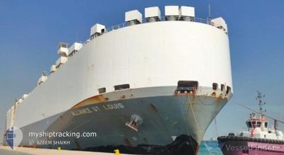
ALLIANCE ST.LOUIS
Vehicles Carrier
Current Trip
| Trip Time | 4 days |
|---|---|
| Trip Distance | 1520.04 nm |
| AVG Speed | 16 Knop |
| MAX Speed | 20.2 Knop |
| Djupgående | 7.8 m |
| AVG Wind | 8.1 knots |
| MAX Wind | 17 knots |
| MIN Temp | 25.2°C / 77.36°F |
| MAX Temp | 33°C / 91.4°F |
| Position mottagen | 3 d sen |
Current Position
| Longitud | 57.35948° |
|---|---|
| Latitude | 25.15602° |
| Status | Under way using engine |
| Fart | 17.2 Knop |
| Kurs | 121° |
| Område | Gulf of Oman |
| Station | T-AIS |
| Position mottagen | 3 d sen |
Info
Information
The current position of ALLIANCE ST.LOUIS is in Gulf of Oman with coordinates 25.15602° / 57.35948° as reported on 2024-04-27 02:22 by AIS to our vessel tracker app. The vessel's current speed is 17.2 Knop and is currently inside the port of PIPAVAV.
The vessel ALLIANCE ST.LOUIS (IMO: 9285500, MMSI: 367093000) is a Vehicles Carrier that was built in 2005 ( 19 År gammal ). It's sailing under the flag of [US] USA.
In this page you can find informations about the vessels current position, last detected port calls, and current voyage information. If the vessels is not in coverage by AIS you will find the latest position.
The current position of ALLIANCE ST.LOUIS is detected by our AIS receivers and we are not responsible for the reliability of the data. The last position was recorded while the vessel was in Coverage by the Ais receivers of our vessel tracking app.
The current draught of ALLIANCE ST.LOUIS as reported by AIS is 7.8 meters
Weather
| Temperature | 36.1°C / 96.98°F |
|---|---|
| Wind Speed | 11 knots |
| Direction | 341° NNW |
| Pressure | 1009.5 hPa |
| Humidity | 23.1 % |
| Cloud Coverage | 5 % |
Featured Company
Last Port Calls
| Port | Arrival | Departure | Time In Port |
|---|---|---|---|
| 2024-04-29 20:34 | |||
| 2024-04-24 16:58 | 2024-04-25 11:50 | 18 h | |
| 2024-04-23 17:12 | 2024-04-24 07:51 | 14 h | |
| 2024-04-22 10:29 | 2024-04-22 17:57 | 7 h | |
| 2024-04-19 01:44 | 2024-04-21 03:51 | 2 d | |
| 2024-03-04 01:15 | |||
| 2024-02-16 04:14 | 2024-02-17 02:28 | 22 h | |
| 2024-02-07 04:37 | 2024-02-07 13:52 | 9 h | |
| 2024-02-05 04:07 | |||
| 2024-02-01 10:08 | 2024-02-02 09:35 | 23 h |
Last Trips
| Origin | Departure | Destination | Arrival | Distance | |
|---|---|---|---|---|---|
| 2024-04-25 14:50 | 2024-04-30 02:04 | 1520.04 nm | |||
| 2024-04-24 10:51 | 2024-04-24 19:58 | 51.09 nm | |||
| 2024-04-22 20:57 | 2024-04-23 20:12 | 298.03 nm | |||
| 2024-04-21 07:51 | 2024-04-22 13:29 | 376.18 nm | |||
| 2024-02-17 03:28 | 2024-03-03 19:15 | 5029.68 nm | |||
| 2024-02-05 07:07 | 2024-02-16 05:14 | 3079.43 nm | |||
| 2024-02-05 07:07 | 2024-02-07 06:37 | 493.33 nm | |||
| 2024-01-30 20:06 | 2024-02-01 13:08 | 543.78 nm |
Events
| Tid | Event | Detaljer | Position / Dest | Information |
|---|---|---|---|---|
| 2024-04-29 20:34 | STOPPAR förflyttning |
20.91500 / 71.50667
[IN] PIPAVAV
|
Fart: Kurs: -1° |
|
| 2024-04-29 20:34 | ANLÄNDER HAMN |
|
20.91500 / 71.50667
[IN] PIPAVAV
|
Fart: 1 kn Kurs: -1° |
| 2024-04-29 19:21 | STARTAR förflyttning | 3.93 nm, South East of PIPAVAV |
20.86705 / 71.55285
INPAV
|
Fart: 7.9 kn Kurs: 273° |
| 2024-04-29 09:36 | STOPPAR förflyttning | 4.44 nm, South East of PIPAVAV |
20.86527 / 71.56360
INPAV
|
Fart: 0.1 kn Kurs: 231° |
| 2024-04-27 02:29 | Status ändrad | Default Under way using engine |
25.14228 / 57.39237
INPAV
|
Fart: 17.2 kn Kurs: 121° |
| 2024-04-27 02:22 | UTANFÖR täckningsområde |
25.15602 / 57.35948
Gulf of Oman
INPAV
|
Fart: 17.2 kn Kurs: 121° |
|
| 2024-04-26 23:59 | Byter havsområde | Iranian part of the Gulf of Oman Omani part of the Gulf of Oman |
25.68690 / 56.84525
Gulf of Oman
INPAV
|
Fart: 18 kn Kurs: 154° |
| 2024-04-26 23:11 | Byter havsområde | Omani part of the Gulf of Oman Omani part of the Persian Gulf |
25.90573 / 56.74633
Gulf of Oman
INPAV
|
Fart: 17.4 kn Kurs: 165° |
| 2024-04-26 23:09 | Status ändrad | Under way using engine Default |
25.91603 / 56.74302
INPAV
|
Fart: 17.3 kn Kurs: 162° |
| 2024-04-26 23:04 | I täckningsområde |
25.90573 / 56.74633
Gulf of Oman
INPAV
|
Fart: 17.4 kn Kurs: 165° |