
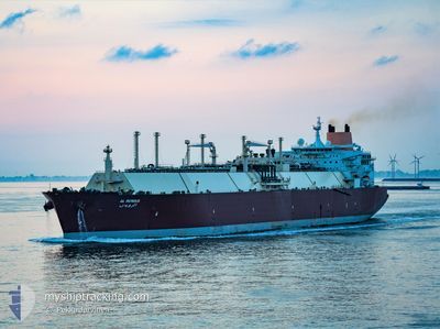
AL RUWAIS
Lng Tanker
Current Trip
| Time Travelled | 58 days |
|---|---|
| Remaining Time | 9 days |
| Distance Travelled | 9210.36 nm |
| Remaining Distance | 4046.71 nm |
| AVG Speed | 14.9 Knop |
| MAX Speed | 18.8 Knop |
| AVG Wind | 10.3 knots |
| MAX Wind | 33.2 knots |
| MIN Temp | 13.2°C / 55.76°F |
| MAX Temp | 29.3°C / 84.74°F |
| Djupgående | 9.6 m |
| Position mottagen | 8 d sen |
Current Position
| Longitud | -18.03169° |
|---|---|
| Latitude | 14.58746° |
| Status | Under way using engine |
| Fart | 17.2 Knop |
| Kurs | 171° |
| Område | North Atlantic Ocean |
| Station | T-AIS |
| Position mottagen | 8 d sen |
Info
Information
The current position of AL RUWAIS is in North Atlantic Ocean with coordinates 14.58746° / -18.03169° as reported on 2024-04-24 01:03 by AIS to our vessel tracker app. The vessel's current speed is 17.2 Knop and is heading at the port of LAS PALMAS. The estimated time of arrival as calculated by MyShipTracking vessel tracking app is 2024-05-12 10:22 LT
The vessel AL RUWAIS (IMO: 9337951, MMSI: 309904000) is a Lng Tanker that was built in 2007 ( 17 År gammal ). It's sailing under the flag of [BS] Bahamas.
In this page you can find informations about the vessels current position, last detected port calls, and current voyage information. If the vessels is not in coverage by AIS you will find the latest position.
The current position of AL RUWAIS is detected by our AIS receivers and we are not responsible for the reliability of the data. The last position was recorded while the vessel was in Coverage by the Ais receivers of our vessel tracking app.
The current draught of AL RUWAIS as reported by AIS is 9.6 meters
Weather
| Temperature | 18.3°C / 64.94°F |
|---|---|
| Wind Speed | 6 knots |
| Direction | 294° WNW |
| Pressure | 1014 hPa |
| Humidity | 87.7 % |
| Cloud Coverage | 4 % |
Featured Company
Last Port Calls
| Port | Arrival | Departure | Time In Port |
|---|---|---|---|
| 2024-03-04 03:56 | 2024-03-05 05:07 | 1 d |
Most Visited Ports (Last year)
| Port | Arrivals | |
|---|---|---|
| 10 | ||
| 4 | ||
| 2 | ||
| 1 | ||
| 1 |
Last Trips
| Origin | Departure | Destination | Arrival | Distance | |
|---|---|---|---|---|---|
| 2024-01-27 13:20 | 2024-03-04 06:56 | 11548.91 nm |
Events
| Tid | Event | Detaljer | Position / Dest | Information |
|---|---|---|---|---|
| 2024-04-24 01:10 | Status ändrad | Default Under way using engine |
14.55475 / -18.02634
LAS PALMAS OPL
|
Fart: 17.2 kn Kurs: 171° |
| 2024-04-24 01:03 | Upptäckt i hav | Senegalese part of the North Atlantic Ocean |
14.58746 / -18.03169
North Atlantic Ocean
LAS PALMAS OPL
|
Fart: 17.2 kn Kurs: 171° |
| 2024-04-24 01:03 | UTANFÖR täckningsområde |
14.58746 / -18.03169
North Atlantic Ocean
LAS PALMAS OPL
|
Fart: 17.2 kn Kurs: 171° |
|
| 2024-04-24 01:03 | I täckningsområde |
14.58746 / -18.03169
North Atlantic Ocean
LAS PALMAS OPL
|
Fart: 17.2 kn Kurs: 171° |
|
| 2024-04-24 01:02 | Status ändrad | Under way using engine Default |
14.59424 / -18.03280
LAS PALMAS OPL
|
Fart: 17.2 kn Kurs: 171° |