
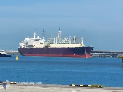
AL AREESH
Lng Tanker
Current Trip
| Trip Time | 20 days |
|---|---|
| Trip Distance | 6810.47 nm |
| AVG Speed | 15.2 Knop |
| MAX Speed | 20.3 Knop |
| Djupgående | 8.8 m |
| AVG Wind | 7.4 knots |
| MAX Wind | 17.6 knots |
| MIN Temp | 23.6°C / 74.48°F |
| MAX Temp | 30.4°C / 86.72°F |
| Position mottagen | 17 h, 29 m sen |
Current Position
| Longitud | 51.71273° |
|---|---|
| Latitude | 25.93442° |
| Status | Under way using engine |
| Fart | 10.3 Knop |
| Kurs | 236.9° |
| Område | Persian Gulf |
| Station | T-AIS |
| Position mottagen | 17 h, 29 m sen |
Info
Information
The current position of AL AREESH is in Persian Gulf with coordinates 25.93442° / 51.71273° as reported on 2024-04-27 20:47 by AIS to our vessel tracker app. The vessel's current speed is 10.3 Knop and is currently inside the port of RAS LAFFAN.
The vessel AL AREESH (IMO: 9325697, MMSI: 311038000) is a Lng Tanker that was built in 2007 ( 17 År gammal ). It's sailing under the flag of [BS] Bahamas.
In this page you can find informations about the vessels current position, last detected port calls, and current voyage information. If the vessels is not in coverage by AIS you will find the latest position.
The current position of AL AREESH is detected by our AIS receivers and we are not responsible for the reliability of the data. The last position was recorded while the vessel was in Coverage by the Ais receivers of our vessel tracking app.
The current draught of AL AREESH as reported by AIS is 8.8 meters
Weather
| Temperature | 28.4°C / 83.12°F |
|---|---|
| Wind Speed | 8 knots |
| Direction | 106° ESE |
| Pressure | 1009.6 hPa |
| Humidity | 53.6 % |
| Cloud Coverage | 100 % |
Featured Company
Last Port Calls
| Port | Arrival | Departure | Time In Port |
|---|---|---|---|
| 2024-04-27 21:07 | |||
| 2024-04-06 00:19 | 2024-04-06 22:18 | 21 h | |
| 2024-03-27 07:55 | 2024-03-28 14:51 | 1 d | |
| 2024-02-20 12:17 |
Most Visited Ports (Last year)
| Port | Arrivals | |
|---|---|---|
| 14 | ||
| 4 | ||
| 3 | ||
| 1 | ||
| 1 | ||
| 1 |
Last Trips
| Origin | Departure | Destination | Arrival | Distance | |
|---|---|---|---|---|---|
| 2024-04-07 01:18 | 2024-04-28 00:07 | 6810.47 nm | |||
| 2024-03-28 17:51 | 2024-04-06 03:19 | 2127.98 nm | |||
| 2024-02-20 15:17 | 2024-03-27 10:55 | 7734.82 nm |
Events
| Tid | Event | Detaljer | Position / Dest | Information |
|---|---|---|---|---|
| 2024-04-27 21:46 | STOPPAR förflyttning |
25.93227 / 51.61174
[QA] RAS LAFFAN
|
Fart: 0.3 kn Kurs: 112° |
|
| 2024-04-27 21:07 | ANLÄNDER HAMN |
|
25.92442 / 51.64745
[QA] RAS LAFFAN
|
Fart: 11.1 kn Kurs: 274° |
| 2024-04-27 20:47 | Status ändrad | Default Under way using engine |
25.93283 / 51.71017
QA RLF
|
Fart: 10.3 kn Kurs: 236.9° |
| 2024-04-27 20:47 | UTANFÖR täckningsområde |
25.93442 / 51.71273
Persian Gulf
[QA] RAS LAFFAN
|
Fart: 10.3 kn Kurs: 236.9° |
|
| 2024-04-27 19:11 | Status ändrad | Under way using engine Default |
26.03830 / 51.97633
QA RLF
|
Fart: 14.7 kn Kurs: 262° |
| 2024-04-27 19:00 | Status ändrad | Default Under way using engine |
26.04464 / 52.02812
QA RLF
|
Fart: 14.7 kn Kurs: 260.3° |
| 2024-04-27 16:47 | Byter havsområde | Qatari part of the Persian Gulf Iranian part of the Persian Gulf |
26.17349 / 52.63105
Persian Gulf
QA RLF
|
Fart: 15 kn Kurs: 256.5° |
| 2024-04-27 15:52 | Status ändrad | Under way using engine Default |
26.15529 / 52.87811
QA RLF
|
Fart: 15.1 kn Kurs: 276° |
| 2024-04-27 15:41 | I täckningsområde |
26.15550 / 52.87586
Persian Gulf
QA RLF
|
Fart: 15.1 kn Kurs: 275.9° |
|
| 2024-04-27 13:29 | UTANFÖR täckningsområde |
26.12422 / 53.54819
Persian Gulf
QA RLF
|
Fart: 15.6 kn Kurs: 273.3° |