
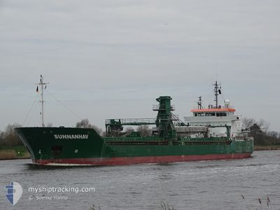
SUNNANHAV
General Cargo
Current Trip
| Time Travelled | 8 h, 16 mins |
|---|---|
| Remaining Time | --- |
| Distance Travelled | 81.11 морская миля |
| Remaining Distance | --- |
| AVG Speed | 9.4 Узлы |
| MAX Speed | 10.8 Узлы |
| AVG Wind | 13.4 knots |
| MAX Wind | 16.5 knots |
| MIN Temp | 20.4°C / 68.72°F |
| MAX Temp | 28.7°C / 83.66°F |
| Осадка | 7.4 м |
| Позиция Получена | 1 m тому назад |
Current Position
| Долгота | 13.70772° |
|---|---|
| Широта | 54.63607° |
| Статус | Under way using engine |
| Скорость | 10.2 Узлы |
| Курс | 330.9° |
| Район | Baltic Sea |
| Станция | T-AIS |
| Позиция Получена | 1 m тому назад |
Info
Information
The current position of SUNNANHAV is in Baltic Sea with coordinates 54.63607° / 13.70772° as reported on 2024-09-06 23:48 by AIS to our vessel tracker app. The vessel's current speed is 10.2 Узлы and is heading at the port of WARRENPOINT. The estimated time of arrival as calculated by MyShipTracking vessel tracking app is 2024-09-11 18:00 LT
The vessel SUNNANHAV (IMO: 9341160, MMSI: 231790000) is a General Cargo that was built in 2006 ( 18 лет ). It's sailing under the flag of [FO] Faroe Is.
In this page you can find informations about the vessels current position, last detected port calls, and current voyage information. If the vessels is not in coverage by AIS you will find the latest position.
The current position of SUNNANHAV is detected by our AIS receivers and we are not responsible for the reliability of the data. The last position was recorded while the vessel was in Coverage by the Ais receivers of our vessel tracking app.
The current draught of SUNNANHAV as reported by AIS is 7.4 meters
Weather
| Temperature | 20.4°C / 68.72°F |
|---|---|
| Wind Speed | 17 knots |
| Direction | 87° E |
| Pressure | 1017.4 hPa |
| Humidity | 82.8 % |
| Cloud Coverage | 11 % |
Featured Company
Last Port Calls
| Port | Arrival | Departure | Time In Port |
|---|---|---|---|
| 2024-09-03 14:45 | 2024-09-06 15:33 | 3 d | |
| 2024-09-01 19:12 | 2024-09-01 19:59 | 47 m | |
| 2024-08-24 21:25 | 2024-09-01 13:10 | 7 d | |
| 2024-08-24 12:53 | 2024-08-24 14:47 | 1 h | |
| 2024-08-18 06:53 | 2024-08-20 10:29 | 2 d | |
| 2024-08-16 07:58 | 2024-08-17 19:48 | 1 d | |
| 2024-08-13 04:03 | 2024-08-13 19:40 | 15 h | |
| 2024-08-09 14:03 | 2024-08-10 15:38 | 1 d | |
| 2024-08-05 05:38 | 2024-08-06 10:14 | 1 d | |
| 2024-08-01 18:23 | 2024-08-01 19:04 | 41 m |
Last Trips
| Origin | Departure | Destination | Arrival | Distance | |
|---|---|---|---|---|---|
| 2024-09-01 21:59 | 2024-09-03 16:45 | 396.78 морская миля | |||
| 2024-09-01 15:10 | 2024-09-01 21:12 | 66.48 морская миля | |||
| 2024-08-24 16:47 | 2024-08-24 23:25 | 66.10 морская миля | |||
| 2024-08-20 12:29 | 2024-08-24 14:53 | 1062.28 морская миля | |||
| 2024-08-17 20:48 | 2024-08-18 08:53 | 87.88 морская миля | |||
| 2024-08-13 21:40 | 2024-08-16 08:58 | 596.32 морская миля | |||
| 2024-08-10 16:38 | 2024-08-13 06:03 | 657.98 морская миля | |||
| 2024-08-06 12:14 | 2024-08-09 15:03 | 665.49 морская миля | |||
| 2024-08-01 21:04 | 2024-08-05 07:38 | 891.87 морская миля | |||
| 2024-08-01 14:32 | 2024-08-01 20:23 | 65.96 морская миля |
Events
| Время | Событие | Детали | Позиция / Направление | Информация |
|---|---|---|---|---|
| 2024-09-06 20:17 | Изменение морского района | German part of the Baltic Sea Polish part of the Baltic Sea |
54.13061 / 14.22785
Baltic Sea
PL SZZ => GB WPT
|
Скорость: 10.3 kn Курс: 350.7° |
| 2024-09-06 17:03 | Статус изменился | Under way using engine Default |
53.67101 / 14.52311
PL SZZ => GB WPT
|
Скорость: 9.2 kn Курс: 322° |
| 2024-09-06 17:01 | Статус изменился | Default Under way using engine |
53.66624 / 14.52941
PL SZZ => GB WPT
|
Скорость: 9.2 kn Курс: 319.8° |
| 2024-09-06 16:59 | Статус изменился | Under way using engine Default |
53.66226 / 14.53482
PL SZZ => GB WPT
|
Скорость: 9.4 kn Курс: 320° |
| 2024-09-06 16:57 | Статус изменился | Default Under way using engine |
53.65856 / 14.53974
PL SZZ => GB WPT
|
Скорость: 9.4 kn Курс: 319.9° |
| 2024-09-06 16:26 | Статус изменился | Under way using engine Default |
53.58708 / 14.59481
PL SZZ => GB WPT
|
Скорость: 8.5 kn Курс: 356° |
| 2024-09-06 15:49 | Статус изменился | Default Under way using engine |
53.50766 / 14.62964
PL SZZ => GB WPT
|
Скорость: 8 kn Курс: 16.8° |
| 2024-09-06 15:48 | Статус изменился | Under way using engine Default |
53.50625 / 14.62888
PL SZZ => GB WPT
|
Скорость: 8 kn Курс: 17° |
| 2024-09-06 15:33 | Статус изменился | Default Under way using engine |
53.47505 / 14.60866
PL SZZ => GB WPT
|
Скорость: 7.6 kn Курс: 17° |
| 2024-09-06 15:33 | ПОРТ ОТПРАВЛЕНИЯ |
|
53.47505 / 14.60866
PL SZZ => GB WPT
|
Скорость: 7.6 kn Курс: 17° |