
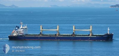
SOLDOY
Bulk Carrier
Current Trip
| Time Travelled | 44 days |
|---|---|
| Remaining Time | --- |
| Distance Travelled | 6755.31 морская миля |
| Remaining Distance | --- |
| AVG Speed | 10.3 Узлы |
| MAX Speed | 14.3 Узлы |
| AVG Wind | 6 knots |
| MAX Wind | 18.5 knots |
| MIN Temp | 19.6°C / 67.28°F |
| MAX Temp | 31.4°C / 88.52°F |
| Осадка | 13.3 м |
| Позиция Получена | 6 d тому назад |
Current Position
| Долгота | 128.40852° |
|---|---|
| Широта | 0.27754° |
| Статус | Under way using engine |
| Скорость | 11.8 Узлы |
| Курс | 109.3° |
| Район | Halamahera Sea |
| Станция | T-AIS |
| Позиция Получена | 6 d тому назад |
Info
Information
The current position of SOLDOY is in Halamahera Sea with coordinates 0.27754° / 128.40852° as reported on 2024-04-20 06:11 by AIS to our vessel tracker app. The vessel's current speed is 11.8 Узлы and is heading at the port of WEDA.
The vessel SOLDOY (IMO: 9618111, MMSI: 566211000) is a Bulk Carrier that was built in 2011 ( 13 лет ). It's sailing under the flag of [SG] Singapore.
In this page you can find informations about the vessels current position, last detected port calls, and current voyage information. If the vessels is not in coverage by AIS you will find the latest position.
The current position of SOLDOY is detected by our AIS receivers and we are not responsible for the reliability of the data. The last position was recorded while the vessel was in Coverage by the Ais receivers of our vessel tracking app.
The current draught of SOLDOY as reported by AIS is 13.3 meters
Weather
| Temperature | 29.6°C / 85.28°F |
|---|---|
| Wind Speed | 9 knots |
| Direction | 58° ENE |
| Pressure | 1005.5 hPa |
| Humidity | 72.3 % |
| Cloud Coverage | 100 % |
Featured Company
Events
| Время | Событие | Детали | Позиция / Направление | Информация |
|---|---|---|---|---|
| 2024-04-23 09:21 | Окончание движения |
-.23833 / 117.54667
ID WED
|
Скорость: Курс: -1° |
|
| 2024-04-20 06:27 | Статус изменился | Default Under way using engine |
.25833 / 128.45833
ID WED
|
Скорость: 11.8 kn Курс: 109.3° |
| 2024-04-20 06:11 | Вне покрытия |
.27754 / 128.40852
Halamahera Sea
|
Скорость: 11.8 kn Курс: 109.3° |
|
| 2024-04-20 03:38 | Начало движения | 10.01 nm, North East of WEDA |
.46881 / 127.97213
ID WED
|
Скорость: 3.1 kn Курс: 125° |
| 2024-04-20 03:27 | Статус изменился | Under way using engine Moored |
.47520 / 127.96753
ID WED
|
Скорость: 0.7 kn Курс: 176° |
| 2024-04-20 01:52 | Статус изменился | Moored Default |
.47618 / 127.96658
ID WED
|
Скорость: Курс: -1° |
| 2024-04-20 01:48 | Статус изменился | Default Moored |
.47500 / 127.96500
ID WED
|
Скорость: Курс: 221° |
| 2024-04-19 23:16 | Статус изменился | Moored Default |
.47608 / 127.96660
ID WED
|
Скорость: Курс: -1° |
| 2024-04-19 23:12 | Статус изменился | Default Moored |
.47500 / 127.96500
ID WED
|
Скорость: Курс: 221° |
| 2024-04-19 16:22 | Статус изменился | Moored Default |
.47609 / 127.96659
ID WED
|
Скорость: Курс: -1° |