
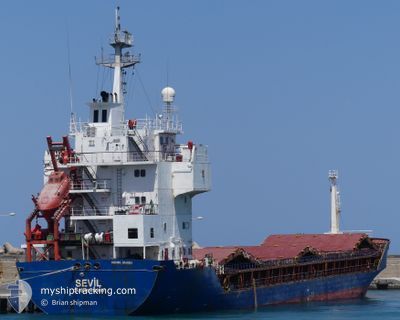
SEVIL
General Cargo
Current Trip
| Time Travelled | 11 days |
|---|---|
| Remaining Time | --- |
| Distance Travelled | 621.99 морская миля |
| Remaining Distance | --- |
| AVG Speed | 8.1 Узлы |
| MAX Speed | 19 Узлы |
| AVG Wind | 10.7 knots |
| MAX Wind | 31.3 knots |
| MIN Temp | 11.1°C / 51.98°F |
| MAX Temp | 18.3°C / 64.94°F |
| Осадка | 4.4 м |
| Позиция Получена | 8 d тому назад |
Current Position
| Долгота | 29.24896° |
|---|---|
| Широта | 41.49781° |
| Статус | Under way using engine |
| Скорость | 10.4 Узлы |
| Курс | 8.5° |
| Район | Black Sea |
| Станция | T-AIS |
| Позиция Получена | 8 d тому назад |
Info
Information
The current position of SEVIL is in Black Sea with coordinates 41.49781° / 29.24896° as reported on 2024-04-22 20:13 by AIS to our vessel tracker app. The vessel's current speed is 10.4 Узлы
The vessel SEVIL (IMO: 9148518, MMSI: 577528000) is a General Cargo that was built in 1997 ( 27 лет ). It's sailing under the flag of [VU] Vanuatu.
In this page you can find informations about the vessels current position, last detected port calls, and current voyage information. If the vessels is not in coverage by AIS you will find the latest position.
The current position of SEVIL is detected by our AIS receivers and we are not responsible for the reliability of the data. The last position was recorded while the vessel was in Coverage by the Ais receivers of our vessel tracking app.
The current draught of SEVIL as reported by AIS is 4.4 meters
Weather
| Temperature | 13.8°C / 56.84°F |
|---|---|
| Wind Speed | 11 knots |
| Direction | 28° NNE |
| Pressure | 1020.2 hPa |
| Humidity | 73.1 % |
| Cloud Coverage | 100 % |
Featured Company
Last Port Calls
| Port | Arrival | Departure | Time In Port |
|---|---|---|---|
| 2024-04-18 18:37 | 2024-04-20 12:55 | 1 d | |
| 2024-04-12 17:34 | 2024-04-14 05:16 | 1 d | |
| 2024-04-10 15:04 | 2024-04-12 17:29 | 2 d | |
| 2024-04-01 11:46 | 2024-04-02 23:16 | 1 d | |
| 2024-03-18 17:05 | 2024-03-22 09:47 | 3 d | |
| 2024-03-04 18:06 | 2024-03-11 17:59 | 6 d |
Last Trips
| Origin | Departure | Destination | Arrival | Distance | |
|---|---|---|---|---|---|
| 2024-04-14 08:16 | 2024-04-18 21:37 | 885.07 морская миля | |||
| 2024-04-12 20:29 | 2024-04-12 20:34 | 4.00 морская миля | |||
| 2024-04-03 02:16 | 2024-04-10 18:04 | 480.91 морская миля | |||
| 2024-03-22 11:47 | 2024-04-01 14:46 | 375.82 морская миля | |||
| 2024-03-11 20:59 | 2024-03-18 19:05 | 694.69 морская миля | |||
| 2024-02-29 07:51 | 2024-03-04 21:06 | 689.34 морская миля |
Events
| Время | Событие | Детали | Позиция / Направление | Информация |
|---|---|---|---|---|
| 2024-04-27 21:47 | Пункт назначения изменился | ROSUL BGBOJ |
45.15199 / 29.94188
ROSUL
|
Скорость: 0.1 kn Курс: 320° |
| 2024-04-27 21:47 | ETA изменился | 2024/04/23 20:30 2024/04/23 12:00 |
45.15199 / 29.94188
ROSUL
|
Скорость: 0.1 kn Курс: 320° |
| 2024-04-24 10:41 | Окончание движения | 12.39 nm, East of SULINA |
45.15420 / 29.93970
BGBOJ
|
Скорость: 0.3 kn Курс: 153° |
| 2024-04-24 02:14 | Начало движения | 10.61 nm, East of SULINA |
45.16646 / 29.89734
BGBOJ
|
Скорость: 3.1 kn Курс: 166° |
| 2024-04-23 20:22 | Окончание движения | 11.41 nm, East of SULINA |
45.15729 / 29.91668
BGBOJ
|
Скорость: Курс: 107° |
| 2024-04-22 20:22 | Статус изменился | Default Under way using engine |
41.52202 / 29.25347
BGBOJ
|
Скорость: 10.4 kn Курс: 8.5° |
| 2024-04-22 20:13 | Вне покрытия |
41.49781 / 29.24896
Black Sea
BGBOJ
|
Скорость: 10.4 kn Курс: 8.5° |
|
| 2024-04-22 20:01 | Статус изменился | Under way using engine At anchor |
41.46340 / 29.24302
BGBOJ
|
Скорость: 10.3 kn Курс: 6.8° |
| 2024-04-22 18:32 | Изменение морского района | Turkish part of the Black Sea Turkish part of the Sea of Marmara |
41.23436 / 29.14375
Black Sea
BGBOJ
|
Скорость: 9.8 kn Курс: 31.4° |
| 2024-04-22 15:05 | Начало движения | 1.11 nm, South of BAKIRKOY |
40.95500 / 28.88284
BGBOJ
|
Скорость: 4.4 kn Курс: 140° |