
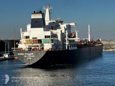
SEABULK CHALLENGE
Oil/Chemical Tanker
Current Trip
| Time Travelled | 22 h, 4 mins |
|---|---|
| Remaining Time | --- |
| Distance Travelled | 295.52 морская миля |
| Remaining Distance | 354.08 морская миля |
| AVG Speed | 15.5 Узлы |
| MAX Speed | 18.7 Узлы |
| AVG Wind | 14.6 knots |
| MAX Wind | 21 knots |
| MIN Temp | 9.5°C / 49.1°F |
| MAX Temp | 18.1°C / 64.58°F |
| Осадка | 10.8 м |
| Позиция Получена | 12 h, 58 m тому назад |
Current Position
| Долгота | --- |
|---|---|
| Широта | --- |
| Статус | Under way using engine |
| Скорость | 16.8 Узлы |
| Курс | 134.5° |
| Район | Gulf of Mexico |
| Станция | T-AIS |
| Позиция Получена | 12 h, 58 m тому назад |
Info
Information
The current position of SEABULK CHALLENGE is in Gulf of Mexico with coordinates 29.74994° / -90.02090° as reported on 2025-03-10 12:40 by AIS to our vessel tracker app. The vessel's current speed is 16.8 Узлы and is heading at the port of TAMPA. The estimated time of arrival as calculated by MyShipTracking vessel tracking app is 2025-03-11 12:00 LT
The vessel SEABULK CHALLENGE (IMO: 7816551, MMSI: 303104000) is a Oil/Chemical Tanker that was built in 1981 ( 44 лет ). It's sailing under the flag of [US] USA.
In this page you can find informations about the vessels current position, last detected port calls, and current voyage information. If the vessels is not in coverage by AIS you will find the latest position.
The current position of SEABULK CHALLENGE is detected by our AIS receivers and we are not responsible for the reliability of the data. The last position was recorded while the vessel was in Coverage by the Ais receivers of our vessel tracking app.
The current draught of SEABULK CHALLENGE as reported by AIS is 10.8 meters
Weather
| Temperature | 18.7°C / 65.66°F |
|---|---|
| Wind Speed | 15 knots |
| Direction | 347° NNW |
| Pressure | 1016.8 hPa |
| Humidity | 67.6 % |
| Cloud Coverage | 100 % |
Featured Company
Last Port Calls
| Port | Arrival | Departure | Time In Port |
|---|---|---|---|
| 2025-03-07 19:55 | 2025-03-10 03:35 | 2 d | |
| 2025-03-06 04:19 | 2025-03-07 08:53 | 1 d | |
| 2025-03-02 02:10 | 2025-03-04 17:27 | 2 d | |
| 2025-02-24 04:18 | 2025-02-26 12:49 | 2 d | |
| 2025-02-19 16:05 | 2025-02-22 00:53 | 2 d | |
| 2025-02-14 18:26 | 2025-02-17 10:00 | 2 d | |
| 2025-02-06 04:31 | 2025-02-08 18:00 | 2 d | |
| 2025-02-01 09:33 | 2025-02-03 19:08 | 2 d | |
| 2025-01-26 04:55 | 2025-01-28 18:54 | 2 d | |
| 2025-01-20 13:26 | 2025-01-24 09:31 | 3 d |
Most Visited Ports (Last year)
| Port | Arrivals | |
|---|---|---|
| 10 | ||
| 9 | ||
| 9 | ||
| 5 | ||
| 5 | ||
| 4 |
Last Trips
| Origin | Departure | Destination | Arrival | Distance | |
|---|---|---|---|---|---|
| 2025-03-07 02:53 | 2025-03-07 13:55 | 95.25 морская миля | |||
| 2025-03-04 12:27 | 2025-03-05 22:19 | 473.79 морская миля | |||
| 2025-02-26 06:49 | 2025-03-01 21:10 | 731.04 морская миля | |||
| 2025-02-21 19:53 | 2025-02-23 22:18 | 727.77 морская миля | |||
| 2025-02-17 04:00 | 2025-02-19 11:05 | 711.43 морская миля | |||
| 2025-02-08 13:00 | 2025-02-14 12:26 | 733.71 морская миля | |||
| 2025-02-03 13:08 | 2025-02-05 23:31 | 724.35 морская миля | |||
| 2025-01-28 13:54 | 2025-02-01 03:33 | 737.17 морская миля | |||
| 2025-01-24 03:31 | 2025-01-25 23:55 | 618.07 морская миля | |||
| 2025-01-18 21:25 | 2025-01-20 07:26 | 95.92 морская миля |
Events
| Время | Событие | Детали | Позиция / Направление | Информация |
|---|---|---|---|---|
| 2025-03-10 12:48 | Статус изменился | Default Under way using engine |
29.72757 / -89.99040
TAMPA
|
Скорость: 16.8 kn Курс: 134.5° |
| 2025-03-10 12:40 | Вне покрытия |
29.74994 / -90.02090
Gulf of Mexico
TAMPA
|
Скорость: 16.8 kn Курс: 134.5° |
|
| 2025-03-10 11:08 | Пункт назначения изменился | TAMPA BATON ROUGE |
29.93167 / -90.05899
TAMPA
|
Скорость: 16.3 kn Курс: 20.2° |
| 2025-03-10 11:08 | ETA изменился | 2025/03/11 12:00 2025/03/07 12:00 |
29.93167 / -90.05899
TAMPA
|
Скорость: 16.3 kn Курс: 20.2° |
| 2025-03-10 10:32 | В покрытии |
29.94078 / -90.17076
Gulf of Mexico
|
Скорость: 16.2 kn Курс: 46.2° |
|
| 2025-03-10 10:31 | Статус изменился | Under way using engine Default |
29.93326 / -90.18059
BATON ROUGE
|
Скорость: 14.6 kn Курс: 70° |
| 2025-03-10 03:36 | Начало движения | 0.72 nm, North of BATON ROUGE |
30.46967 / -91.19773
BATON ROUGE
|
Скорость: 9.5 kn Курс: 194° |
| 2025-03-10 03:35 | ПОРТ ОТПРАВЛЕНИЯ |
|
30.46967 / -91.19773
BATON ROUGE
|
Скорость: 3.8 kn Курс: 228° |
| 2025-03-07 20:24 | Окончание движения |
30.47784 / -91.19434
[US] BATON ROUGE
|
Скорость: 0.1 kn Курс: 4° |
|
| 2025-03-07 19:55 | Порт |
|
30.47219 / -91.19591
[US] BATON ROUGE
|
Скорость: 3.3 kn Курс: 359° |