

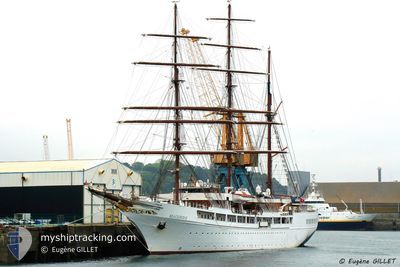
SEA CLOUD II
Passengers Ship

Current Trip
VG SPANISH TOWN
| Time Travelled | 2 days |
|---|---|
| Remaining Time | --- |
| Distance Travelled | 311.85 морская миля |
| Remaining Distance | --- |
| AVG Speed | 6.7 Узлы |
| MAX Speed | 13 Узлы |
| AVG Wind | 18.3 knots |
| MAX Wind | 21.5 knots |
| MIN Temp | 25.5°C / 77.9°F |
| MAX Temp | 26.9°C / 80.42°F |
| Осадка | 5.9 м |
| Позиция Получена | 21 m тому назад |
Current Position
| Долгота | --- |
|---|---|
| Широта | --- |
| Статус | At anchor |
| Скорость | 0.1 Узлы |
| Курс | 112° |
| Район | Caribbean Sea |
| Станция | T-AIS |
| Позиция Получена | 21 m тому назад |
Information
The current position of SEA CLOUD II is in Caribbean Sea with coordinates 17.89568° / -62.86289° as reported on 2025-03-27 17:54 by AIS to our vessel tracker app. The vessel's current speed is 0.1 Узлы
The vessel SEA CLOUD II (IMO: 9171292, MMSI: 248953000) is a Passengers Ship that was built in 2000 ( 25 лет ). It's sailing under the flag of [MT] Malta.
In this page you can find informations about the vessels current position, last detected port calls, and current voyage information. If the vessels is not in coverage by AIS you will find the latest position.
The current position of SEA CLOUD II is detected by our AIS receivers and we are not responsible for the reliability of the data. The last position was recorded while the vessel was in Coverage by the Ais receivers of our vessel tracking app.
The current draught of SEA CLOUD II as reported by AIS is 5.9 meters
Weather
| Temperature | 26.5°C / 79.7°F |
|---|---|
| Wind Speed | 16 knots |
| Direction | 114° ESE |
| Pressure | 1016.4 hPa |
| Humidity | 74.3 % |
| Cloud Coverage | 39 % |


Featured Company
Last Port Calls
| Port | Arrival | Departure | Time In Port |
|---|---|---|---|
| 2025-03-24 05:56 | 2025-03-24 19:03 | 13 h | |
| 2025-03-17 06:39 | 2025-03-17 19:03 | 12 h | |
| 2025-03-07 06:44 | 2025-03-07 20:11 | 13 h | |
| 2025-02-25 06:47 | 2025-02-25 19:12 | 12 h | |
| 2025-02-18 07:15 | 2025-02-18 22:08 | 14 h | |
| 2025-02-11 12:51 | 2025-02-11 18:06 | 5 h | |
| 2025-02-06 02:23 | 2025-02-07 13:55 | 1 d | |
| 2025-01-26 07:01 | 2025-01-26 21:56 | 14 h | |
| 2025-01-14 07:41 | 2025-01-14 21:38 | 13 h | |
| 2025-01-08 07:51 | 2025-01-08 19:13 | 11 h |
Most Visited Ports (Last year)
| Port | Arrivals | |
|---|---|---|
| 7 | ||
| 7 | ||
| 5 | ||
| 5 | ||
| 5 | ||
| 4 |
Last Trips
| Origin | Departure | Destination | Arrival | Distance | |
|---|---|---|---|---|---|
| 2025-03-17 19:03 | 2025-03-24 05:56 | 814.99 морская миля | |||
| 2025-03-07 20:11 | 2025-03-17 06:39 | 887.48 морская миля | |||
| 2025-02-25 19:12 | 2025-03-07 06:44 | 982.52 морская миля | |||
| 2025-02-18 22:08 | 2025-02-25 06:47 | 603.39 морская миля | |||
| 2025-02-11 18:06 | 2025-02-18 07:15 | 541.90 морская миля | |||
| 2025-02-07 13:55 | 2025-02-11 12:51 | 365.05 морская миля | |||
| 2025-01-26 21:56 | 2025-02-06 02:23 | 818.98 морская миля | |||
| 2025-01-14 21:38 | 2025-01-26 07:01 | 905.21 морская миля | |||
| 2025-01-08 19:13 | 2025-01-14 07:41 | 463.24 морская миля | |||
| 2025-01-03 21:29 | 2025-01-08 07:51 | 410.14 морская миля |
Events
| Время | Событие | Детали | Позиция / Направление | Информация |
|---|---|---|---|---|
| 2025-03-27 18:00 | Статус изменился | Default At anchor |
17.89567 / -62.86302
VG SPANISH TOWN
|
Скорость: 0.1 kn Курс: 112° |
| 2025-03-27 16:57 | Окончание движения | 0.66 nm, South West of GUSTAVIA |
17.89491 / -62.86359
VG SPANISH TOWN
|
Скорость: 0.1 kn Курс: 102° |
| 2025-03-27 16:53 | Статус изменился | At anchor Under way using engine |
17.89513 / -62.86290
VG SPANISH TOWN
|
Скорость: 0.4 kn Курс: 101° |
| 2025-03-27 15:41 | Статус изменился | Under way using engine Under way sailing |
17.81991 / -62.84790
VG SPANISH TOWN
|
Скорость: 4 kn Курс: 42° |
| 2025-03-27 14:56 | Статус изменился | Under way sailing Default |
17.76340 / -62.83834
VG SPANISH TOWN
|
Скорость: 5.7 kn Курс: 337° |
| 2025-03-27 14:48 | Статус изменился | Default Under way sailing |
17.75110 / -62.83322
VG SPANISH TOWN
|
Скорость: 5.7 kn Курс: 336.8° |
| 2025-03-27 14:35 | Обнаружено в море | Saint-Martin part of the Caribbean Sea |
17.73178 / -62.82526
Caribbean Sea
|
Скорость: 5.5 kn Курс: 336.1° |
| 2025-03-27 14:35 | Статус изменился | Under way sailing Default |
17.73178 / -62.82526
VG SPANISH TOWN
|
Скорость: 6.2 kn Курс: 335° |
| 2025-03-27 14:23 | В покрытии |
17.73178 / -62.82526
Caribbean Sea
|
Скорость: 5.5 kn Курс: 336.1° |
|
| 2025-03-27 09:09 | Вне покрытия |
17.68255 / -63.20194
Caribbean Sea
|
Скорость: 9.4 kn Курс: 108.1° |