
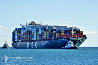
MSC GIULIA
Cargo D
Current Trip
| Trip Time | 1 day |
|---|---|
| Trip Distance | 165.75 морская миля |
| AVG Speed | 13.9 Узлы |
| MAX Speed | 13.9 Узлы |
| Осадка | 10.5 м |
| AVG Wind | 7.9 knots |
| MAX Wind | 16 knots |
| MIN Temp | 4.5°C / 40.1°F |
| MAX Temp | 9.9°C / 49.82°F |
| Позиция Получена | 1 m тому назад |
Current Position
| Долгота | --- |
|---|---|
| Широта | --- |
| Статус | Moored |
| Скорость | |
| Курс | 109° |
| Район | The Coastal Waters of Southeast Alaska and British Columbia |
| Станция | T-AIS |
| Позиция Получена | 1 m тому назад |
Info
Information
The current position of MSC GIULIA is in The Coastal Waters of Southeast Alaska and British Columbia with coordinates 49.28940° / -123.07554° as reported on 2025-03-17 22:41 by AIS to our vessel tracker app. The vessel's current speed is 0 Узлы and is currently inside the port of VANCOUVER.
The vessel MSC GIULIA (IMO: 9770737, MMSI: 255805869) is a Cargo D It's sailing under the flag of [PT] Portugal.
In this page you can find informations about the vessels current position, last detected port calls, and current voyage information. If the vessels is not in coverage by AIS you will find the latest position.
The current position of MSC GIULIA is detected by our AIS receivers and we are not responsible for the reliability of the data. The last position was recorded while the vessel was in Coverage by the Ais receivers of our vessel tracking app.
The current draught of MSC GIULIA as reported by AIS is 10.5 meters
Weather
| Temperature | 7.7°C / 45.86°F |
|---|---|
| Wind Speed | 6 knots |
| Direction | 262° W |
| Pressure | 1013.7 hPa |
| Humidity | 62 % |
| Cloud Coverage | 39 % |
Featured Company
Last Port Calls
| Port | Arrival | Departure | Time In Port |
|---|---|---|---|
| 2025-03-16 12:41 | |||
| 2025-03-13 05:44 | 2025-03-14 17:42 | 1 d | |
| 2025-03-08 14:35 | 2025-03-10 19:17 | 2 d | |
| 2025-03-04 05:22 | 2025-03-05 19:19 | 1 d | |
| 2025-02-28 13:12 | 2025-03-01 01:43 | 12 h | |
| 2025-02-21 12:23 | 2025-02-23 10:22 | 1 d | |
| 2025-02-06 08:01 | 2025-02-07 13:27 | 1 d | |
| 2025-02-03 12:21 | 2025-02-04 17:17 | 1 d | |
| 2025-01-29 23:40 | 2025-02-01 01:38 | 2 d | |
| 2025-01-26 11:19 | 2025-01-27 08:38 | 21 h |
Most Visited Ports (Last year)
| Port | Arrivals | |
|---|---|---|
| 7 | ||
| 7 | ||
| 7 | ||
| 4 | ||
| 4 | ||
| 4 |
Last Trips
| Origin | Departure | Destination | Arrival | Distance | |
|---|---|---|---|---|---|
| 2025-03-14 17:42 | 2025-03-16 12:41 | 165.75 морская миля | |||
| 2025-03-10 19:17 | 2025-03-13 05:44 | 1013.79 морская миля | |||
| 2025-03-05 19:19 | 2025-03-08 14:35 | 443.93 морская миля | |||
| 2025-03-01 01:43 | 2025-03-04 05:22 | 1231.40 морская миля | |||
| 2025-02-23 10:22 | 2025-02-28 13:12 | 1755.91 морская миля | |||
| 2025-02-07 13:27 | 2025-02-21 12:23 | 4581.67 морская миля | |||
| 2025-02-04 17:17 | 2025-02-06 08:01 | 687.05 морская миля | |||
| 2025-02-01 01:38 | 2025-02-03 12:21 | 551.94 морская миля | |||
| 2025-01-27 08:38 | 2025-01-29 23:40 | 298.15 морская миля | |||
| 2025-01-25 14:33 | 2025-01-26 11:19 | 308.57 морская миля |
Events
| Время | Событие | Детали | Позиция / Направление | Информация |
|---|---|---|---|---|
| 2025-03-16 20:32 | Статус изменился | Moored Under way using engine |
49.28943 / -123.07548
[CA] VANCOUVER
|
Скорость: 0.1 kn Курс: 108° |
| 2025-03-16 20:28 | Окончание движения |
49.28950 / -123.07555
[CA] VANCOUVER
|
Скорость: 0.3 kn Курс: 107° |
|
| 2025-03-16 19:41 | Порт |
|
49.31662 / -123.14609
[CA] VANCOUVER
|
Скорость: 9.3 kn Курс: 98.2° |
| 2025-03-16 18:13 | Изменение морского района | Canadian part of the The Coastal Waters of Southeast Alaska and British Columbia United States part of the The Coastal Waters of Southeast Alaska and British Columbia |
49.01086 / -123.25402
The Coastal Waters of Southeast Alaska and British Columbia
|
Скорость: 18.2 kn Курс: 316.4° |
| 2025-03-16 17:13 | Изменение морского района | United States part of the The Coastal Waters of Southeast Alaska and British Columbia Canadian part of the The Coastal Waters of Southeast Alaska and British Columbia |
48.79272 / -123.00397
The Coastal Waters of Southeast Alaska and British Columbia
|
Скорость: 18.2 kn Курс: 49.3° |
| 2025-03-16 16:55 | Изменение морского района | Canadian part of the The Coastal Waters of Southeast Alaska and British Columbia United States part of the The Coastal Waters of Southeast Alaska and British Columbia |
48.73870 / -123.10734
The Coastal Waters of Southeast Alaska and British Columbia
|
Скорость: 17.5 kn Курс: 62.8° |
| 2025-03-16 15:46 | Изменение морского района | United States part of the The Coastal Waters of Southeast Alaska and British Columbia Canadian part of the The Coastal Waters of Southeast Alaska and British Columbia |
48.46579 / -123.16380
The Coastal Waters of Southeast Alaska and British Columbia
|
Скорость: 17.1 kn Курс: 354.9° |
| 2025-03-16 14:13 | Начало движения | 4.46 nm, South of VICTORIA |
48.34989 / -123.36361
CAVAN
|
Скорость: 3.2 kn Курс: 240° |
| 2025-03-16 14:07 | Статус изменился | Under way using engine At anchor |
48.35077 / -123.36117
CAVAN
|
Скорость: 0.3 kn Курс: 244° |
| 2025-03-15 19:42 | ETA изменился | 2025/03/16 01:00 2025/03/16 15:00 |
48.35176 / -123.36470
CAVAN
|
Скорость: Курс: 171° |