
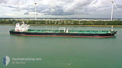
MONTREAL SPIRIT
Tanker C
Current Trip
| Time Travelled | --- |
|---|---|
| Remaining Time | 1 h, 9 mins |
| Distance Travelled | 12426.81 морская миля |
| Remaining Distance | 16.62 морская миля |
| AVG Speed | 12 Узлы |
| MAX Speed | 16.1 Узлы |
| AVG Wind | 11.6 knots |
| MAX Wind | 35 knots |
| MIN Temp | 12.4°C / 54.32°F |
| MAX Temp | 29.4°C / 84.92°F |
| Осадка | 10.1 м |
| Позиция Получена | 1 d тому назад |
Current Position
| Долгота | --- |
|---|---|
| Широта | --- |
| Статус | Under way using engine |
| Скорость | 0.7 Узлы |
| Курс | 98° |
| Район | Gulf of Thailand |
| Станция | T-AIS |
| Позиция Получена | 1 d тому назад |
Info
Information
The current position of MONTREAL SPIRIT is in Gulf of Thailand with coordinates 13.11605° / 100.72371° as reported on 2025-02-15 19:11 by AIS to our vessel tracker app. The vessel's current speed is 0.7 Узлы and is heading at the port of SIRACHA. The estimated time of arrival as calculated by MyShipTracking vessel tracking app is 2025-02-17 21:11 LT
The vessel MONTREAL SPIRIT (IMO: 9296389, MMSI: 311000454) is a Tanker C It's sailing under the flag of [BS] Bahamas.
In this page you can find informations about the vessels current position, last detected port calls, and current voyage information. If the vessels is not in coverage by AIS you will find the latest position.
The current position of MONTREAL SPIRIT is detected by our AIS receivers and we are not responsible for the reliability of the data. The last position was recorded while the vessel was in Coverage by the Ais receivers of our vessel tracking app.
The current draught of MONTREAL SPIRIT as reported by AIS is 10.1 meters
Weather
| Temperature | 27.4°C / 81.32°F |
|---|---|
| Wind Speed | 12 knots |
| Direction | 157° SSE |
| Pressure | 1011.3 hPa |
| Humidity | 80.7 % |
| Cloud Coverage | --- |
Featured Company
Last Port Calls
Most Visited Ports (Last year)
| Port | Arrivals | |
|---|---|---|
| 1 | ||
| 1 | ||
| 1 | ||
| 1 | ||
| 1 | ||
| 1 |
Last Trips
| Origin | Departure | Destination | Arrival | Distance |
|---|
Events
| Время | Событие | Детали | Позиция / Направление | Информация |
|---|---|---|---|---|
| 2025-02-17 11:01 | Начало движения | 2.45 nm, South West of SIRACHA |
13.11375 / 100.85594
THSRI
|
Скорость: 3.4 kn Курс: 230° |
| 2025-02-16 00:13 | Окончание движения | 1.99 nm, South West of SIRACHA |
13.11698 / 100.86407
THSRI
|
Скорость: 0.3 kn Курс: 188° |
| 2025-02-15 21:17 | Начало движения | 4.56 nm, West of KO SICHANG |
13.14265 / 100.73686
THSRI
|
Скорость: 3.2 kn Курс: 175° |
| 2025-02-15 19:17 | Статус изменился | Default Under way using engine |
13.11743 / 100.72398
THSRI
|
Скорость: 0.7 kn Курс: 98° |
| 2025-02-15 19:11 | Вне покрытия |
13.11605 / 100.72371
Gulf of Thailand
THSRI
|
Скорость: 0.7 kn Курс: 13.5° |
|
| 2025-02-15 18:58 | Статус изменился | Under way using engine Default |
13.11363 / 100.72341
THSRI
|
Скорость: 0.6 kn Курс: 92° |
| 2025-02-15 18:41 | Статус изменился | Default Under way using engine |
13.11119 / 100.72320
THSRI
|
Скорость: 0.4 kn Курс: 100° |
| 2025-02-15 18:31 | Окончание движения | 6.08 nm, South West of KO SICHANG |
13.10971 / 100.72333
THSRI
|
Скорость: 0.3 kn Курс: 88° |
| 2025-02-15 17:04 | ETA изменился | 2025/02/15 18:00 2025/02/15 20:00 |
12.91558 / 100.72614
THSRI
|
Скорость: 12.2 kn Курс: 15.3° |
| 2025-02-15 16:56 | Изменение морского района | Thailand part of the Gulf of Thailand Malaysian part of the Singapore Strait |
12.88983 / 100.71902
Gulf of Thailand
THSRI
|
Скорость: 12 kn Курс: 16.3° |