

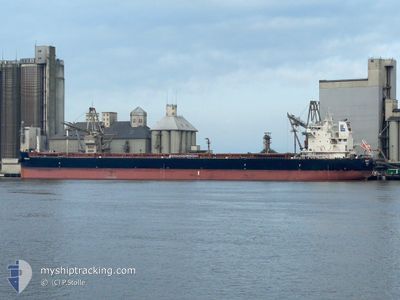
MINIMATA
Cargo

Current Trip
| Time Travelled | 2 days |
|---|---|
| Remaining Time | --- |
| Distance Travelled | 343.73 морская миля |
| Remaining Distance | --- |
| AVG Speed | 10.3 Узлы |
| MAX Speed | 11.5 Узлы |
| AVG Wind | 16.5 knots |
| MAX Wind | 30 knots |
| MIN Temp | 1.1°C / 33.98°F |
| MAX Temp | 12.2°C / 53.96°F |
| Осадка | 7.6 м |
| Позиция Получена | 3 m тому назад |
Current Position
| Долгота | --- |
|---|---|
| Широта | --- |
| Статус | At anchor |
| Скорость | |
| Курс | 42° |
| Район | Bay of Biscay |
| Станция | T-AIS |
| Позиция Получена | 3 m тому назад |
Information
The current position of MINIMATA is in Bay of Biscay with coordinates 47.65588° / -3.42248° as reported on 2025-03-03 03:59 by AIS to our vessel tracker app. The vessel's current speed is 0 Узлы
The vessel MINIMATA (IMO: 9952464, MMSI: 352002453) is a Cargo It's sailing under the flag of [PA] Panama.
In this page you can find informations about the vessels current position, last detected port calls, and current voyage information. If the vessels is not in coverage by AIS you will find the latest position.
The current position of MINIMATA is detected by our AIS receivers and we are not responsible for the reliability of the data. The last position was recorded while the vessel was in Coverage by the Ais receivers of our vessel tracking app.
The current draught of MINIMATA as reported by AIS is 7.6 meters
Weather
| Temperature | 2.2°C / 35.96°F |
|---|---|
| Wind Speed | 9 knots |
| Direction | 60° ENE |
| Pressure | 1027.3 hPa |
| Humidity | 90.8 % |
| Cloud Coverage | 66 % |


Featured Company
Last Port Calls
| Port | Arrival | Departure | Time In Port |
|---|---|---|---|
| 2025-02-22 16:12 | 2025-02-28 17:20 | 6 d | |
| 2025-01-26 18:51 | 2025-02-01 16:13 | 5 d |
Last Trips
| Origin | Departure | Destination | Arrival | Distance | |
|---|---|---|---|---|---|
| 2025-02-01 13:13 | 2025-02-22 17:12 | 4878.50 морская миля | |||
| 2024-12-18 19:37 | 2025-01-26 15:51 | 10611.27 морская миля |
Events
| Время | Событие | Детали | Позиция / Направление | Информация |
|---|---|---|---|---|
| 2025-03-02 15:38 | Статус изменился | At anchor Default |
47.65635 / -3.42293
LORIENT
|
Скорость: Курс: 54° |
| 2025-03-02 15:32 | Статус изменился | Default At anchor |
47.65633 / -3.42305
LORIENT
|
Скорость: 0.1 kn Курс: 54° |
| 2025-03-02 07:44 | Статус изменился | At anchor Default |
47.65639 / -3.42324
LORIENT
|
Скорость: 0.2 kn Курс: 59° |
| 2025-03-02 07:41 | Статус изменился | Default At anchor |
47.65632 / -3.42320
LORIENT
|
Скорость: 0.1 kn Курс: 57° |
| 2025-03-02 02:59 | Статус изменился | At anchor Under way using engine |
47.65839 / -3.42225
LORIENT
|
Скорость: 1 kn Курс: 139° |
| 2025-03-02 02:48 | Окончание движения | 1.38 nm, North East of GROIX |
47.65968 / -3.42105
LORIENT
|
Скорость: 0.3 kn Курс: 120° |
| 2025-03-02 00:44 | ETA изменился | 2025/03/02 03:00 2025/03/02 02:00 |
47.50318 / -3.75246
LORIENT
|
Скорость: 11.2 kn Курс: 39.6° |
| 2025-03-01 23:12 | Статус изменился | Under way using engine Default |
47.28861 / -4.01618
LORIENT
|
Скорость: 10.6 kn Курс: 37° |
| 2025-03-01 23:04 | Статус изменился | Default Under way using engine |
47.26823 / -4.03901
LORIENT
|
Скорость: 10.6 kn Курс: 35.9° |
| 2025-03-01 22:56 | Статус изменился | Under way using engine Default |
47.24982 / -4.05919
LORIENT
|
Скорость: 10.4 kn Курс: 37° |