
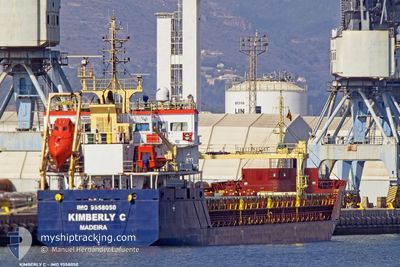
KIMBERLY C
General Cargo
Current Trip
| Time Travelled | 2 days |
|---|---|
| Remaining Time | --- |
| Distance Travelled | 460.52 морская миля |
| Remaining Distance | --- |
| AVG Speed | 9.1 Узлы |
| MAX Speed | 10.9 Узлы |
| AVG Wind | 12.9 knots |
| MAX Wind | 23.8 knots |
| MIN Temp | 19.6°C / 67.28°F |
| MAX Temp | 25.8°C / 78.44°F |
| Осадка | 6.4 м |
| Позиция Получена | Сейчас |
Current Position
| Долгота | --- |
|---|---|
| Широта | --- |
| Статус | Under way using engine |
| Скорость | 7.6 Узлы |
| Курс | 286° |
| Район | Aegean Sea |
| Станция | T-AIS |
| Позиция Получена | Сейчас |
Info
Information
The current position of KIMBERLY C is in Aegean Sea with coordinates 36.05791° / 26.94366° as reported on 2024-10-18 08:27 by AIS to our vessel tracker app. The vessel's current speed is 7.6 Узлы and is heading at the port of ROTTERDAM. The estimated time of arrival as calculated by MyShipTracking vessel tracking app is 2024-10-31 13:00 LT
The vessel KIMBERLY C (IMO: 9558050, MMSI: 255806518) is a General Cargo that was built in 2011 ( 13 лет ). It's sailing under the flag of [PT] Portugal.
In this page you can find informations about the vessels current position, last detected port calls, and current voyage information. If the vessels is not in coverage by AIS you will find the latest position.
The current position of KIMBERLY C is detected by our AIS receivers and we are not responsible for the reliability of the data. The last position was recorded while the vessel was in Coverage by the Ais receivers of our vessel tracking app.
The current draught of KIMBERLY C as reported by AIS is 6.4 meters
Weather
| Temperature | 19.6°C / 67.28°F |
|---|---|
| Wind Speed | 23 knots |
| Direction | 350° N |
| Pressure | 1017.1 hPa |
| Humidity | 55.1 % |
| Cloud Coverage | --- |
Featured Company
Last Port Calls
| Port | Arrival | Departure | Time In Port |
|---|---|---|---|
| 2024-10-15 07:52 | 2024-10-16 10:33 | 1 d | |
| 2024-10-14 20:21 | 2024-10-15 06:41 | 10 h | |
| 2024-10-09 06:56 | 2024-10-10 19:08 | 1 d | |
| 2024-10-08 04:08 | 2024-10-08 20:42 | 16 h | |
| 2024-10-03 08:42 | 2024-10-03 17:50 | 9 h | |
| 2024-09-28 18:48 | 2024-09-28 23:24 | 4 h | |
| 2024-09-21 11:53 | 2024-09-22 12:50 | 1 d | |
| 2024-09-13 05:21 | 2024-09-16 23:22 | 3 d | |
| 2024-09-02 18:08 | 2024-09-06 22:25 | 4 d | |
| 2024-08-30 17:07 | 2024-09-01 21:23 | 2 d |
Last Trips
| Origin | Departure | Destination | Arrival | Distance | |
|---|---|---|---|---|---|
| 2024-10-15 06:41 | 2024-10-15 07:52 | 4.59 морская миля | |||
| 2024-10-10 19:08 | 2024-10-14 20:21 | 911.85 морская миля | |||
| 2024-10-08 20:42 | 2024-10-09 06:56 | 72.13 морская миля | |||
| 2024-10-03 17:50 | 2024-10-08 04:08 | 1007.77 морская миля | |||
| 2024-09-28 23:24 | 2024-10-03 08:42 | 991.81 морская миля | |||
| 2024-09-22 12:50 | 2024-09-28 18:48 | 1458.27 морская миля | |||
| 2024-09-16 23:22 | 2024-09-21 11:53 | 97.25 морская миля | |||
| 2024-09-06 22:25 | 2024-09-13 05:21 | 1419.23 морская миля | |||
| 2024-09-01 21:23 | 2024-09-02 18:08 | 163.83 морская миля | |||
| 2024-08-28 13:07 | 2024-08-30 17:07 | 34.78 морская миля |
Events
| Время | Событие | Детали | Позиция / Направление | Информация |
|---|---|---|---|---|
| 2024-10-18 03:29 | Изменение морского района | Greek part of the Aegean Sea Greek part of the Mediterranean Sea - Eastern Basin |
35.84177 / 27.67106
Aegean Sea
NL RTM
|
Скорость: 9 kn Курс: 296° |
| 2024-10-17 22:02 | Изменение морского района | Greek part of the Mediterranean Sea - Eastern Basin Turkish part of the Mediterranean Sea - Eastern Basin |
35.82789 / 28.77267
Mediterranean Sea - Eastern Basin
NL RTM
|
Скорость: 9.2 kn Курс: 272° |
| 2024-10-17 21:34 | Изменение морского района | Turkish part of the Mediterranean Sea - Eastern Basin Greek part of the Mediterranean Sea - Eastern Basin |
35.83196 / 28.85885
Mediterranean Sea - Eastern Basin
NL RTM
|
Скорость: 9.5 kn Курс: 262° |
| 2024-10-17 21:32 | В покрытии |
35.83196 / 28.85885
Mediterranean Sea - Eastern Basin
NL RTM
|
Скорость: 9.5 kn Курс: 262° |
|
| 2024-10-17 18:39 | Статус изменился | Default Under way using engine |
35.87232 / 29.48291
NL RTM
|
Скорость: 10.9 kn Курс: 266° |
| 2024-10-17 18:12 | Обнаружено в море | Greek part of the Mediterranean Sea - Eastern Basin |
35.87848 / 29.58376
Mediterranean Sea - Eastern Basin
NL RTM
|
Скорость: 10.9 kn Курс: 266° |
| 2024-10-17 18:12 | Вне покрытия |
35.87848 / 29.58376
Mediterranean Sea - Eastern Basin
NL RTM
|
Скорость: 10.9 kn Курс: 266° |
|
| 2024-10-17 17:09 | В покрытии |
35.89897 / 29.81144
Mediterranean Sea - Eastern Basin
NL RTM
|
Скорость: 10.7 kn Курс: 263° |
|
| 2024-10-16 14:44 | Статус изменился | Default Under way using engine |
36.30833 / 35.15077
NL RTM
|
Скорость: 10 kn Курс: 250.6° |
| 2024-10-16 14:42 | Вне покрытия |
36.31037 / 35.15782
Mediterranean Sea - Eastern Basin
NL RTM
|
Скорость: 10 kn Курс: 250.6° |