
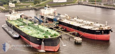
KARAVAS
Crude Oil Tanker
Current Trip
| Time Travelled | 39 days |
|---|---|
| Remaining Time | 4 days |
| Distance Travelled | 7152.57 морская миля |
| Remaining Distance | 648.84 морская миля |
| AVG Speed | 10.4 Узлы |
| MAX Speed | 14.4 Узлы |
| AVG Wind | 13.9 knots |
| MAX Wind | 38 knots |
| MIN Temp | 9°C / 48.2°F |
| MAX Temp | 21.6°C / 70.88°F |
| Осадка | 8.5 м |
| Позиция Получена | 8 h, 12 m тому назад |
Current Position
| Долгота | --- |
|---|---|
| Широта | --- |
| Статус | Under way using engine |
| Скорость | 1.9 Узлы |
| Курс | 269° |
| Район | Aegean Sea |
| Станция | T-AIS |
| Позиция Получена | 8 h, 12 m тому назад |
Info
Information
The current position of KARAVAS is in Aegean Sea with coordinates 38.82482° / 26.50247° as reported on 2026-01-08 22:32 by AIS to our vessel tracker app. The vessel's current speed is 1.9 Узлы and is heading at the port of VALLETTA. The estimated time of arrival as calculated by MyShipTracking vessel tracking app is 2026-01-13 20:39 LT
The vessel KARAVAS (IMO: 9420631, MMSI: 355600000) is a Crude Oil Tanker that was built in 2010 ( 16 лет ). It's sailing under the flag of [PA] Panama.
In this page you can find informations about the vessels current position, last detected port calls, and current voyage information. If the vessels is not in coverage by AIS you will find the latest position.
The current position of KARAVAS is detected by our AIS receivers and we are not responsible for the reliability of the data. The last position was recorded while the vessel was in Coverage by the Ais receivers of our vessel tracking app.
The current draught of KARAVAS as reported by AIS is 8.5 meters
Weather
| Temperature | 9.4°C / 48.92°F |
|---|---|
| Wind Speed | 25 knots |
| Direction | 318° NW |
| Pressure | 1012.7 hPa |
| Humidity | 46.7 % |
| Cloud Coverage | 65 % |
Featured Company
Events
| Время | Событие | Детали | Позиция / Направление | Информация |
|---|---|---|---|---|
| 2026-01-08 22:38 | Статус изменился | Default Under way using engine |
38.82280 / 26.49986
MALTA
|
Скорость: 1.9 kn Курс: 269° |
| 2026-01-08 22:32 | Статус изменился | Under way using engine Default |
38.82482 / 26.50247
MALTA
|
Скорость: 2.1 kn Курс: 264° |
| 2026-01-08 22:32 | Вне покрытия |
38.82482 / 26.50247
Aegean Sea
MALTA
|
Скорость: 1.9 kn Курс: 216.4° |
|
| 2026-01-08 21:50 | Статус изменился | Default Under way using engine |
38.83638 / 26.52315
MALTA
|
Скорость: 1.9 kn Курс: 269° |
| 2026-01-08 21:45 | Статус изменился | Under way using engine Default |
38.83639 / 26.52657
MALTA
|
Скорость: 1.5 kn Курс: 268° |
| 2026-01-08 21:26 | В покрытии |
38.83639 / 26.52657
Aegean Sea
MALTA
|
Скорость: 1.9 kn Курс: 268.6° |
|
| 2026-01-08 16:13 | Статус изменился | Default Under way using engine |
38.85118 / 26.50904
MALTA
|
Скорость: 2.4 kn Курс: 247° |
| 2026-01-08 16:06 | Вне покрытия |
38.85462 / 26.51314
Aegean Sea
MALTA
|
Скорость: 2.4 kn Курс: 207.4° |
|
| 2026-01-08 15:49 | Статус изменился | Under way using engine Default |
38.86411 / 26.51785
MALTA
|
Скорость: 2.1 kn Курс: 236° |
| 2026-01-08 15:32 | Статус изменился | Default Under way using engine |
38.87667 / 26.52500
MALTA
|
Скорость: 3.8 kn Курс: 287° |