
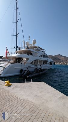
BUNTY
Pleasure Craft
Current Trip
| Trip Time | 21 mins |
|---|---|
| Trip Distance | 4.14 морская миля |
| AVG Speed | 8.2 Узлы |
| MAX Speed | 13.4 Узлы |
| Осадка | 0 м |
| AVG Wind | 6.9 knots |
| MAX Wind | 7.2 knots |
| MIN Temp | 22.3°C / 72.14°F |
| MAX Temp | 22.3°C / 72.14°F |
| Позиция Получена | 20 h, 18 m тому назад |
Current Position
| Долгота | 7.60051° |
|---|---|
| Широта | 43.78801° |
| Статус | Default |
| Скорость | |
| Курс | --- |
| Район | Ligurian Sea |
| Станция | T-AIS |
| Позиция Получена | 20 h, 18 m тому назад |
Info
Information
The current position of BUNTY is in Ligurian Sea with coordinates 43.78801° / 7.60051° as reported on 2024-07-03 13:01 by AIS to our vessel tracker app. The vessel's current speed is 0 Узлы and is currently inside the port of CALA DEL FORTE.
The vessel BUNTY (MMSI: 319117700) is a Pleasure Craft It's sailing under the flag of [KY] Cayman Is.
In this page you can find informations about the vessels current position, last detected port calls, and current voyage information. If the vessels is not in coverage by AIS you will find the latest position.
The current position of BUNTY is detected by our AIS receivers and we are not responsible for the reliability of the data. The last position was recorded while the vessel was in Coverage by the Ais receivers of our vessel tracking app.
Weather
| Temperature | 22.1°C / 71.78°F |
|---|---|
| Wind Speed | 4 knots |
| Direction | 124° SE |
| Pressure | 1006.4 hPa |
| Humidity | 74.1 % |
| Cloud Coverage | 100 % |
Featured Company
Last Port Calls
| Port | Arrival | Departure | Time In Port |
|---|---|---|---|
| 2024-07-02 11:56 | |||
| 2024-07-02 11:31 | 2024-07-02 11:35 | 4 m | |
| 2024-05-27 15:41 | 2024-07-02 08:12 | ||
| 2024-05-27 12:17 |
Last Trips
| Origin | Departure | Destination | Arrival | Distance | |
|---|---|---|---|---|---|
| 2024-07-02 13:35 | 2024-07-02 13:56 | 4.14 морская миля | |||
| 2024-07-02 10:12 | 2024-07-02 13:31 | 38.87 морская миля | |||
| 2024-05-27 14:17 | 2024-05-27 17:41 | 33.25 морская миля |
Events
| Время | Событие | Детали | Позиция / Направление | Информация |
|---|---|---|---|---|
| 2024-07-03 13:01 | Вне покрытия |
43.78801 / 7.60051
Ligurian Sea
[IT] CALA DEL FORTE
|
Скорость: Курс: 141.7° |
|
| 2024-07-03 12:25 | В покрытии |
43.78802 / 7.60050
Ligurian Sea
[IT] CALA DEL FORTE
|
Скорость: Курс: 141.7° |
|
| 2024-07-03 10:52 | Вне покрытия |
43.78801 / 7.60049
Ligurian Sea
[IT] CALA DEL FORTE
|
Скорость: Курс: 141.7° |
|
| 2024-07-02 11:59 | Окончание движения |
43.78850 / 7.59999
[IT] CALA DEL FORTE
|
Скорость: 0.2 kn Курс: 511° |
|
| 2024-07-02 11:56 | Порт |
|
43.78780 / 7.59718
[IT] CALA DEL FORTE
|
Скорость: 4.8 kn Курс: 72.6° |
| 2024-07-02 11:35 | ПОРТ ОТПРАВЛЕНИЯ |
|
43.78788 / 7.59324
|
Скорость: 6.6 kn Курс: 287.5° |
| 2024-07-02 11:35 | Начало движения |
43.78814 / 7.59564
[IT] CALA DEL FORTE
|
Скорость: 6.6 kn Курс: 287.5° |
|
| 2024-07-02 11:33 | Окончание движения |
43.78802 / 7.59829
[IT] CALA DEL FORTE
|
Скорость: 0.2 kn Курс: 511° |
|
| 2024-07-02 11:31 | Порт |
|
43.78782 / 7.59676
[IT] CALA DEL FORTE
|
Скорость: 4.8 kn Курс: 59.4° |
| 2024-07-02 11:23 | Изменение морского района | Italian part of the Ligurian Sea Italian part of the Mediterranean Sea - Western Basin |
43.77146 / 7.58430
Ligurian Sea
|
Скорость: 12.6 kn Курс: 11.4° |